| Davis Fire | |
|---|---|
| Part of 2024 Nevada wildfires | |
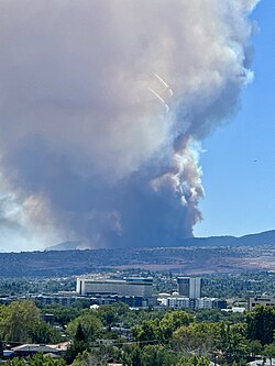 Smoke from the Davis Fire on September 8 | |
| Date |
|
| Location | Washoe County, Nevada, 20 miles south of Reno |
| Statistics | |
| Burned area | 5,824 acres (2,357 ha) |
| Land use | Private, state, and federal land |
| Impacts | |
| Deaths | 0 |
| Injuries | 1 firefighter |
| Evacuated | 20,000 |
| Structures destroyed | 16 primary, 22 outbuildings |
| Cost | $12.6 million (supression efforts) $2 million (park restoration efforts) |
| Ignition | |
| Cause | Improperly extinguished campfire |
| Motive | Accidental |
| Map | |
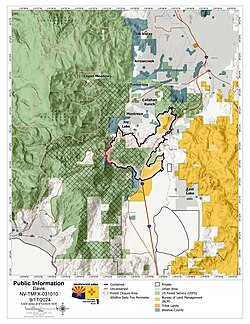 Map of the Davis Fire on September 17 | |
The Davis Fire was a destructive, fast-moving wildfire that burned in Washoe Valley, Nevada in September 2024. After igniting in Davis Creek Regional Park due to an improperly extinguished campfire around 2:30 pm on September 7. The fire destroyed sixteen primary structures and twenty-two outbuildings, burned 5,824 acres (2,357 ha), injured one firefighter, and prompted evacuations for roughly 20,000 people.
The fire rapidly grew to 1,500 acres (610 ha) the night it started, prompting evacuations in Washoe Valley and south Reno and closing several roads. By the next morning, it was estimated at 6,500 acres (2,600 ha) and a state of emergency had been issued. The fire size was confirmed at 4,703 acres (1,903 ha). A red flag warning was issued on September 10 as the fire grew to roughly 5,600 acres (2,300 ha). On September 11, a particularly dangerous situation was issued by the National Weather Service Reno due to strong winds gusting up to 75 miles per hour (121 km/h) from a cold front moving in, with projections showing the fire spreading between 3–7 miles (4.8–11.3 km) north. However, crews were able to control spread of the fire west of State Route 431 and evacuations were reduced on September 12. The fire had grown to 5,824 acres (2,357 ha). The fire received moisture due to the cold front. A burned area emergency response team began assessing the burned area on September 17 and the Davis Fire reached 100% containment on September 25, 2024.
At its peak, the Davis Fire threatened 36,000 structures. Among the destroyed structures was the Holy Spirit Catholic Mission, the only church that held a Latin mass in Northern Nevada. Suppression efforts cost roughly $12.6 million and the cost for restoring Davis Creek Regional Park is estimated to be at least $2 million. One bear who received extensive burns was euthanized by the Nevada Department of Wildlife.
Background
Over the first ten days of September 2024 there were above average peak temperatures in valleys in Western Nevada around 90 °F (32 °C). Strong regional winds contributed the fire's spread on the day of ignition.1 On September 11, there were sustained winds up to 40 mph (64 km/h)2 caused by a low-pressure area passing over the Pacific Northwest, with the Reno area around the southern point.3 Across the Western United States, climate change has caused more impactful heat waves and has led to an increase of wildfires in the Western United States.45
Overall, wildfires in Nevada throughout 2024 spread quicker and ignited easier due to an abundance invasive cheatgrass. The two previous winters, 2022–23 and 2023–24, had an above–average snowpack, leading to an abundance of cheatgrass. The cheatgrass dried out throughout the fire season, giving wildfires a plentiful amount of dry fuel.6 Additionally, there were dry conditions throughout the state as a whole,7 including all of Western Nevada experiencing at least abnormally dry conditions.8 The portions of Humboldt-Toiyabe National Forest the Davis Fire burned in areas where the forest was much denser than it was historically.9 Many forests in the Sierra Nevada region have grown denser due to strict orders to immediately suppress all wildfires.10 There were large areas of dry fire fuels that included pine needles, dead leaves, and dead tree limbs.11 The fire primarily burned in dry brush.12
Many structures were threatened because the fire took place in the heavily populated foothills of the Carson Range. These structures were in a wildfire urban interface where there are urban communities in wildfire prone areas.13
The Truckee Meadows Fire Protection District (TMFPD) station that would have been closest to the location of the Davis Fire, the Bowers Mansion station, was permanently closed in 2022 after a bat infestation. TMFPD reported repairs would have cost tens of thousands of dollars. The station was 2 miles (3.2 km) away, and the closest operating one during the fire was the Eastlake Station, with KRNV-DT reporting driving from the Bowers Mansion station from the scene took under two minutes while driving from the Eastlake Station took roughly five minutes and thirty seconds. A resident stated having a closer station would have helped "big time" in combatting the fire.14
Cause
The Davis Fire was first reported in the day use area of Davis Creek Regional Park around 2:30 pm on September 7, 2024, and was burning in heavy timber and brush.15 After extensive investigations, the fire was determined to have been started by a prohibited and improperly extinguished campfire, with an accidental motive and no criminal activity involved.16
Progression
September 7–11

On September 7 around 2:30 pm, a three-acre vegetation fire was reported burning in heavy timber and brush in Davis Creek Regional Park. The fire quickly destroyed structures in the park.1517 Evacuations orders were prompted for southwest Reno, New Washoe City, and an evacuation warning for Virginia City Highlands.a Interstate 580 was closed in both directions from Damonte Ranch Parkway in Reno to College Parkway in Carson City. A resident stated, "traffic was backed up for miles on backroads out of Washoe Valley". The fire spread to 1,500 acres (610 ha) that evening. An evacuation center was put into place at the Washoe County Senior Citizen Center.19 Washoe County Regional Animal Services had mobile shelters for small animals, and large animal shelters were located the University of Nevada, Reno Equestrian Center in Reno and Fuji Park and Silver Saddle Ranch in Carson City. Employees at the Nevada Governor's Office contacted agencies from several other states to assist with containing the fire. U.S. Route 395 Alternate was closed in Washoe Valley.2021 NV Energy cut power to 18,698 customers. Those who had not yet lost power were told to prepare for "potential long outages".22
On September 8, Davis Fire had grown to 6,500 acres (2,600 ha) and had made an extreme northwards spread along State Route 431, also known as Mount Rose Highway.23 Interstate 580 had reopened between Reno and Carson City, along with Alternate US 395 to the interchange with Bowers Mansion Road. Between 12,000 and 14,000 were impacted by evacuation notices, and several hotels were giving discounted rates on rooms for evacuees.24 Evacuations north of Mount Rose Highway that were lifted overnight were reinstated.25 Governor Joe Lombardo declared a state of emergency due to the Davis Fire, and Washoe County declared an emergency proclamation.26 Fire crews were prioritized keeping the fire south and east of Mount Rose Highway.27 Evacuations expanded that night as winds drove the fire towards Mount Rose Highway.28
The estimated size was lowered to 4,703 acres (1,903 ha).28 Active fire behavior was observed on the southwestern edge near Mount Rose Highway on September 9. Despite aircraft limitations from strong wind and smoke, crews utilized roads and natural features. Local strike teams prioritized structure protection, and out-of-state resources were sent in.29 Between twelve and fourteen thousand people were under evacuation orders.30 The evacuation warning for Virginia City Highlands was lifted and most power had been restored.31
A red flag warning was issued on September 10, allowing the fire to spread to 5,600 acres (2,300 ha).32 So far, suppression efforts cost $1.2 million.33 Crews worked on controlling the fire's perimeter, particularly with high activity.29 Containment increased to 31% and a community meeting was held that night.34 Evacuations orders were reduced to evacuation warningsa in Pleasant Valley and Washoe City.35

A particularly dangerous situation was issued for September 11 because forecasts predicted sustained winds from 40–70 mph (64–113 km/h), mostly from a cold front moving over the area.2934 This was the sixth particularly dangerous situation issued by the National Weather Service Reno, the first since 2019.3637 Evacuation warningsa were issued in west Reno up to State Route 659.35 Overnight, the fire spotted over Mount Rose Highway.38 The strong winds grounded firefighting aircraft.39 All off–duty firefighters were ordered to work on the fire.40 However, there was only slight growth on the fire and crews held the fire where it spotted Mount Rose Highway..4138 There were 600 firefighters, 58 fire engines, 12 helicopters, and 10 bulldozers combatting the fire.42 The fire grew to 5,824 acres (2,357 ha) and was 37% contained. 2,600 structures were still threatened. All evacuation orders and warnings remained in place because of the fire's remaining threat to grow overnight.43
September 12 onwards
Winds had subsided on September 12 with cooler temperatures around 70 °F (21 °C), and humidity levels had reached 60%.44 The fire stayed within its footprint, and crews achieved 56% containment.45 Containment lines were established for the northernmost part of the fire, the area of the fire that posed the greatest risk to homes in Reno.46 Half of the customers without power re-energized, and several evacuations warnings were lifted.47
On September 13, crews conducted firing operations near Winter Creek Road. Evacuation orders were lifted in Montreux.11 A cold front that blew in brought moisture on September 14 that would last for several days.48 Containment increased to 76%, and evacuation orders in Galena and St. James Village were lowered to evacuation warnings.a49 On September 15, firefighters changed suppression to promote forest regrowth by removing resources from secured areas. Fire crews stopped requesting donations.50
The fire was at 85% containment by September 16 and the entirety of Mount Rose Highway reopened. "Widespread showers" were reported.512 On September 17, the fire was now 92% contained, and a burned area emergency response and local agencies began conducting a damage assessment in the burned area.52 Crews were split between patrolling the fire's perimeter and repairing the effected area. There were no more mop up or suppression efforts.2
The Davis Fire was fully contained on September 25, 2024, at a final size of 5,824 acres (2,357 ha).53
Effects
Damage
The Davis Fire destroyed fourteen residential structures, two commercial structures, and twenty-two outbuildings.2 The fire destroyed the Holy Spirit Catholic Mission, which hosted the only Latin mass in Northern Nevada. Nearly all church documents were also lost.54 The Chocolate Nugget Candy Factory was almost burned down the by the fire, which came one foot (0.30 m) from the entrance.55 The Davis Fire over 36,000 structures.56
Washoe County experienced a shortage of resources to fight the fire.57 Suppression efforts cost about $12.6 million.58
On September 11, Truckee Meadows Water Authority "urged" residents in southwest Reno to stop outdoor watering and a minimize separate water usage.59 On September 7, 18,698 NV Energy customers were affected by power outages in the Reno area.22 A public safety outage watch was issued in Carson City, Glenbrook, and Genoa for 322 customers.60 Three broadcast stations on Slide Mountain were affected by power outages.61
Davis Creek Regional Park
The fire burned about 118 acres (48 ha) out of the 265 acres (107 ha) in Davis Creek Regional Park. Costs to repair the park are expected to exceed $2 million for a ranger residence and garage, electric infrastructure, five outbuildings, an amphitheater, a utility trailer, and various small equipment and utilities. Several restoration efforts have occurred, including erosion prevention, reseeding, and rebuilding.62 The park remained closed throughout 2025, while Davis Creek Campground and the equestrian center have remained closed. Davis Creek Regional Park was closed after the Davis Fire and remained closed throughout 2025, after causing heavy infrastructure damage.6364
Injuries
One firefighter suffered an eye injury that was described as "life–altering" and "possibly career-ending" by the Reno Firefighters Association, and he lost sight in his eye.65 A bear injured in the fire was treated by the Nevada Department of Wildlife for third degree burns.66 Ultimately, the bear was euthanized.67
Closures and evacuations
The Washoe County School District (WCSD) cancelled classes for several schools between September 9 and September 13. Thus, the school district also cancelled the professional learning day scheduled for January 6, 2025 and elementary spring parent–teacher conferences.68 That same week, in-person classes at the University of Nevada, Reno Redfield Campus were cancelled.69 Firefighters closed and temporarily repurposed South Valleys Library as a command post.70
Several roads were closed during the Davis Fire, including Interstate 580 from Damonte Ranch Parkway in Reno to College Parkway in Carson City, U.S. 395 Alternate, and Mount Rose Highway.71 Then–vice president candidate Tim Walz postponed a rally scheduled in Reno on September 9.72 The event was rescheduled for October 8.73
Twenty thousand people were under evacuation notices in south Reno, New Washoe City, and Washoe Valley.74 Guards were stationed in evacuated areas due to reports of looters.35
The United States Forest Service (USFS) issued an emergency closure for portions of Humboldt-Toiyabe National Forest to protect civilians and firefighters.75 Mt. Rose Campground was temporarily closed but was reopened after the fire was fully contained.76 Galena Creek Regional Park was temporarily closed.69
Environmental impacts

The Northern Nevada Public Health Air Quality Management Division issued an air quality advisory. Air quality monitors in southern Washoe County reached unhealthy levels.77 Along with the Bridge, Line, and Airport fires in Southern California, smoke pollution was reported in Southern Nevada.78
Investigations and damage assessments reported that most soil would not be severely damaged by the fire, and afflicted soil will likely recover in the next five years.79 Several areas were found to be at risk to major erosion or runoff during periods of heavy rain and an increased flash flood risk due to water–repellent soil.80 As the fire burned in the foothills and at the base of Slide Mountain, avalanches and rockslides were expected to occur in the burned area. The Washoe Valley Watershed was polluted with ash.81 The National Weather Service warned trees burned by the Davis Fire could be blown down during high wind events, with advisories documented as late as February 15, 2026.82
Growth and containment table
| Date | Area burned | Personnel | Containment | Ref. | ||
|---|---|---|---|---|---|---|
| September 7 | 1,500 acres (610 ha; 6.1 km2) | Unknown | 0%
|
83 | ||
| September 8 | 6,500 acres (2,600 ha; 26 km2) | 600 | 0%
|
84 | ||
| September 9 | 5,000 acres (2,000 ha; 20 km2)b | 0%
|
85 | |||
| September 10 | 5,596 acres (2,265 ha; 22.65 km2) | 423 | 0%
|
86 | ||
| September 11 | 5,646 acres (2,285 ha; 22.85 km2) | 620 | 31%
|
87 | ||
| September 12 | 5,824 acres (2,357 ha; 23.57 km2) | 631 | 37%
|
44 | ||
| September 13 | 685 | 56%
|
88 | |||
| September 14 | 710 | 76%
|
89 | |||
| September 15 | 642 | 76%
|
90 | |||
| September 16 | 526 | 85%
|
91 | |||
| September 17 | 492 | 92%
|
92 | |||
| September 18 | 342 | 93 | ||||
| — | ||||||
| September 25 | 5,824 acres (2,357 ha; 23.57 km2) | Unknown | 100%
|
53 | ||
See also
See also
Notes
Notes
- An evacuation warning signifies there is a potential threat to life or property and an evacuation order is a lawful order to evacuate due to immediate threat to life or property.18
- Due to more accurate mapping.
References
References
- "Monthly Climate Report September 2024" (PDF). Retrieved February 9, 2025.
- Drysdale, Bethany. "Davis Fire Timeline, Recap, and Resources". Washoe Life. Retrieved February 18, 2025.
- Graff, Amy (September 10, 2024). "Strong winds enter forecast as Davis Fire near Reno burns out of control". SFGATE. Retrieved March 14, 2025.
- Fox, Chloe. "Officials warn of "dangerous situation" in Nevada as wildfires escalate". Air Med & Rescue. Retrieved March 2, 2025.
- Boyette, Chris; Von Quednow, Cindy (September 11, 2024). "Bridge, Line, Airport, and Davis fires grow in California and Nevada, displacing thousands". CNN. Retrieved March 7, 2025.
- Solis, Jennifer (June 26, 2024). "Nevada faces heightened wildfire potential this summer, state forester says". Nevada Current. Retrieved March 7, 2025.
- Glenn, Matthew. "2024 Nevada wildfire update" (PDF). Retrieved March 7, 2025.
- Johnson, Lindsay (September 9, 2024). U.S. Drought Monitor Nevada – September 9, 2024. droughtmonitor.unl.edu (picture). Retrieved July 2, 2026.
- Ramos, Eli (September 23, 2024). "Wildfire experts weigh in on the effects of the Davis Fire". Tahoe Daily Tribune. Retrieved March 13, 2025.
- "Healthy and Resilient Forests". wildfiretaskforce.org. Retrieved July 3, 2026.
- "Update on Davis Fire for September 13, 2024". Truckee Meadows Fire and Rescue. Retrieved March 13, 2025.
- Munson, Jeff (September 7, 2024). "Evacuations continue as firefighters battle fast wildfire near Davis Creek in Washoe Valley, I-580 closed". Carson Now. Retrieved March 14, 2025.
- Brown-Davis, Julie (September 11, 2024). "'Extremely dangerous' situation fire conditions threaten hundreds of Reno homes". SFGATE. Retrieved March 12, 2025.
- Margiott, Ben (September 10, 2024). "Truckee Meadows fire station closest to Davis Fire origin closed permanently in 2022". KRNV-DT. Retrieved July 14, 2025.
- Drysdale, Bethany. "Davis Creek Regional Park and South Reno Structures Lost in Davis Fire". Washoe Life. Retrieved April 21, 2025.
- Downs, Brandon (May 8, 2025). "Davis Fire that destroyed 13 homes near Reno in 2024 classified as accidental, investigators say". CBS News. Retrieved May 8, 2025.
- "Davis Fire Map". Watch Duty. Retrieved July 3, 2026.
- "Know the Difference: What Evacuation Warnings and Orders Mean". www.news.caloes.ca.gov. March 14, 2023. Retrieved July 3, 2026.
- Santoro, McAndrew, Hidalgo, McGinness, Peggy, Siobhan, Jason, Brett. "Davis Fire: 6,500 acres burned, multiple homes destroyed, WCSD cancels school". Reno Gazette Journal. Retrieved January 16, 2025.
{{cite news}}: CS1 maint: multiple names: authors list (link) - "Davis Fire Updates: Sept. 7-10". Nevada Public Radio. Retrieved January 5, 2025.
- Munson, Jeff. "Davis Fire picks up again; I-580 opens up through Washoe Valley". Carson Now. Retrieved January 5, 2025.
- "Davis Fire Updates". www.nvenergy.com. September 11, 2024. Retrieved July 3, 2026.
- Peterson, Paula (September 8, 2024). "Davis Fire picks up again under Red Flag Warnings". South Tahoe Now. Retrieved March 14, 2025.
- "Update on Davis Fire for September 8, 2024". Truckee Meadows Fire and Rescue. Retrieved January 22, 2025.
- Graff, Amy (September 8, 2024). "Wildfire outside Reno shuts down Nevada highway, burns down homes". SFGATE. Retrieved March 17, 2025.
- "Nevada governor declares state of emergency due to Davis Fire". Carson Now. Retrieved January 23, 2025.
- Munson, Jeff (September 9, 2024). "Monday evening Davis Fire update: 5,000 acres, no containment, 14 structures impacted". Carson Now. Retrieved February 28, 2025.
- Marks, Eric (September 9, 2025). "PHOTOS: Davis Fire puts Washoe County in state of emergency". This is Reno. Retrieved July 17, 2025.
- Munson, Jeff (September 10, 2024). "Davis Fire update Tuesday: 5,596 acres, no containment, rare 'PDS' Red Flag Warning goes up". Carson Now. Retrieved July 17, 2025.
- Graff, Amy (September 9, 2024). "Up to 14,000 people evacuated ahead of wildfire burning south of Reno". SFGATE. Retrieved July 17, 2025.
- Johnson, Bert (September 9, 2024). "Gusty winds could hamper progress on Davis Fire". KUNR. Retrieved July 17, 2025.
- Lentthang, Marlene; Bush, Evan; Helsel, Phil (September 10, 2024). "Wildfires hit California and Nevada, prompting evacuations and power outages". NBC News. Retrieved March 20, 2025.
- Hildebrand, Kurt (September 10, 2024). "Red flag warning issued for today and Wednesday as Davis Fire burns". The Record-Courier. Retrieved August 7, 2025.
- Burke, Taylor (September 10, 2024). "Davis Fire community meeting reveals more evacuations are expected". KOLO-TV. Retrieved July 3, 2026.
- Hackbarth, Kristen (September 11, 2024). "Community expresses fear, concern, gratitude following Davis Fire update". This is Reno. Retrieved February 28, 2025.
- Mascarenhas, Lauren; Sykes, Jillian. "A 'particularly dangerous situation' develops as wildfires rage in the West". CNN. Retrieved February 15, 2025.
- "Update on Davis Fire for September 11, 2024". Truckee Meadows Fire and Rescue. Retrieved February 15, 2025.
- Davis Fire Reflections. YouTube: University of Nevada, Reno. August 13, 2025. Retrieved July 5, 2026.
- McGiness, Brett; McAndrew, Siobhan; Hidalgo, Jason; Meehan, Jeffery; Young, Jaedyn (September 11, 2024). "Davis Fire updates: WCSD to keep 10 schools closed on Thursday". Reno Gazette–Journal. Retrieved July 3, 2026.
- Garcia, Eugena; Rodriguez, Olga (September 10, 2024). "Wildfires burn out of control in Southern California and more evacuations ordered". Associated Press. Retrieved April 22, 2025.
- Peterson, Paula (September 11, 2024). "Fire has been kept within Davis Fire perimeter despite high winds". South Tahoe Now. Retrieved February 27, 2025.
- Pehling, David (September 10, 2024). "Davis Fire south of Reno still raging as Red Flag Warning goes into effect". CBS News. Retrieved March 16, 2025.
- "Davis Fire: Relief expected as winds die down and humidity rises; national forest lands closed". KUNR. September 11, 2024. Retrieved July 17, 2025.
- "Davis Fire Update 09-12-2024". InciWeb. Archived from the original on July 9, 2025. Retrieved February 27, 2025.
- "Davis Fire Thursday Night update: Containment grows to 56 percent". www.carsonnow.org. September 12, 2024. Retrieved August 7, 2025.
- Haas, Greg (September 12, 2024). "'No perimeter growth': Davis Fire near Reno held in check despite dire wind conditions". 8 News Now. Retrieved March 19, 2025.
- Halaly, Alan (September 12, 2024). ""When are we going to wake up from this?": Davis Fire still displacing thousands". Las Vegas Review-Journal. Retrieved August 7, 2025.
- Vong, Annie (September 14, 2024). "Davis Fire near Reno is 76% contained, officials say". Las Vegas Review-Journal. Retrieved March 19, 2025.
- "Davis Fire 76% contained, having burned about 6,000 acres". This is Reno. September 14, 2024. Retrieved August 7, 2025.
- "Davis Fire Update: Containment grows as crews tackle hotspots". This is Reno. September 15, 2024. Retrieved August 7, 2025.
- Munson, Jeff (September 16, 2024). "Monday morning Davis Fire update: 85% contained, Mt. Rose Highway open". Carson Now. Retrieved March 8, 2025.
- "Forest Service begins post-fire assessment of Davis Fire damage". My News 4. September 19, 2024. Retrieved March 8, 2025.
- "Davis Fire reaches 100% containment, all residential evacuations lifted". Fox 11 Reno. September 25, 2024. Retrieved April 9, 2025.
- Margiott, Ben (September 10, 2024). "Holy Spirit Catholic Mission destroyed in Davis Fire, parishioners search for sacred items". My News 4. Retrieved March 19, 2025.
- Barlett, Amanda (September 8, 2024). "'Fire was coming right at us': Historic tourist spot nearly destroyed in wildfire near Reno". SFGATE. Retrieved March 14, 2025.
- DeSilva, Kristen. "Davis Fire near Reno mostly contained, officials say". Nevada Public Radio. Retrieved February 28, 2025.
- "Declaration of Emergency The Davis Fire". gov.nv.gov. Archived from the original on September 11, 2024. Retrieved April 5, 2025.
- "Davis - Wildfire and Smoke Map". data.rgj.com. Retrieved July 3, 2026.
- "Southwest Reno residents urged to stop outdoor watering Wednesday amid Davis Fire strains". FOX 11. September 11, 2024. Retrieved March 23, 2025.
- Hildebrand, Kurt (September 9, 2024). "NV Energy cancels public safety power outage for Genoa, Glenbrook, and Carson". The Recourd-Courier. Retrieved April 10, 2025.
- "Davis Fire outages knock out Slide Mountain transmitters". The Record-Courier. September 10, 2024. Retrieved February 27, 2025.
- Steuer, Nick. "Davis Creek Park Fire Restoration" (PDF). washoecounty.gov. Retrieved July 3, 2026.
- "Davis Creek Regional Park". washoecounty.gov. Retrieved January 3, 2026.
- "Davis Creek Campground". www.washoecounty.gov. Retrieved July 4, 2026.
- "Donation sought for firefighter who suffered possibly career-ending injury protecting homes in the Davis Fire". 2 News Nevada. September 13, 2024. Retrieved February 27, 2025.
- "Bear injured in Davis Fire moved to facility north of Reno". Nevada Appeal. Retrieved March 7, 2025.
- "Bear in Davis Fire Euthanized". Nevada Department of Wildlife. Retrieved March 13, 2025.
- "WCSD cuts Winter Break short to make up for missed classes during the Davis Fire". 2 News Nevada. November 7, 2024. Retrieved February 26, 2025.
- Hackbarth, Kristen (September 12, 2024). "Some closures continue in wake of Davis Fire". This is Reno. Retrieved March 16, 2025.
- "Davis Fire crews to patrol containment lines; 5,824-acres, 92% contained". 2 News Nevada. September 18, 2024. Retrieved March 16, 2025.
- Penrose, Kelsey (September 7, 2024). "Evacuations and Road Closures for Davis Creek Fire". Carson Now. Retrieved March 3, 2025.
- Zalucki, Rachel (September 9, 2024). "Gov. Tim Walz to postpone Reno rally as Davis fire continues to burn". Fox 5 Vegas. Retrieved April 9, 2025.
- Ramirez, Lizzie (October 9, 2024). "PHOTOS: Governor Tim Walz visits Reno for two campaign stops". This is Reno. Retrieved April 9, 2025.
- Haas, Greg. "UPDATE: Davis Fire prompts 20K evacuations, cancels classes in the Reno area". 8 News Now. Retrieved February 28, 2025.
- "Davis Fire". nevada.gov. Archived from the original on October 2, 2024. Retrieved February 27, 2025.
- "Mt. Rose campground reopens after Davis Fire but only for limited time". 2 News Nevada. September 25, 2024. Retrieved March 14, 2025.
- "Davis Creek Regional Park and south Reno structures lost in #DavisFire". www.emergencywashoe.com. Retrieved July 3, 2026.
- "Davis Fire and Smoke in Southern Nevada". Nevada Office of State Epidemiology. Retrieved March 12, 2025.
- Timko, Steve (November 7, 2024). "Davis Fire report: Most soil not severely damaged by fire; good recovery chances within next 5 years". KOLO-TV. Retrieved March 6, 2025.
- Lincoln, Sophie (September 20, 2024). "Davis Fire burn scar poses threats of future flash flooding, debris flows". My News 4. Retrieved May 9, 2025.
- "Davis Fire damage assessment reveals potential for significant erosion and runoff". My News 4. November 8, 2024. Retrieved March 6, 2025.
- "Winter Storm Watch". forecast.weather.gov. Archived from the original on February 16, 2026. Retrieved February 15, 2026.
- "Davis Fire Update 09-07-2024". InciWeb. Archived from the original on July 5, 2026. Retrieved June 30, 2025.
- "Davis Fire Afternoon Update 09-08-2024". InciWeb. Archived from the original on July 5, 2026. Retrieved June 30, 2025.
- "Davis Fire Update 09-09-2024". InciWeb. Archived from the original on July 5, 2026. Retrieved June 30, 2025.
- "Davis Fire Update 09-10-2024". InciWeb. Archived from the original on July 5, 2026. Retrieved June 30, 2025.
- "Davis Fire Update 09-11-2024". InciWeb. Archived from the original on July 5, 2026. Retrieved June 30, 2025.
- "Davis Fire Update 09-13-2024". InciWeb. Archived from the original on July 5, 2026. Retrieved June 30, 2025.
- "Davis Fire Update 09-14-2024". InciWeb. Archived from the original on July 5, 2026. Retrieved June 30, 2025.
- "Davis Fire Update 09-15-2024". InciWeb. Archived from the original on July 5, 2026. Retrieved June 30, 2025.
- "Davis Fire Update 09-16-2024". InciWeb. Archived from the original on July 5, 2026. Retrieved June 30, 2025.
- "Davis Fire Update 09-17-2024". InciWeb. Archived from the original on July 5, 2026. Retrieved June 30, 2025.
- "Davis Fire Update 09-18-2024". InciWeb. Archived from the original on July 5, 2026. Retrieved June 30, 2025.