Cuthbert, Georgia | |
|---|---|
City | |
 Cuthbert in 2012 | |
 Location in Randolph County and the state of Georgia | |
| Coordinates: 31°46′15″N 84°47′37″W / 31.77083°N 84.79361°W / 31.77083; -84.79361 | |
| Country | United States |
| State | Georgia |
| County | Randolph |
| Area | |
• Total | 3.06 sq mi (7.92 km2) |
| • Land | 3.05 sq mi (7.89 km2) |
| • Water | 0.015 sq mi (0.04 km2) |
| Elevation | 466 ft (142 m) |
| Population (2020) | |
• Total | 3,143 |
| • Density | 1,032.0/sq mi (398.46/km2) |
| Time zone | UTC-5 (Eastern (EST)) |
| • Summer (DST) | UTC-4 (EDT) |
| ZIP code | 39840 |
| Area code | 229 |
| FIPS code | 13-210722 |
| GNIS feature ID | 03132273 |
| Website | https://www.cuthbertga.org/ |
Cuthbert is a city in and the county seat of Randolph County, Georgia, United States.4 As of the 2020 census, Cuthbert had a population of 3,143.5
History
Cuthbert was founded by European Americans in 1831 as seat of the newly formed Randolph County, after Indian Removal of the historic tribes to Indian Territory west of the Mississippi River. John Alfred Cuthbert, who represented Georgia in the U.S. House of Representatives from 1819 to 1821, is its namesake.67 The county was developed for cotton plantations, the major commodity crop, and the rural area had a high proportion of enslaved African-American workers. Cuthbert was incorporated as a town in 1834 and as a city in 1859, serving as the trading center for the area. The Central of Georgia Railway arrived in Cuthbert in the 1850s, stimulating trade and growth, and providing a means of getting cotton and other crops to market.8
A few years before 2022, the city's hospital closed.9
Geography
Cuthbert is located at 31º46'15" North, 84º47'37" West (31.770726, -84.793517).10 The city is located along U.S. Route 27 and U.S. Route 82. U.S. Route 27 passes east of the city leading north 57 miles (92 km) to Columbus and south 112 miles (180 km) to Tallahassee, Florida. U.S. Route 82 passes through the heart of the city leading east 45 miles (72 km) to Albany and west 26 miles (42 km) to Eufaula, Alabama. Other highways that pass through the city include Georgia State Route 266 and Georgia State Route 216.
According to the United States Census Bureau, the city has a total area of 3.0 square miles (7.8 km2), all land.
Climate
| Climate data for Cuthbert, Georgia, 1991–2020 normals, extremes 1904–2019 | |||||||||||||
|---|---|---|---|---|---|---|---|---|---|---|---|---|---|
| Month | Jan | Feb | Mar | Apr | May | Jun | Jul | Aug | Sep | Oct | Nov | Dec | Year |
| Record high °F (°C) | 84 (29) |
87 (31) |
93 (34) |
95 (35) |
100 (38) |
105 (41) |
105 (41) |
104 (40) |
103 (39) |
100 (38) |
91 (33) |
82 (28) |
105 (41) |
| Mean maximum °F (°C) | 73.5 (23.1) |
76.6 (24.8) |
82.7 (28.2) |
87.2 (30.7) |
92.1 (33.4) |
96.5 (35.8) |
97.6 (36.4) |
97.0 (36.1) |
93.8 (34.3) |
87.6 (30.9) |
80.8 (27.1) |
75.5 (24.2) |
99.2 (37.3) |
| Mean daily maximum °F (°C) | 60.1 (15.6) |
64.0 (17.8) |
70.8 (21.6) |
77.8 (25.4) |
85.0 (29.4) |
89.8 (32.1) |
91.5 (33.1) |
90.8 (32.7) |
87.3 (30.7) |
78.8 (26.0) |
69.3 (20.7) |
61.6 (16.4) |
77.2 (25.1) |
| Daily mean °F (°C) | 47.5 (8.6) |
50.4 (10.2) |
56.9 (13.8) |
63.9 (17.7) |
71.9 (22.2) |
78.3 (25.7) |
80.6 (27.0) |
80.0 (26.7) |
75.9 (24.4) |
66.1 (18.9) |
55.9 (13.3) |
49.4 (9.7) |
64.7 (18.2) |
| Mean daily minimum °F (°C) | 34.9 (1.6) |
36.8 (2.7) |
43.0 (6.1) |
50.0 (10.0) |
58.8 (14.9) |
66.8 (19.3) |
69.8 (21.0) |
69.2 (20.7) |
64.5 (18.1) |
53.5 (11.9) |
42.6 (5.9) |
37.3 (2.9) |
52.3 (11.3) |
| Mean minimum °F (°C) | 19.5 (−6.9) |
23.0 (−5.0) |
28.7 (−1.8) |
36.8 (2.7) |
48.9 (9.4) |
59.0 (15.0) |
65.1 (18.4) |
62.8 (17.1) |
53.1 (11.7) |
38.5 (3.6) |
29.9 (−1.2) |
22.2 (−5.4) |
16.1 (−8.8) |
| Record low °F (°C) | −2 (−19) |
9 (−13) |
15 (−9) |
29 (−2) |
41 (5) |
49 (9) |
57 (14) |
53 (12) |
41 (5) |
25 (−4) |
13 (−11) |
5 (−15) |
−2 (−19) |
| Average precipitation inches (mm) | 4.94 (125) |
5.50 (140) |
4.82 (122) |
4.92 (125) |
2.30 (58) |
5.18 (132) |
7.30 (185) |
5.33 (135) |
3.97 (101) |
2.32 (59) |
3.60 (91) |
5.51 (140) |
55.69 (1,413) |
| Average snowfall inches (cm) | 0.0 (0.0) |
0.2 (0.51) |
0.1 (0.25) |
0.0 (0.0) |
0.0 (0.0) |
0.0 (0.0) |
0.0 (0.0) |
0.0 (0.0) |
0.0 (0.0) |
0.0 (0.0) |
0.0 (0.0) |
0.0 (0.0) |
0.3 (0.76) |
| Average precipitation days (≥ 0.01 in) | 8.8 | 7.6 | 7.8 | 6.8 | 6.0 | 9.4 | 11.3 | 10.2 | 6.6 | 5.4 | 6.2 | 8.2 | 94.3 |
| Average snowy days (≥ 0.1 in) | 0.0 | 0.0 | 0.1 | 0.0 | 0.0 | 0.0 | 0.0 | 0.0 | 0.0 | 0.0 | 0.0 | 0.0 | 0.1 |
| Source 1: NOAA11 | |||||||||||||
| Source 2: XMACIS2 (mean maxima/minima 1981–2010)12 | |||||||||||||
Demographics
| Census | Pop. | Note | %± |
|---|---|---|---|
| 1870 | 2,210 | — | |
| 1880 | 2,129 | −3.7% | |
| 1890 | 2,328 | 9.3% | |
| 1900 | 2,641 | 13.4% | |
| 1910 | 3,210 | 21.5% | |
| 1920 | 3,022 | −5.9% | |
| 1930 | 3,235 | 7.0% | |
| 1940 | 3,447 | 6.6% | |
| 1950 | 4,025 | 16.8% | |
| 1960 | 4,300 | 6.8% | |
| 1970 | 3,972 | −7.6% | |
| 1980 | 4,340 | 9.3% | |
| 1990 | 3,730 | −14.1% | |
| 2000 | 3,731 | 0.0% | |
| 2010 | 3,873 | 3.8% | |
| 2020 | 3,143 | −18.8% | |
| U.S. Decennial Census13 1850-187014 1870-188015 1890-191016 1920-193017 194018 195019 196020 197021 198022 199023 200024 201025 | |||
2020 census
As of the 2020 census, there were 3,143 people, 1,194 households, and 839 families residing in the city.26
The median age was 38.4 years. About 25.0% of residents were under the age of 18, and 19.1% were 65 years of age or older. For every 100 females, there were 80.9 males; for every 100 females age 18 and over, there were 73.9 males age 18 and over.27
In 2020, 0.0% of residents lived in urban areas, while 100.0% lived in rural areas.28
Of households, 29.9% had children under the age of 18 living in them. Of all households, 22.2% were married-couple households, 21.2% were households with a male householder and no spouse or partner present, and 51.8% were households with a female householder and no spouse or partner present. About 37.5% of all households were made up of individuals, and 17.3% had someone living alone who was 65 years of age or older.27
There were 1,531 housing units, of which 16.7% were vacant. The homeowner vacancy rate was 0.5%, and the rental vacancy rate was 7.0%.27
| Race | Num. | Perc. |
|---|---|---|
| White (non-Hispanic) | 485 | 15.43% |
| Black or African American (non-Hispanic) | 2,527 | 80.4% |
| Native American | 7 | 0.22% |
| Asian | 16 | 0.51% |
| Pacific Islander | 1 | 0.03% |
| Other/Mixed | 46 | 1.46% |
| Hispanic or Latino | 61 | 1.94% |
Culture and historic district
Cuthbert is home to Andrew College (formerly Andrew Female College), a two-year private liberal arts college. The Fletcher Henderson Museum is being established in Cuthbert in honor of the 20th-century jazz musician and orchestra arranger.
The city has notable sites such as a Confederate Army cemetery, historical houses built in the 1800s, and the Fletcher Henderson home. In 2007 an announcement was made of a museum to be dedicated to late resident Lena Baker and issues of racial justice. Baker was an African-American maid who was convicted of capital murder in 1945 in the death of a white man; she was the only woman in Georgia to be executed by electric chair. She had claimed self-defense, and in 2005 the state posthumously pardoned her.30 She was the subject of a 2001 biography and a 2008 feature film of the same name, The Lena Baker Story. (It was later retitled Hope and Redemption: The Lena Baker Story.)
Education
The Randolph County School District holds grades pre-school to grade twelve, and consists of two elementary, middle, and high schools.31 The district has 88 full-time teachers and more than 1,530 students.32
- Randolph County Elementary School
- Randolph Clay High School
- Albany Technical College
Higher education
- Andrew College - Main Campus33
- Albany Technical College - Cuthbert campus
Gallery
-
 Cuthbert is the site of Andrew College, a private, Methodist, liberal arts junior college located a few blocks off the town square. The college is the ninth-oldest college in Georgia and is recognized as the second in the nation to grant degrees to women. During the Civil War, the college also distinguished itself as a Confederate hospital.
 -
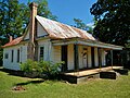 Cuthbert is the birthplace of jazz legend Fletcher Henderson. His birthplace was added to the National Register of Historic Places on June 17, 1982.
 -
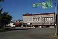 Cuthbert's Main Square is part of the Cuthbert Historic District which was added to the National Register of Historic Places on June 10, 1975.
 -
 Cuthbert City Hall
 -
 Cuthbert Post Office (ZIP code:39840)
 -
 The Old Carnegie library was completed in 1918 and was originally used by the Kinchafoonee Regional Library System. The building is now used by the Randolph Chamber of Commerce.
 -
 Close-up of the statue honoring Confederate dead in Cuthbert's Main Square.
 -
 Water tower in Cuthbert.
 -
 Built in 1886 in the Romanesque Revival style, the Randolph County Courthouse has been placed on the Georgia Trust for Historic Preservation's list of "Places in Peril" for 2012 due to extensive termite damage and general disrepair.
Notable people
- Lena Baker (1900 – 1945), the only woman executed in the electric chair in Georgia; she was later pardoned by the state
- Jerry Braswell Jr. (born 1975), former European professional basketball player and Wake Forest Demon Deacon
- Thomas Davis (born 1983), NFL player, former UGA football player
- Harris DeVane (1963 – 2018), former stock car racing driver
- Roosevelt Grier (born 1932), former NFL player
- Franklin A. Hart (1894 – 1967), four-star general in the United States Marine Corps
- Donnell Harvey (born 1980), former NBA player, former University of Florida player
- Fletcher Henderson (1897 – 1952), influential jazz musician and bandleader
- Larry Holmes (born 1949), former world heavyweight boxing champion
- Dock J. Jordan (1866 – 1943), American lawyer, author, educator, civil rights activist; President of Edward Waters University and Kittrell College
- Winfred Rembert (1945 – 2021), leather-craft artist famous for surviving a lynching in Cuthbert3435
- Willa Holt Wakefield (1870 – 1946), vaudeville performer
- George Tyler Wood (1795 – 1858), second governor of Texas36
- Richard R. Wright Jr. (1878 – 1967), sociologist and president of Wilberforce University.
References
References
- "2020 U.S. Gazetteer Files". United States Census Bureau. Retrieved December 18, 2021.
- "U.S. Census website". United States Census Bureau. Retrieved January 31, 2008.
- "Cuthbert". Geographic Names Information System. United States Geological Survey, United States Department of the Interior. Retrieved February 24, 2026.
- "Find a County". National Association of Counties. Archived from the original on May 31, 2011. Retrieved June 7, 2011.
- "2020 Decennial Census Redistricting Data (Public Law 94-171)". United States Census Bureau. 2021. Retrieved February 4, 2026.
- Krakow, Kenneth K. (1975). Georgia Place-Names: Their History and Origins (PDF). Macon, GA: Winship Press. p. 56. ISBN 0-915430-00-2.
- Gannett, Henry (1905). The Origin of Certain Place Names in the United States. Govt. Print. Off. pp. 98.
- Hellmann, Paul T. (May 13, 2013). Historical Gazetteer of the United States. Routledge. p. 226. ISBN 978-1135948597. Retrieved November 30, 2013.
- "Georgia's rural Black voters helped propel Democrats before. Will they do it again?". NPR.org. Retrieved September 14, 2022.
- "US Gazetteer files: 2010, 2000, and 1990". United States Census Bureau. February 12, 2011. Retrieved April 23, 2011.
- "U.S. Climate Normals Quick Access – Station: Cuthbert, GA". National Oceanic and Atmospheric Administration. Retrieved March 4, 2023.
- "xmACIS2". National Oceanic and Atmospheric Administration. Retrieved March 4, 2023.
- "Decennial Census of Population and Housing by Decade". United States Census Bureau.
- "1870 Census of Population - Georgia - Population of Civil Divisions less than Counties" (PDF). United States Census Bureau. 1870.
- "1880 Census of Population - Georgia - Population of Civil Divisions less than Counties" (PDF). United States Census Bureau. 1880.
- "1910 Census of Population - Georgia" (PDF). United States Census Bureau. 1910.
- "1930 Census of Population - Georgia" (PDF). United States Census Bureau. 1930. pp. 251–256.
- "1940 Census of Population - Georgia" (PDF). United States Census Bureau. 1940.
- "1950 Census of Population - Georgia" (PDF). United States Census Bureau. 1950.
- "1960 Census of Population - Population of County Subdivisions - Georgia" (PDF). United States Census Bureau. 1960.
- "1970 Census of Population - Population of County Subdivisions - Georgia" (PDF). United States Census Bureau. 1970.
- "1980 Census of Population - Number of Inhabitants - Georgia" (PDF). United States Census Bureau. 1980.
- "1990 Census of Population - Summary Social, Economic, and Housing Characteristics - Georgia" (PDF). United States Census Bureau. 1990.
- "2000 Census of Population - General Population Characteristics - Georgia" (PDF). United States Census Bureau. 2000.
- "2010 Census of Population - General Population Characteristics - Georgia" (PDF). United States Census Bureau. 2010.
- "2020 Decennial Census Redistricting Data (Public Law 94-171)". United States Census Bureau. 2021. Retrieved April 28, 2026.
- "2020 Decennial Census Demographic Profile (DP1)". United States Census Bureau. 2021. Retrieved April 28, 2026.
- "2020 Decennial Census Demographic and Housing Characteristics (DHC)". United States Census Bureau. 2023. Retrieved April 28, 2026.
- "Explore Census Data". data.census.gov. Retrieved December 18, 2021.
- "Big Band News", Big Band Library: July 2007
- Georgia Board of Education, Retrieved June 26, 2010.
- School Stats, Retrieved June 26, 2010.
- Andrew College, Retrieved June 26, 2010.
- "Nearly lynched in the 1960s, New Haven man uses art to teach others about the past". FOX 61. March 2, 2017. Retrieved June 29, 2019.
- "The Indelible Images of Winfred Rembert | The Folk Art Society of America". folkart.org. Retrieved June 29, 2019.
- "Texas Governor George T. Wood". National Governors Association. Retrieved November 11, 2013.
External links
External links
- South Georgia Historic Newspapers Archive, Digital Library of Georgia
- The Southern Tribune, office in Cuthbert, GA, local newspaper serving the southwest Georgia counties of Calhoun, Clay, Randolph, and Quitman
- Media related to Cuthbert, Georgia at Wikimedia Commons