| Cowlitz Falls Dam | |
|---|---|
 Cowlitz Falls Hydroelectric Project | |
 Interactive map of Cowlitz Falls Dam | |
| Official name | Cowlitz Falls Hydroelectric Project (FERC No. 2833)1 |
| Country | United States |
| Location | Lewis County, Washington |
| Coordinates | 46°28′00″N 122°06′32″W / 46.46680°N 122.10880°W / 46.46680; -122.10880 |
| Purpose | Power |
| Status | Operational |
| Construction began | June 12, 19912 |
| Opening date |
|
| Built by |
|
| Operator | Lewis County Public Utility District |
| Dam and spillways | |
| Type of dam | Gravity dam |
| Impounds | Cowlitz River |
| Height | 145 ft (44 m)1 |
| Length | 700 ft (210 m) |
| Elevation at crest | 885 ft (270 m) |
| Spillways | 4 |
| Reservoir | |
| Creates | Lake Scanewa |
| Total capacity | 11,000 ac⋅ft1 |
| Catchment area | 1,030 sq mi (2,700 km2)1 |
| Surface area | 700 acres (280 ha) |
| Normal elevation | 866 ft (264 m)3 |
| Power Station | |
| Turbines | 2x 35.0 MW4 |
| Installed capacity | 70 MW4 |
| Annual generation | 196.307 GWh5 |
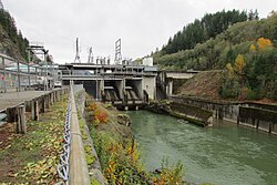
Cowlitz Falls Dam is a 70 megawatt hydroelectric dam in Lewis County, Washington. It was constructed starting in 1991 and completed in 1994. The dam is 145 feet (44 m) high and 700 feet (210 m) long.6
History
A village of the Cowlitz people, known as Koapk, existed at the Cowlitz Falls Dam site. The tribe, possibly Upper Cowlitz, were known as the k’wolama.7
Geography
The dam's reservoir, Lake Scanewa, is located at the confluence of the Cowlitz River and Cispus River downstream of Randle, Washington with a surface area of about 700 acres (280 ha). The lake is accessible by way of the Cowlitz Falls Park, a day use area situated near the junction with the Cispus River.8
Power plant
The Cowlitz Falls Project impounds the Cowlitz River and produces on average 200 gigawatt hours annually for the local public utility, the Lewis County Public Utility District, or about one-third of its annual electrical needs.6 The facility was developed jointly with the Bonneville Power Administration, and the BPA bears the direct cost of operating and maintaining the dam.9
| Generator | Nameplate Capacity (MW)4 |
|---|---|
| U#1 | 35.0 |
| U#2 | 35.0 |
| Total | 70.0 |
Notes
Notes
- Torno-America was the main contractor for dam and powerhouse. 5 other minor contracts were awarded to others.
References
References
- "Document Info for Accession Number: 19940112-0421". eLibrary FERC. Federal Energy Regulatory Commission. Retrieved March 28, 2026.
- "Document Info for Accession Number: 19950207-0106". eLibrary FERC. Federal Energy Regulatory Commission. Retrieved March 28, 2026.
- U.S. Geological Survey Geographic Names Information System: Cowlitz Falls Dam
- "January 2026: EIA 860M". Preliminary Monthly Electric Generator Inventory. U.S. Energy Information Administration. Retrieved March 21, 2026.
- "2024: EIA-923". Form EIA-923 detailed data with previous form data. U.S. Energy Information Administration. Retrieved March 21, 2026.
- "Cowlitz Falls Project". Lewis County PUD. Retrieved July 15, 2012.
- Rochon Wilson, Roy I. (August 31, 2012). "Where and How the Cowlitz Lived". The Chronicle. Retrieved April 10, 2025.
- Rose, Buddy (October 29, 2004). "Coho bring anglers to Lake Scanewa". The Chronicle. Retrieved February 7, 2024.
- "Cowlitz Falls Dam Offline Since January- Page:1". Istockanalyst.com. February 19, 2011. Archived from the original on September 5, 2014. Retrieved July 15, 2012.