Copa
Qupa | |
|---|---|
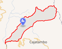 Interactive map of Copa | |
| Country |  Peru Peru |
| Region | Lima |
| Province | Cajatambo |
| Founded | January 2, 1857 |
| Capital | Copa |
| Government | |
| • Mayor | Henoch Flores Callupe (2019-2022) |
| Area | |
• Total | 212.16 km2 (81.92 sq mi) |
| Elevation | 3,410 m (11,190 ft) |
| Time zone | UTC-5 (PET) |
| UBIGEO | 150302 |
Copa District is one of five districts of the province Cajatambo in Peru.1
Geography
The Huayhuash mountain range traverses the district. Some of the highest mountains are listed below:2
Administrative Division
Village centres
- Urban
- Copa, with 481 inhabitants.
- Huayllapa, with 323 inhabitants.
- Rural
Ethnic groups
The people in the province are mainly indigenous citizens of Quechua descent. Quechua is the language 38.52% of the population learnt to speak in childhood, 61.36% of the residents started speaking using the Spanish language (2007 Peru Census).3
References
References
- (in Spanish) Instituto Nacional de Estadística e Informática. Banco de Información Distrital Archived April 23, 2008, at the Wayback Machine. Retrieved April 11, 2008.
- escale.minedu.gob.pe UGEL map of the Cajatambo Province (Lima Region)
- "Censos Nacionales 2017 XI de Población y VI de Vivienda - Perfil Sociodemográfico de la Región Lima" (PDF).
10°23′11″S 77°04′45″W / 10.3864°S 77.0792°W / -10.3864; -77.0792