Chikun | |
|---|---|
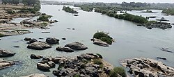 Imagery of Kaduna river along Karji, Chikun | |
| Motto: Home of Peace and Hospitality | |
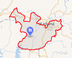 Interactive map of Chikun | |
Chikun | |
| Coordinates: 10°17′06″N 7°06′37″E / 10.285°N 7.1103°E / 10.285; 7.1103 | |
| Country | |
| Local Government Area | |
| State | Kaduna State |
| Headquarters | Kujama |
| Government | |
| • Type | Democracy |
| • Executive Chairman | Samaila Leeman1 |
| Area | |
• Total | 4,466 km2 (1,724 sq mi) |
| Population (2006) | |
• Total | 372,272 |
| • Density | 112.5/km2 (291/sq mi) |
| Time zone | UTC+1 (WAT) |
| ISO 3166 code | NG.KD.CH2 |
Chikun (ⓘ) is a Local Government Area in central Kaduna State, Nigeria. It has an area of about 4,466 km2, and had a population of 372,272 as of the 2006 census.3 Its headquarters is located in the town of Kujama. The postal code of the area is 2438000.4
Boundaries
Chikun Local Government Area (LGA) shares boundaries with Kachia LGA to the south, Kajuru LGA to the east, Kaduna South LGA to the northeast, Igabi LGA to the northeast, Birnin Gwari LGA to the northwest; and Munya LGA to the south and Shiroro LGA to the west, all of Niger State to west, respectively.56
Climate/Geography
In Chikun Local Government Area, the wet season is oppressive and largely cloudy, the dry season is partly gloomy, and it is hot year round. It rarely drops below 21 °F or rises over 25°F throughout the year; instead, the average range of temperatures is 55 °F to 100 °F.78
Chikun Local Government Area has an average yearly temperature of 33 degrees Celsius or 91.4 degrees Fahrenheit and a total area of 4,645 square kilometers (or 1,724 square miles). There are two distinct seasons in the area: the rainy season begins in May and peaks in September, and the dry season runs from October to April.9
Economy
Chikun Local Government Area residents rely primarily on agriculture for their livelihood, with a wide range of crops being farmed there. Weaving textiles, producing mats, and pottery are some of the other significant economic activities in Chikun Local Government Area. There are other markets in the neighborhood, and the trade sector is thriving as well.9
Cultural festival
There are several cultural festivals that are celebrated annually in the Chikun Local Government Area of Kaduna State as found below:10
Kaburu Dance Festival
This festival involves a traditional dance drama by the indigenous Gwari tribe that has to do with performing drama through dancing. At the end of it all, an intended message is passed.
Administrative subdivisions
Chikun Local Government Area consists of 12 subdivisions called Wards (second-order administrative divisions), namely:11
- Chikun ward
- Gwagwada ward
- Kakau ward
- Kujama ward
- Kunai ward
- Kuriga ward
- Narayi ward
- Nassarawa ward
- Rido ward
- Sabon Gari Nassarawa ward
- Sabon Tasha ward
- Yelwa ward
Schools
This area has both public and private schools which are12
History
Chikun Local Government Area derives its name from a Gbagyi village named Chikun in the southeastern part of Kujama. The area was originally populated by the Gbagyi people but is now being subsumed by urbanization making it a cosmopolitan part of Kaduna.
On 5 July 2021, over 100 secondary school pupils from Bethel Baptist Secondary School in Chikun were kidnapped.
Demographics
Population
Chikun Local Government Area according to the March 21, 2006 national population census was put at 372,272.13 Its population was projected by the National Population Commission of Nigeria and National Bureau of Statistics to be 502,500 by March 21, 2016.
People
The indigenous people are the Gbagyi people. They also make up the major population in the area.
Kingship
The traditional ruler is The Esu Chikun, His Royal Highness Isyaku Yari (Sa Gbagy II) Gbagyi. The jurisdiction of the royal Chief covers the entire Chikun Local Government Area and parts of Kaduna South Local Government Area of Television village and Romi New Extension.
References
References
- "NEMA donates relief items to 328 households in parts of Kaduna State". VON. July 16, 2020. Retrieved August 7, 2020.
- HASC, population, area and Headquarters Statoids
- "Kaduna State of Nigeria". City Population. Retrieved February 9, 2021.
- "Post Offices- with map of LGA". NIPOST. Archived from the original on 2009-10-07. Retrieved 2009-10-20.
- "Latest violence in Southern Kaduna Longest on record - Report". Premium Times. February 12, 2017. Retrieved August 1, 2020.
- "Kaduna-State-Political-Map". Voice of Nigeria. Retrieved August 7, 2020.
- "Chikun, Nigeria Hourly Weather Forecast | Weather Underground". www.wunderground.com. Retrieved 2024-08-21.
- "Weather Forecast Chikun - Nigeria (Kaduna) : free 15 day weather forecasts". Weather Crave. 2024-08-21. Retrieved 2024-08-21.
- "Chikun Local Government Area". www.manpower.com.ng. Retrieved 2024-08-21.
- "mindtrip". Mindtrip. Retrieved 2025-08-29.
- "Chikun, Kaduna State, Nigeria". Retrieved September 25, 2020.
- "Factors Militating Against The Introduction Of Computer Education In Secondary Schools: A Case Study Of Five Schools In Chikun Local Government Area Of Kaduna State | Eduprojects.ng". eduprojects.ng. Retrieved 2026-05-30.
- "Kaduna (State, Nigeria) - Population Statistics, Charts, Map and Location". citypopulation.de. Retrieved 2024-10-03.