Chaulieu | |
|---|---|
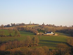 The village of Saint-Martin, the highest point of Manche | |
 Location of Chaulieu | |
Chaulieu Chaulieu | |
| Coordinates: 48°44′10″N 0°51′38″W / 48.7361°N 0.8606°W / 48.7361; -0.8606 | |
| Country | France |
| Region | Normandy |
| Department | Manche |
| Arrondissement | Avranches |
| Canton | Le Mortainais |
| Intercommunality | CA Mont-Saint-Michel-Normandie |
| Government | |
| • Mayor (2020–2026) | Loïc Desdoits1 |
Area 1 | 10.64 km2 (4.11 sq mi) |
| Population (2023)2 | 274 |
| • Density | 25.8/km2 (66.7/sq mi) |
| Time zone | UTC+01:00 (CET) |
| • Summer (DST) | UTC+02:00 (CEST) |
| INSEE/Postal code | 50514 /50150 |
| Elevation | 243–366 m (797–1,201 ft) |
| 1 French Land Register data, which excludes lakes, ponds, glaciers > 1 km2 (0.386 sq mi or 247 acres) and river estuaries. | |
Chaulieu (French pronunciation: [ʃoljø]) is a commune in the Manche department in Normandy in north-western France. It was created in 1973 by the merger of two former communes: Saint-Martin-de-Chaulieu and Saint-Sauveur-de-Chaulieu.3
Geography
The commune is made up of the following collection of villages and hamlets, Saint-Sauveur de Chaulieu, Chaulieu, La Rue, L'Insinière and La Françaisière.4
Chaulieu contains the source of the river Égrenne.5 In addition the river Vire flows through the commune.6
Points of Interest
- Belvédère de Chaulieu is a viewing tower built on the highest point, 368 m (1,207 ft 4 in), of the Manche department7
National Heritage sites
- Château de Chaulieu - a seventeenth Century chateau, which was listed as a Monument historique in 1973.8
References
References
- "Répertoire national des élus: les maires" (in French). data.gouv.fr, Plateforme ouverte des données publiques françaises. 13 September 2022.
- "Populations de référence 2023" (in French). National Institute of Statistics and Economic Studies. 18 December 2025.
- Modifications aux circonscriptions administratives territoriales (fusion de communes), Journal officiel de la République française n° 0014, 17 January 1973, pp. 684-685.
- "Google Maps". Google Maps.
- Sandre. "Fiche cours d'eau - l'Egrenne (M31-0310)".
- Sandre. "Fiche cours d'eau - La Vire (I4--0200)".
- "Belvédère de Chaulieu - CHAULIEU".
- "Château à Chaulieu - PA00110362". Monumentum.