Chassignieu | |
|---|---|
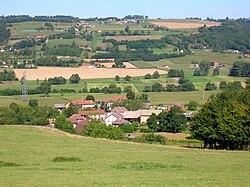 A general view of Chassignieu | |
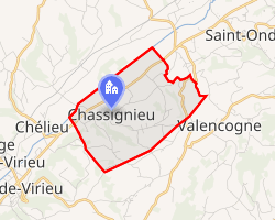 Location of Chassignieu | |
Chassignieu Chassignieu | |
| Coordinates: 45°30′04″N 5°30′19″E / 45.5011°N 5.5053°E / 45.5011; 5.5053 | |
| Country | France |
| Region | Auvergne-Rhône-Alpes |
| Department | Isère |
| Arrondissement | La Tour-du-Pin |
| Canton | Le Grand-Lemps |
| Government | |
| • Mayor (2020–2026) | Jean-Marc Bouvet1 |
Area 1 | 5.17 km2 (2.00 sq mi) |
| Population (2023)2 | 225 |
| • Density | 43.5/km2 (113/sq mi) |
| Time zone | UTC+01:00 (CET) |
| • Summer (DST) | UTC+02:00 (CEST) |
| INSEE/Postal code | 38089 /38730 |
| Elevation | 373–607 m (1,224–1,991 ft) |
| 1 French Land Register data, which excludes lakes, ponds, glaciers > 1 km2 (0.386 sq mi or 247 acres) and river estuaries. | |
Chassignieu (French pronunciation: [ʃasiɲø]) is a commune in the Isère department in southeastern France.
Geography
The Bourbre forms the commune's northwestern border. There is an old and abandoned castle next to the village, the Château de Bellegarde.
Population
| Year | Pop. | ±% p.a. |
|---|---|---|
| 1968 | 239 | — |
| 1975 | 198 | −2.65% |
| 1982 | 190 | −0.59% |
| 1990 | 188 | −0.13% |
| 1999 | 192 | +0.23% |
| 2007 | 201 | +0.57% |
| 2012 | 202 | +0.10% |
| 2017 | 232 | +2.81% |
| 2023 | 225 | −0.51% |
| Source: INSEE3 | ||
References
References
- "Répertoire national des élus: les maires" (in French). data.gouv.fr, Plateforme ouverte des données publiques françaises. 13 September 2022.
- "Populations de référence 2023" (in French). National Institute of Statistics and Economic Studies. 18 December 2025.
- Population municipale entre 1968 et 2023, INSEE