Chépy | |
|---|---|
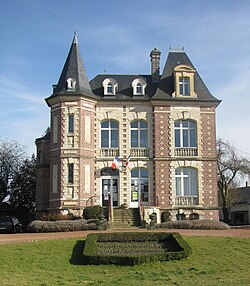 The town hall in Chépy | |
 Coat of arms | |
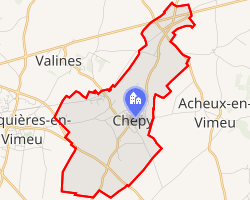 Location of Chépy | |
Chépy Chépy | |
| Coordinates: 50°03′46″N 1°38′51″E / 50.0628°N 1.6475°E / 50.0628; 1.6475 | |
| Country | France |
| Region | Hauts-de-France |
| Department | Somme |
| Arrondissement | Abbeville |
| Canton | Gamaches |
| Intercommunality | CC Vimeu |
| Government | |
| • Mayor (2020–2026) | Denis Vandenbulcke1 |
Area 1 | 7.35 km2 (2.84 sq mi) |
| Population (2023)2 | 1,190 |
| • Density | 162/km2 (419/sq mi) |
| Time zone | UTC+01:00 (CET) |
| • Summer (DST) | UTC+02:00 (CEST) |
| INSEE/Postal code | 80190 /80210 |
| Elevation | 57–111 m (187–364 ft) (avg. 96 m or 315 ft) |
| 1 French Land Register data, which excludes lakes, ponds, glaciers > 1 km2 (0.386 sq mi or 247 acres) and river estuaries. | |
Chépy (French pronunciation: [ʃepi]; Picard: Chpy) is a commune in the Somme department in Hauts-de-France in northern France.3
Geography
The commune is situated on the D465 and D65 crossroads, some 15 km (9 mi) southwest of Abbeville.
Population
| Year | Pop. | ±% p.a. |
|---|---|---|
| 1968 | 860 | — |
| 1975 | 1,083 | +3.35% |
| 1982 | 1,227 | +1.80% |
| 1990 | 1,246 | +0.19% |
| 1999 | 1,277 | +0.27% |
| 2007 | 1,293 | +0.16% |
| 2012 | 1,288 | −0.08% |
| 2017 | 1,252 | −0.57% |
| 2023 | 1,190 | −0.84% |
| Source: INSEE4 | ||
Controversy
The official spelling of the name of the commune is "Chépy" as specified by the Official Geographical Code of the French Republic.3 Some inhabitants in this commune believe the spelling "Chépy" is wrong and should be replaced by "Chepy" and pronounced thus.
References
References
- "Répertoire national des élus: les maires". data.gouv.fr, Plateforme ouverte des données publiques françaises (in French). 2 December 2020.
- "Populations de référence 2023" (in French). National Institute of Statistics and Economic Studies. 18 December 2025.
- Commune de Chépy (80190), INSEE
- Population municipale entre 1968 et 2023, INSEE