Castin | |
|---|---|
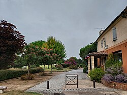 Street of the town hall in Castin. | |
 Coat of arms | |
 Location of Castin | |
Castin Castin | |
| Coordinates: 43°41′31″N 0°32′50″E / 43.6919°N 0.5472°E / 43.6919; 0.5472 | |
| Country | France |
| Region | Occitania |
| Department | Gers |
| Arrondissement | Auch |
| Canton | Gascogne-Auscitaine |
| Intercommunality | CA Grand Auch Cœur Gascogne |
| Government | |
| • Mayor (2020–2026) | Pierrette Luche1 |
Area 1 | 11.22 km2 (4.33 sq mi) |
| Population (2023)2 | 337 |
| • Density | 30.0/km2 (77.8/sq mi) |
| Time zone | UTC+01:00 (CET) |
| • Summer (DST) | UTC+02:00 (CEST) |
| INSEE/Postal code | 32091 /32810 |
| Elevation | 148–266 m (486–873 ft) (avg. 235 m or 771 ft) |
| 1 French Land Register data, which excludes lakes, ponds, glaciers > 1 km2 (0.386 sq mi or 247 acres) and river estuaries. | |
Castin (French pronunciation: [kastɛ̃]) is a commune in the Gers department in southwestern France.
Geography

Population
| Year | Pop. | ±% |
|---|---|---|
| 1962 | 122 | — |
| 1968 | 136 | +11.5% |
| 1975 | 141 | +3.7% |
| 1982 | 188 | +33.3% |
| 1990 | 262 | +39.4% |
| 1999 | 261 | −0.4% |
| 2008 | 268 | +2.7% |
References
References
- "Répertoire national des élus: les maires" (in French). data.gouv.fr, Plateforme ouverte des données publiques françaises. 13 September 2022.
- "Populations de référence 2023" (in French). National Institute of Statistics and Economic Studies. 18 December 2025.