Cape Fugui | |
|---|---|
 Fuguijiao Lighthouse overlooking the point | |
Cape Fugui | |
| Coordinates: 25°17′58″N 121°32′13″E / 25.2995°N 121.5369°E / 25.2995; 121.5369 | |
| Location | Shimen District, New Taipei City, Taiwan |
| Designation | National park |
| Cape Fugui | |||||||||||||||
|---|---|---|---|---|---|---|---|---|---|---|---|---|---|---|---|
 Dapian Point (2015) | |||||||||||||||
| Chinese name | |||||||||||||||
| Traditional Chinese | 富貴角 | ||||||||||||||
| Postal | Fukwei | ||||||||||||||
| Literal meaning | transcription of Dutch hoek, meaning "cape" | ||||||||||||||
| |||||||||||||||
| Japanese name | |||||||||||||||
| Kanji | 富貴角 | ||||||||||||||
| Hiragana | ふうきかく | ||||||||||||||
| |||||||||||||||
| Cape Fugui Park | |||||||||
|---|---|---|---|---|---|---|---|---|---|
 The rocky beach at Fugui Park (2013) | |||||||||
| Traditional Chinese | 富貴角公園 | ||||||||
| |||||||||
Cape Fugui, Cape Fukwei, Fukwei Chiao, Fuguei Cape, or Fugui Cape1 is a cape located at the northernmost point of the island of Taiwan. It is located in Cape Fugui Park within the Shimen District in New Taipei City.
Name
Fùguì is the pinyin romanization of the Mandarin pronunciation of its Chinese name 富貴角. These characters literally mean "rich and noble Cape" but actually transcribe the local Hokkien pronunciation Hù-kùi, used as a transliteration of the Dutch hoek ("hook; cape").2
In the 19th century, it was known as Foki during the period of Qing rule.3 Under Japanese rule, it was known as Fūki Kaku from the Japanese pronunciation of the same characters. During Taiwan's brief official use of Tongyong Pinyin, it was known as Fuguei.4
Geography

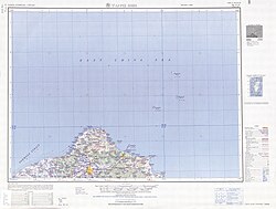
Cape Fugui is the northernmost point of Formosa or Taiwan Island3 and forms one end of Laomei Bay.5
The cape— under its Japanese name "Fuki Kaku"—forms part of the IHO's current definitions of the East67 and South China Seas.8 The still unapproved draft of the 4th edition of the Limits of Oceans and Seas amends the name to its pinyin form Fugui79 but moves the boundary of the South China Sea from Fugui to Taiwan's southern cape Eluan.10
Cape Fugui is also considered part of the northern border of the Taiwan Strait.9
History
The Japanese administration erected a building on the cape in 18961 as the endpoint of an undersea cable.11 It was destroyed during the Second World War. The present lighthouse was erected by the Taiwanese government in 19491 to help guide shipping and received its present black-and-white octagonal tower in 1962.11 It was opened to the public in 2015, but entry is only permitted on the weekends as it remains an active radar station of the Taiwanese Air Force.1
Park
Cape Fugui or Fuguijiao Park surrounds the headland.12 It includes a rocky beach with ventifacts (wind-shaped rocks)12 and lush tropical vegetation.1 There is a walking trail around the cape from Fuji Harbor (t 富基漁港, Fùjī Yúgǎng) to Laomei Village12 and the brick Laomei Maze.1314 Old barracks from the Taiwanese armed forces have been converted into an arts center.11 In September and October, the park forms part of Shimen District's kite festival.12
Transportation
The cape is about 26 kilometers (16 mi) along Provincial Highway 2.1 It is sometimes inaccessible because of rockslides during heavy rain, as during June 2017.15
Gallery
-
 The radar installation at Cape Fugui (2011)
 -
 The sunset over the Taiwan Strait at Fugui (2015)
 -
 Sightseers watching the sunset at Fugui (2015)
References
References
Citations
- NTC (2019), "Fugui Cape".
- Public sign, noted by Caltonhill (2012).
- EB (1879), p. 415.
- Caltonhill (2012).
- NTC (2019), "Fugui Cape Lighthouse".
- IHO (1953), §50.
- IHO (1986), Ch. 7.3.
- IHO (1953), §49.
- IHO (1986), Ch. 7.2.
- IHO (1986), Ch. 6.1.
- "Taiwan's Century-Old Fugueijiao Lighthouse Opened to the Public", Want China Times, 29 September 2015, archived from the original on 27 February 2012, retrieved 14 March 2019.
- NTC (2019), "Fuguijiao Park".
- NTC (2019), "Laomei Maze".
- NTC (2019), "Awesome Positive Energy! A Guide to New Taipei City's 12 Attractions to Improve Your Luck".
- NTC (2019), "Due to recent heavy rain...".
Bibliography
- , Encyclopaedia Britannica, 9th ed., Vol. IX, New York: Charles Scribner's Sons, 1879, pp. 415–17.
- S-23: Limits of Oceans and Seas (PDF) (3rd ed.), Monaco: International Hydrographic Organization, 1953, archived from the original (PDF) on 2011-10-08, retrieved 29 December 2020.
- S-23: Limits of Oceans and Seas (4th (draft) ed.), Monaco: International Hydrographic Organization, 1986, archived from the original on 2016-04-12, retrieved 2019-03-14.
- Official site, New Taipei City: Tourism and Travel Department, 2019.
- Caltonhill, Mark (4 May 2012), "富貴角 Fuguei Cape, New Taipei City", From Takow to Kaohsiung: Exploring Taiwan's History, Culture, and Languages through Its Place Names, Blogspot.