Canisy | |
|---|---|
 | |
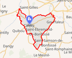 Location of Canisy | |
Canisy Canisy | |
| Coordinates: 49°04′37″N 1°10′28″W / 49.0769°N 1.1744°W / 49.0769; -1.1744 | |
| Country | France |
| Region | Normandy |
| Department | Manche |
| Arrondissement | Saint-Lô |
| Canton | Saint-Lô-2 |
| Intercommunality | Saint-Lô Agglo |
| Government | |
| • Mayor (2020–2026) | Jean-Marie Lebehot1 |
Area 1 | 18.15 km2 (7.01 sq mi) |
| Population (2023)2 | 1,707 |
| • Density | 94.05/km2 (243.6/sq mi) |
| Time zone | UTC+01:00 (CET) |
| • Summer (DST) | UTC+02:00 (CEST) |
| INSEE/Postal code | 50095 /50750 |
| Elevation | 39–116 m (128–381 ft) (avg. 62 m or 203 ft) |
| 1 French Land Register data, which excludes lakes, ponds, glaciers > 1 km2 (0.386 sq mi or 247 acres) and river estuaries. | |
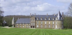
Canisy (French pronunciation: [kanizi]) is a commune in the Manche department in Normandy in north-western France. On 1 January 2017, the former commune of Saint-Ébremond-de-Bonfossé was merged into Canisy.3
Heraldry
 |
The arms of Canisy are blazoned : Vairy Or and gules, on a bend azure, a millrind between 2 horse-brays Or.
|
References
References
- "Répertoire national des élus: les maires". data.gouv.fr, Plateforme ouverte des données publiques françaises (in French). 2 December 2020.
- "Populations de référence 2023" (in French). National Institute of Statistics and Economic Studies. 18 December 2025.
- Arrêté préfectoral 22 July 2016 (in French)