| Camel Trail | |
|---|---|
 The trail beside the Camel Estuary, near Trevanson (1987) | |
 | |
| Length | 18.3 miles (29.5 km), as of 2024 |
| Location | Cornwall, England |
| Trailheads | Padstow,a Wenford Bridgeb |
| Use | Walking, running, cycling, horseriding |
| Grade | 0.23% |
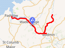
The Camel Trail is a shared-use path in Cornwall, England, available for pedestrians, cyclists, horse riders and wheelchair users. As a rail trail, the route has only a slight incline following the river Camel from Padstow to Wenford Bridge, via Wadebridge and Bodmin, at a total of 18.3 miles (29.5 km) long.
In 2003, 400,000 people were estimated to use the trail each year, generating approximately £3 million per year for the local economy.12 The trail is managed jointly by Cornwall Council and the Camel Trail Partnership.3
History
The trail follows the trackbed of two historic railway lines:
- A section of the North Cornwall Railway between Padstow and Wadebridge
- The Bodmin and Wadebridge Railway (B&WR) between Wadebridge and Wenfordbridge, along with a short branch towards the former Bodmin North station.4
Railway
The Bodmin and Wadebridge Railway was built at a cost of £35,000, following a study commissioned in 1831 by local landowner Sir William Molesworth of Pencarrow. The line was originally used to carry lime-rich sand from the Camel estuary to inland farms for use as fertiliser.567 In 1862, the railway started shipping china clay which, became its most reliable trade.8 Additionally, the line would be used to ship slate from inland quarries to ships in Padstow; it would also transport fish landed in Padstow inland, primarily to London and other large cities.
In 1868, the London and South Western Railway (LSWR) purchased the B&WR without parliamentary consent.68 Although an ultra vires purchase, the acquisition would become legalised in 1886.8 In the interim, the LSWR nonetheless supported the B&WR and sought to connect the isolated railway to its own network via the LSWR-backed North Cornwall Railway.8 The now LSWR-owned NCR line from Halwill Junction reached Wadebridge in June 1895, and then Padstow in March 1899.69
In 1923, as a part of the railways Grouping Act the lines were taken over by Southern Railway, and then again by British Railways (BR) during nationalisation. Under BR, the lines repeatedly changed hands between its Southern and Western Regions, causing management issues.10 As quarrying and fishing diminished, and with greater use of lorries, the railway lost much of its freight traffic; despite this, the line's passenger services continued to be used frequently by holidaymakers and students.1112
As with much of the BR network over the course of the 1960s, services between Padstow and Bodmin's three stations (Bodmin Road, Bodmin General and Bodmin North) were closed under the Beeching Axe; this was an attempt by the UK Government to reduce British Railways' costs and improve its efficiency.512 As a result, passenger services between Bodmin and Padstow were terminated, with the last passenger train running in 1967.7 Freight services continued between Bodmin Road and Wadebridge until 1978.57 The last services on the line to close were the china clay freight services from Wenfordbridge to Bodmin in September 1983.135
Conversion to a trail
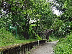
With the cessation of Padstow–Wadebridge services, Cornwall County Council purchased the trackbed from British Railways and in 1980 converted the bed to a public trail.13 Following this, the trackbed of the Wadebridge–Boscarne stretch was also acquired by County Council.
In 1983, Nigel Wiggett opened Bridge Bike Hire in Wadebridge, the first bike hire along the trail and first in the West Country.14 Since then, more bike hire vendors have been established in Wadebridge and these have been joined by others in Padstow, Bodmin and Wendfordbridge.3
After the closure of the Wenford's clay freight services, the North Cornwall District Council (NCDC) acquired the Boscarne–Wenfordbridge trackbed for use as a footpath.13 In 1988, NCDC requested funding to make improvements to the Boscarne–Wenfordbridge stretch so as to integrate it with the rest of the Camel Trail.13
In 1991, the Wadebridge and Egloshayl bypasses were constructed, removing much of the traffic that those passing through Wadebridge along the trail would otherwise have to contend with.
In 2002, the Camel Trail Partnership Trust was established to co-ordinate management of the trail between local town and parish councils along the trail; the NCDC; Cornwall County Council; the Chambers of Commerce of Bodmin, Wadebridge and Padstow; the Environment Agency; English Nature; and the Forestry Commission.2
In 2006, two further extensions to the trail were completed. The first was from Scarlett's Well car park in Bodmin, following into the town.15 The second was from Poley's Bridge, near St Breward, to Wenfordbridge through the old clay dries, which was made possible by Imerys donating the land.
In 2009, Cornwall County Council and the NCDC, along with the rest of Cornwall's district councils, were disbanded and replaced by the new unitary authority, Cornwall Council, which inherited the ownership and responsibilities of the Trail that were held by the County Council and the District Council.316
The trail today
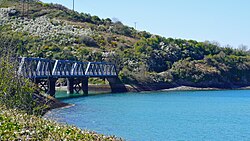
The trail is managed and maintained by Cornwall Council and the Camel Trail Partnership. The bike hire shops operating along the Camel Trail in Padstow, Wadebridge, Bodmin and Wendfordbridge pay an annual licence fee to the council, which is used to help with the trail's maintenance.3
As an erstwhile rail trail, the trackbed was built such that trains would have only a moderate incline and smooth turns, making it suitable as a cycle trail.17 Only a small part of the trail passing through Wadebridge is on roads; it is also infrequently junctioned by rural back roads.3
The Camel Trail shares the Padstow trailhead with the Saints' Way trail. The trail also constitutes part of the National Cycle Network, with the Padstow–Dunmere section a part of Route 3218 and the Bodmin–Wenfordbridge section overlapping with Route 3.19 The trail also constitutes part of The Cornish Way.
Between Wadebridge and Padstow, the trail passes through the Camel Estuary section of the Cornwall National Landscape.320 In this section, about halfway along the track,21 the path passes through the spoil heaps of Camel Quarry. The quarry was in use during the 16th century mining slate22 and made use of an Oatey & Sons steam engine at the time2324
Further proposals
The newly created Bodmin and Wenford Railway sought to reopen the Wenford branch to allow for china clay to again be moved from Wenfordbridge by rail. A separate company, Bodmin and Wenford Rail Freight Limited, was set up in 199225 but the line was not reopened. There were objections from cyclists as, at this point, the track bed had been used for the Camel Trail2627 and the china clay drier closed in 2002.28
Following the closure, attempts at potential expansion has since changed to the route from Boscarne Junction towards Wadebridge, although this route also follows the Camel Trail. The Bodmin and Wenford Rail Freight Company was renamed the Bodmin and Wadebridge Railway Company in 2004 to facilitate this scheme.25 Initially referred to as The Wadebridge Trailway29 it became the RailTrail project in 2008. It was supported by the North Cornwall District Council, but only by a single casting vote; there were objections from cyclists, environmentalists and some residents of Wadebridge. A bid for government funding was made in 2020.30
Scott Mann, Conservative MP for North Cornwall, stated his support for linking up the Camel Trail with the Tarka Trail in September 2020, arguing that it would increase the economic benefits brought in by the Camel Trail.2
Sustrans published a study on 18 December 2020 regarding a potential extension of the Camel Trail from Wenfordbridge to Camelford and on to Delabole. The study also looked at another proposal regarded branch of the Camel Trail from Wadebridge to Launceston, via the North Cornwall Railway trackbed, and on to Lydford, via the Launceston and South Devon Railway trackbed. The study split plans into trail segments, typically between disused stations or towns, and assessed both the feasibility and value of each segment.31
| Deliverability of each segment |
Value of each segment | |
|---|---|---|
| Lower impact | Higher impact | |
| Less challenging deliverability |
|
|
| More challenging deliverability |
|
|
In 2025, Ben Maguire, the Liberal Democrat MP for North Cornwall, stated support for extending the Camel Trail to Camelford.3233 In response to a letter to the Department for Transport calling for it to support the project, he met with Simon Lightwood, the Under-Secretary of State for Local Transport, to discuss the proposal.33 Funding for a feasibility study for the Camelford extension was secured in May 2025.34
See also
See also
Notes
Notes
References
References
- "North Cornwall Matters - Partnership Improves The Trail" (PDF). North Cornwall Matters. North Cornwall District Council. June 2003. p. 3. Archived from the original (PDF) on 23 October 2007. Retrieved 11 October 2007.
- Vergnault, Olivier (17 September 2020). "Huge cycle route would link the Camel Trail with north Devon". Cornwall Live. Retrieved 12 June 2024.
- "The Camel Trail". Cornwall.gov.uk. Retrieved 15 June 2024.
- "Cornwall's iconic Camel Trail had a hidden former life". Cornwall Live. 31 December 2023. Retrieved 16 June 2024.
- "History of the line". BodminRailway.co.uk. Retrieved 12 June 2024.
- "Wadebridge Museum". Wadebridgemuseum.co.uk. Retrieved 12 June 2024.
- Vinter, Jeff (1990). Railway Walks: GWR & SR. The History Press. p. 79. ISBN 978-0-7524-5103-9.
- Vinter 1990, p. 80.
- Vinter 1990, p. 81.
- Vinter 1990, p. 82.
- Vinter 1990, p. 84.
- "Beeching Report proposes closing nearly a third of Britain's 7,000 railway stations". The Times. No. 55661. 28 March 1963. p. 8.
- Vinter 1990, p. 83.
- "40 years of Bike Hire On The Camel Trail". Bridge Bike Hire. Retrieved 16 June 2024.
- "The Camel Trail". Wadebridge-tc.gov.uk. Retrieved 16 June 2024.
- Whitehouse, Richard (29 March 2019). "Council's first 10 years: the controversies, conflicts and Cannes trip". Cornwall Live. Retrieved 16 June 2024.
- "The Camel Trail". Cornwall Guide. 23 February 2013. Retrieved 18 June 2024.
- "Route 32". Sustrans. Retrieved 17 June 2024.
- "Route 3". Sustrans. Retrieved 17 June 2024.
- "Cornwall AONB Management Plan 2022-2027" (PDF). Retrieved 18 June 2024.
- "Camel Quarry, Penquean, St Breock, Cornwall, England". Mindat.org. Retrieved 8 April 2025.
- "Geography Investigation into Tourism in the Camel Estuary" (PDF). Retrieved 8 April 2025.
- Barton, Denys B. (1989). The cornish beam engine: A survey of its history and development in the mines of Cornwall and Devon. Exeter: Cornwall Books. ISBN 978-1-871060-08-9.
- "Oatey and Sons". Gracesguide.co.uk. Retrieved 8 April 2025.
- "Bodmin and Wadebridge Railway Company Limited". Gov.uk. Companies House. Retrieved 2 April 2023.
- "Rough ride for rail". Railwatch. RailFuture. October 1997. Retrieved 2 April 2023.
- Vaughan, John (2002). Branches & Byways - Cornwall. Oxford Publishing Company. p. 107. ISBN 0-86093-566-3.
- "Wenford Dries". Historic England. Retrieved 2 April 2023.
- "The Wadebridge Trailway" (PDF). Bodmin and Wenford Railway. Archived from the original (PDF) on 28 September 2007. Retrieved 3 April 2023.
- Greenaway, Aaron (6 July 2020). "Cornish railway lines axed in Beeching cuts could be restored". Cornwall live. Retrieved 3 April 2023.
- "The North Cornwall Trail". Sustrans. 1 March 2021 [18 December 2020]. Retrieved 7 September 2024.
- Greenaway, Aaron (27 January 2025). "MP issues renewed calls for £11 million scheme to connect Camelford with Camel Trail". Cornwall & Devon Post. Retrieved 26 April 2025.
- McCrum, Kirstie (4 April 2025). "Camel Trail extension on table as local MP meets with minister". Cornwall Live. Retrieved 26 April 2025.
- Melville, Tamsin; Thorpe, George (29 May 2025). "Funding boost for Camel Trail extension project". BBC News. Retrieved 14 June 2025.