| Cailly | |
|---|---|
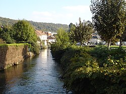 The Cailly at Déville-lès-Rouen | |
| Location | |
| Country | France |
| Physical characteristics | |
| Source | |
| • location | Cailly |
| • elevation | 125 m (410 ft) |
| Mouth | |
• location | The Seine at Rouen |
• coordinates | 49°26′09″N 1°02′43″E / 49.4358°N 1.0453°E / 49.4358; 1.0453 |
• elevation | 4 m (13 ft) |
| Length | 29.3 km (18.2 mi) |
Basin size | 246 km2 (95 sq mi) |
| Discharge | |
| • average | 2.61 m3/s (92 cu ft/s) |
| Basin features | |
| Progression | Seine→ English Channel |
The Cailly (French pronunciation: [kaji]) is a river in Normandy, France, 29 kilometres (18 mi) in length,1 flowing through the department of Seine-Maritime. It is a right tributary of the Seine.
Geography
The Cailly has its source in the territory of the commune of Cailly. Taking a southward journey, it flows through Fontaine-le-Bourg, meeting its principal tributary, the Clérette at Montville. It then flows through Malaunay, Houlme, Notre-Dame-de-Bondeville, Maromme, Déville-lès-Rouen and finally Rouen where it joins the Seine on its right bank.
The average flow of the Cailly at Notre-Dame-de-Bondeville is 2.6 m3 / second.2
History
In the 18th and 19th centuries, the valley was filled with textile mills, which earned it the nickname la petite Manchester, (Little Manchester).
Bibliography
Bibliography
- Albert Hennetier, Aux sources normandes: Promenade au fil des rivières en Seine-Maritime, Ed. Bertout, Luneray, 2006 ISBN 2867436230
References
References
- Sandre. "Fiche cours d'eau - Le Cailly (H5040600)".
- H9913020 Le Cailly à Notre-Dame-de-Bondeville on the Eau France website. Consulted 20 August 2020.