Bylas, Arizona | |
|---|---|
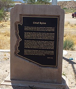 Historic Bylas Town marker | |
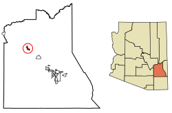 Location of Bylas in Graham County, Arizona. | |
Bylas Bylas | |
| Coordinates: 33°07′45″N 110°07′00″W / 33.12917°N 110.11667°W / 33.12917; -110.11667 | |
| Country | United States |
| State | Arizona |
| County | Graham |
| Indian Reservation | San Carlos Apache Indian Reservation |
| Area | |
• Total | 4.20 sq mi (10.88 km2) |
| • Land | 4.18 sq mi (10.83 km2) |
| • Water | 0.019 sq mi (0.05 km2) |
| Elevation | 2,622 ft (799 m) |
| Population (2020) | |
• Total | 1,782 |
| • Density | 426.2/sq mi (164.55/km2) |
| Time zone | UTC-7 (Mountain (MST)) |
| ZIP code | 855303 |
| Area code | 928 |
| FIPS code | 04-08710 |
| GNIS feature ID | 25827432 |
Bylas (Western Apache: Hago'teełe) is an unincorporated community and census-designated place in Graham County, Arizona, United States, located within the San Carlos Apache Indian Reservation. As of the 2010 census, its population was 1,962.4 The community has a medical clinic, a police substation, and a market. Bylas is an Apache settlement divided into two communities, one of the White Mountain Apache, the other of San Carlos and Southern Tonto Apache. It is named for Bylas (a.k.a. Bailish) a chief of the Eastern White Mountain Apache band.
Demographics
| Census | Pop. | Note | %± |
|---|---|---|---|
| 1960 | 500 | — | |
| 1970 | 1,125 | 125.0% | |
| 1980 | 1,175 | 4.4% | |
| 1990 | 1,219 | 3.7% | |
| 2000 | 1,147 | −5.9% | |
| 2010 | 1,962 | 71.1% | |
| 2020 | 1,782 | −9.2% | |
| U.S. Decennial Census5 | |||
Bylas' population in 1960 was estimated as 500.6
Bylas appeared on the 1970 U.S. Census as an unincorporated village.7 In 1980, it was made a census-designated place (CDP).8
2020 census
As of the 2020 census, Bylas had a population of 1,782.910 The median age was 28.9 years. 34.3% of residents were under the age of 18 and 8.5% of residents were 65 years of age or older. For every 100 females there were 97.6 males, and for every 100 females age 18 and over there were 92.9 males age 18 and over.9
0.0% of residents lived in urban areas, while 100.0% lived in rural areas.11
There were 424 households in Bylas, of which 57.1% had children under the age of 18 living in them. Of all households, 34.2% were married-couple households, 24.5% were households with a male householder and no spouse or partner present, and 33.3% were households with a female householder and no spouse or partner present. About 13.3% of all households were made up of individuals and 3.6% had someone living alone who was 65 years of age or older.9
There were 454 housing units, of which 6.6% were vacant. The homeowner vacancy rate was 0.0% and the rental vacancy rate was 0.0%.9
| Race | Number | Percent |
|---|---|---|
| White | 10 | 0.6% |
| Black or African American | 2 | 0.1% |
| American Indian and Alaska Native | 1,765 | 99.0% |
| Asian | 0 | 0.0% |
| Native Hawaiian and Other Pacific Islander | 0 | 0.0% |
| Some other race | 0 | 0.0% |
| Two or more races | 5 | 0.3% |
| Hispanic or Latino (of any race) | 18 | 1.0% |
2010 census
It appeared normally again as a CDP on the 2010 returns.12
2000 census
In 2000, it did not initially appear on the census returns,13 but the census viewer page14 later returned a population of 1,147.
Transportation
The road is served by U.S. Route 70.
San Carlos Apache Nnee Bich'o Nii Transit provides transportation on the reservation and to Safford and Globe.15 Greyhound Lines serves Bylas on its Phoenix-El Paso via Globe route.
Education
Bylas is served by the Fort Thomas Unified School District.
Notable person
- Chesley Goseyun Wilson, Apache fiddle maker and player, National Heritage Award winner (1989)
Climate
According to the Köppen Climate Classification system, Bylas has a semi-arid climate, abbreviated "BSk" on climate maps.16
References
References
- "2020 U.S. Gazetteer Files". United States Census Bureau. Retrieved October 29, 2021.
- U.S. Geological Survey Geographic Names Information System: Bylas, Arizona
- "Bylas AZ ZIP Code". zipdatamaps.com. 2023. Retrieved February 17, 2023.
- "U.S. Census website". United States Census Bureau. Retrieved May 14, 2011.
- "Census of Population and Housing". Census.gov. Retrieved June 4, 2016.
- "Arizona". World Book Encyclopedia. Vol. A. Chicago: Field Enterprises Educational Corporation. 1960. p. 557.
- Bureau of the Census. "1970 Census of Population - Characteristics of the Population - Arizona" (PDF).
- Bureau of the Census (1980). "Characteristics of the Population - Number of Inhabitants - Arizona" (PDF). United States Census Bureau.
- "2020 Decennial Census Demographic Profile (DP1)". United States Census Bureau. 2021. Retrieved April 30, 2026.
- "2020 Decennial Census Redistricting Data (Public Law 94-171)". United States Census Bureau. 2021. Retrieved April 30, 2026.
- "2020 Decennial Census Demographic and Housing Characteristics (DHC)". United States Census Bureau. 2023. Retrieved April 30, 2026.
- U.S. Census Bureau (October 2012). "Arizona: 2010 - Summary Population and Housing Characteristics" (PDF). U.S. Government Printing Office.
- "Arizona: 2000 - Summary Population and Housing Characteristics" (PDF). Archived from the original (PDF) on October 1, 2019. Retrieved October 11, 2019.
- "Bylas, AZ Population - Census 2010 and 2000 Interactive Map, Demographics, Statistics, Quick Facts - CensusViewer". Archived from the original on June 15, 2013.
- "Globe–Safford Route". Nnee Bich'o Nii Transit. Archived from the original on January 27, 2020. Retrieved January 27, 2020.
- Climate Summary for Bylas, Arizona
External links
External links
- Hometown Locator Bylas
- Epodunk Bylas Archived November 11, 2007, at the Wayback Machine
- USA Cities Online Bylas