Bugweri District | |
|---|---|
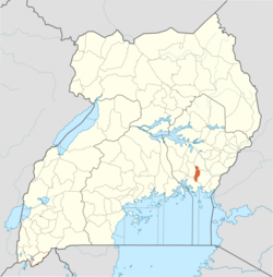 District location in Uganda | |
| Coordinates: 0°38′N 33°37′E / 0.633°N 33.617°E / 0.633; 33.617 | |
| Country |  Uganda Uganda |
| Region | Eastern Uganda |
| Established | 1 July 201823 |
| Area | |
• Total | 378.94 km2 (146.3 sq mi) |
| Population (2024 Census) | |
• Total | 211,5111 |
| Time zone | UTC+3 (EAT) |
| Website | bugweri |
Bugweri District is a district in Busoga region, Eastern Uganda.67
History
Bugweri District was among the new districts approved by Parliament to start operations on 1 July 2018.8 The district was carved out of Iganga District.9
Geography
Bugweri District lies in the Busoga sub-region in Eastern Uganda.10 The district covers about 378.9 km2 and has gently undulating terrain.11
Administrative divisions
Bugweri District has eight lower local government units, five subcounties and three town councils.12
| Unit | Type | Male | Female | Total |
|---|---|---|---|---|
| Ibulanku | Subcounty | 11,341 | 12,434 | 23,775 |
| Igombe | Subcounty | 8,648 | 9,844 | 18,492 |
| Makuutu | Subcounty | 15,630 | 17,689 | 33,319 |
| Buyanga | Subcounty | 20,565 | 22,109 | 42,674 |
| Namalemba | Subcounty | 13,412 | 13,647 | 28,577 |
| Bugweri Town Council | Town council | 8,645 | 10,376 | 19,021 |
| Idudi Town Council | Town council | 10,654 | 13,130 | 23,874 |
| Busembatia Town Council | Town council | 10,188 | 11,681 | 21,869 |
| Total | 99,283 | 112,228 | 211,511 | |
Demographics
At the 2024 census, the district population was 211,511 (99,283 males and 112,228 females).13 The district reported 46,584 households and an average household size of 4.5.14
Economy
Small-scale agriculture is a major livelihood source in the district.15 The district profile lists maize and beans among key crops.16
Social services
Education
The district profile reports 54 government and 147 private primary schools, 8 government and 45 private secondary schools, and 2 tertiary institutions (1 government and 1 private).17
Health
The district profile reports no hospitals, one Health Centre IV, seven Health Centre III facilities, and 21 Health Centre II facilities and clinics, for a total of 29 health facilities across government, PNFP, and private ownership.18
References
References
- "BUGWERI, Population by sex (NPHC 2024)". Uganda Bureau of Statistics, NPHC 2024 Explorer. Retrieved 18 December 2025.
- "Parliament Approves 23 New Districts". Uganda Radio Network. 2016. Retrieved 18 December 2025.
- "Home". Bugweri District Local Government. Retrieved 18 December 2025.
- "District Profile & Facts". Bugweri District Local Government. Retrieved 18 December 2025.
- "Home". Bugweri District Local Government. Retrieved 18 December 2025.
- "NRM releases roadmap for primaries in New districts". PML Daily. 4 August 2018. Retrieved 29 December 2018.
- "NRM set Nov 21 to hold primaries in new districts". Soft Power. 5 November 2018. Retrieved 29 December 2018.
- "Parliament Approves 23 New Districts". Uganda Radio Network. 2016. Retrieved 18 December 2025.
- "Home". Bugweri District Local Government. Retrieved 18 December 2025.
- "Home". Bugweri District Local Government. Retrieved 18 December 2025.
- "District Profile & Facts". Bugweri District Local Government. Retrieved 18 December 2025.
- "District Profile & Facts". Bugweri District Local Government. Retrieved 18 December 2025.
- "BUGWERI, Population by sex (NPHC 2024)". Uganda Bureau of Statistics, NPHC 2024 Explorer. Retrieved 18 December 2025.
- "District Profile & Facts". Bugweri District Local Government. Retrieved 18 December 2025.
- "District Profile & Facts". Bugweri District Local Government. Retrieved 18 December 2025.
- "District Profile & Facts". Bugweri District Local Government. Retrieved 18 December 2025.
- "District Profile & Facts". Bugweri District Local Government. Retrieved 18 December 2025.
- "District Profile & Facts". Bugweri District Local Government. Retrieved 18 December 2025.