| Brane | |
|---|---|
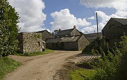 Farm buildings at Brane | |
Brane Location within Cornwall | |
| OS grid reference | SW403284 |
| Civil parish | |
| Unitary authority | |
| Ceremonial county | |
| Region | |
| Country | England |
| Sovereign state | United Kingdom |
| Post town | Penzance |
| Postcode district | TR20 8 |
| Police | Devon and Cornwall |
| Fire | Cornwall |
| Ambulance | South Western |
Brane is a hamlet southwest of Sancreed in west Cornwall, England, UK.1 It is in the civil parish of Sancreed. It is noted for the Carn Euny Iron Age site which lies to the north. Other prehistoric sites nearby include the Iron-Age hill fort of Caer Bran, and chambered tomb known as Brane Barrow.
References
References
- Ordnance Survey: Landranger map sheet 203 Land's End & Isles of Scilly (Map). Ordnance Survey. 2009. ISBN 9780319232897.