| Bosche Range | |
|---|---|
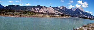 Bosche Range and Athabasca River | |
| Highest point | |
| Peak | Mount Aeolus |
| Elevation | 2,643 m (8,671 ft)1 |
| Listing | Mountains of Alberta |
| Coordinates | 53°16′12″N 118°04′20″W / 53.27000°N 118.07222°W / 53.27000; -118.072222 |
| Dimensions | |
| Length | 40 km (25 mi) N-S3 |
| Width | 28 km (17 mi) E-W3 |
| Area | 483 km2 (186 mi2)3 |
| Geography | |
Bosche Range Location in Western Alberta | |
Country | Canada |
Province | Alberta |
Range coordinates | 53°18′N 118°10′W / 53.300°N 118.167°W / 53.300; -118.1674 |
| Parent range | Canadian Rockies |
| Topo map | NTS 83E8 Rock Lake4 |
The Bosche Range is a mountain range of the Canadian Rockies located northwest of Highway 16 near the eastern border of Jasper National Park, Canada.
This range includes the following mountains and peaks:
| Mountain/Peak | Elevation (m/ft) | |
|---|---|---|
| Roche Ronde | 2,138 | 7,014 |
| Roche à Bosche | 2,123 | 6,965 |
| Coronach Mountain | 2,462 | 8,077 |
| Mount Aeolus | 2,643 | 8,671 |
References
References
- "Mount Aeolus". cdnrockiesdatabases.ca. Retrieved 2021-03-03.
- "Mount Aeolus". Geographical Names Data Base. Natural Resources Canada. Retrieved 2021-03-03.
- "Bosche Range". Peakbagger.com. Retrieved 2012-06-09.
- "Bosche Range". Geographical Names Data Base. Natural Resources Canada. Retrieved 2019-07-24.