Bintan Regency
Kabupaten Bintan | |
|---|---|
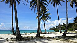 Coconut Trees at Trikora Beach | |
 Seal | |
| Motto: Tak Berganjak - Berat Sama Dipikul, Ringan Sama Dijinjing (Doesn't move - Heavy is the same as being carried, light is the same as being carried) | |
 Location within Riau Islands | |
| Coordinates: 1°01′N 104°33′E / 1.01°N 104.55°E / 1.01; 104.55 | |
| Country | Indonesia |
| Province | Riau Islands |
| Regency seat | Bandar Seri Bentan |
| Government | |
| • Regent | Roby Kurniawan |
| • Vice Regent | Deby Maryanti |
| Area | |
• Total | 1,318.20 km2 (508.96 sq mi) |
| Population (2025 estimate)1 | |
• Total | 182,355 |
| • Density | 138.336/km2 (358.290/sq mi) |
| Time zone | UTC+7 (Indonesia Western Time) |
| Area code | (+62) 770 |
| Website | bintankab.go.id |
Bintan Regency (Indonesian: Kabupaten Bintan; pronounced [kabuˌpat̪ɛn ˈbin̪t̪an]), or originally the Riau Islands Regency23 (Indonesian: Kabupaten Kepulauan Riau; pronounced [kabuˌpat̪ɛn kəpuˌlawan ˈriau̯]) is an administrative area in the Riau Islands Province of Indonesia. Bintan Regency includes all of Bintan Island (except for the city of Tanjung Pinang which is separately administered as an autonomous area of the island) and also includes many outlying islands including the Tambelan and Badas Islands situated between Bintan and West Kalimantan; altogether there are 273 islands comprising the regency.
The Bintan Regency originally included all of the areas now comprising the Riau Islands Province, but on 4 October 1999 parts of the regency were split off to create separate Regencies of Karimun and Natuna (the latter originally including what in 2008 became the Anambas Islands Regency), together with the independent city of Batam. In 2001, the town of Tanjung Pinang on Bintan Island was also split off to become an independent city. In 2002, all these areas which had comprised the original Bintan Regency were brought together in a new Riau Islands Province when that was created from the archipelagic part of Riau Province. In 2003, a further regency – for the Lingga Islands – was created from part of the residual Bintan Regency.
Bintan Regency covers an area of roughly 1,318.20 square kilometres (508.96 mi2). It had a population of 142,300 at the 2010 census4 and 159,518 at the 2020 census;5 the official estimate as at mid 2025 was 182,355 (comprising 93,605 males and 88,750 females).1
Location
The island is located 40 kilometres from Singapore, with an area of 1,467.84 km2, and it had a population of around 330,000 at the 2010 census (including Tanjung Pinang),4 which by the 2020 census had risen to 387,181,5 while the official estimate as of mid 2025 was 423,621 (including Tanjung Pinang's 241,266 residents).1 These area and population figures include the entire Bintan Island as well as outlying islands and archipelagoes that are included within Bintan Regency and Tanjung Pinang City. Famous places in Bintan Regency include Trikora Beach, on the east coast, and the international Bintan Resorts.
Administration
The regency is divided into ten districts (kecamatan) – tabulated below with their areas and their populations at the 20104 and 2020 censuses,5 together with the official estimates as at mid 2025.1 The table also includes the locations of the district administrative centres, the numbers of administrative villages in each district (a total of 36 rural desa and 15 urban kelurahan), and its postal code.
| Kode Wilayah |
Name of district (kecamatan) |
Area in km2 |
Pop'n census 2010 |
Pop'n census 2020 |
Pop'n estimate mid 2025 |
Admin centre |
No. of villages |
Post code |
Names of villages Kelurahan (indicated by asterisk) and Desa |
|---|---|---|---|---|---|---|---|---|---|
| 21.01.08 | Teluk Bintan 6 (Bintan Bay) |
125.44 | 8,934 | 11,367 | 12,125 | Sembeling Tanjung | 6 (a) | 29132 - 29136 |
Bintan Buyu, Pangkil, Penaga, Pengujan, Tembeling, Tembeling Tanjung * |
| 21.01.07 | Bintan Utara 7 (North Bintan) |
43.26 | 21,193 | 22,527 | 25,753 | Tanjung Uban Kota | 5 (b) | 29152 | Tanjung Uban Kota *, Tanjung Uban Utara *, Tanjung Uban Selatan *, Tanjung Uban Timur *, Lancang Kuning |
| 21.01.10 | Teluk Sebong (c) 8 (Sebong Bay) |
285.72 | 16,019 | 18,234 | 20,083 | Sebong Lagoi | 7 (d) | 29154 | Berakit, Ekang Anculai, Pengudang, Sebong Lagoi, Sebang Pereh, Sri Bintan, Kota Baru * |
| 21.01.15 | Seri Kuala Lobam 9 | 123.50 | 17,632 | 17,912 | 20,554 | Teluk Lobam | 5 (e) | 29153 | Busung, Teluk Sasah, Teluk Lobam *, Kuala Sempang, Tanjung Permai " |
| 21.01.06 | Bintan Timur 10 (East Bintan) |
100.18 | 39,006 | 45,929 | 52,389 | Kijang Kota | 4 (f) | 29150 | Kijang Kota *, Sungai Lekop *, Gunung Lengkuas *, Sungai Enam * |
| 21.01.04 | Gunung Kijang 11 | 192.89 | 12,007 | 14,796 | 18,707 | Gunung Kijang | 4 (g) | 29155 | Gunung Kijang, Malang Rapat, Teluk Bacau, Kawal * |
| 21.01.13 | Mantang (h) 12 | 63.61 | 3,896 | 4,162 | 4,629 | Mantang Lama | 4 | 29156 | Mantang Baru, Mantang Besar, Mantang Lama, Dendung |
| 21.01.14 | Bintan Pesisir (i) 13 (Coastal Bintan) |
116.11 | 8,005 | 6,857 | 7,102 | Kelong | 4 | 29151 | Kelong, Mapur, Numbing, Air Gelubi |
| 21.01.12 | Toapaya 14 | 176.48 | 10,633 | 12,843 | 15,575 | Toapaya | 4 (j) | 29157 | Toapaya, Toapaya Utara, Toapaya Selatan, Toapaya Asri * |
| 21.01.09 | Tambelan (k) 15 | 91.02 | 4,975 | 4,891 | 5,438 | Tambelan | 8 (m) | 29193 | Teluk Sekuni *, Batu Lepuk, Kampung Hilir, Kampung Melayu, Pulau Mentebung, Pulau Pinang, Kukup, Pengikik |
| 21.01 | Totals | 1,318.20 | 142,300 | 159,518 | 182,355 | Bintan Buyu | 51 |
Notes:
(a) includes one kelurahan - Tembeling Tanjung. (b) comprises 4 kelurahan (Tanjung Uban Kota, Tanjung Uban Selatan, Tanjung Uban Timur and Tanjung Uban Utara) and 1 desa.
(c) includes virtually all of Bintan Beach International Resort, which covers the entire north of the island. (d) includes one kelurahan - Kota Baru. (e) includes 2 kelurahan (Teluk Lobam and Tanjung Permai).
(f) comprises 4 kelurahan (Gunung Lengkuas, Kijang Kota, Sungai Enam and Sungai Lekop). (g) includes one kelurahan - Kawal.
(h) Mantang District comprises a number of islands lying to the south of Bintan Island, of which the largest are Pulau Mantang, Pulau Senjolong and Pulau Telan, but does not include any part of that island itself.
(i) Bintan Coastal District (kecamatan Bintan Pesisir) comprises numerous islands lying to the east and southeast of Bintan Island, but does not include any part of that island itself. The main islands in the district are Pulau Puto, Pulau Kelong and Pulau Puat (forming a group off Kijang Kota (town) in southern Bintan island); Pulau Gin Besar, Pulau Gin Kecil and Pulau Numbing further to the southeast; and various islands further north including Pulau Pangkil Besar and Pulau Mapur.
(j) includes one kelurahan - Toapaya Asri. (k) Tambelan District comprises the Tambelan Islands and Badas Islands situated between Bintan and West Kalimantan. (m) includes one kelurahan - Teluk Sekuni.
Demography
Religion
Islam is the dominant religion in the city, with 86.88% of the total population identify themselves as Muslim. Other religions are Christianity, which forms 7.52% of the total population, Buddhism, which forms 5.37% of the total population, Hinduism, which forms 0.09% of the total population and Confucianism, which forms 0.38% of the total population.17
Airports
Besides Raja Haji Fisabilillah Airport is near Tanjung Pinang in the south of the island, since 2012 a private company has been building an airport at Lagoi in the north of the island to facilitates tourism with investment $80 to $100 million; it is now predicted to be operational by the end of 2021.18
References
References
- Badan Pusat Statistik, Jakarta, 27 February 2026, Kabupaten Bintan Dalam Angka 2026 (Katalog 1102001.20102)
- "PERATURAN PEMERINTAH REPUBLIK INDONESIA NOMOR 5 TAHUN 2006 TENTANG PERUBAHAN NAMA KABUPATEN KEPULAUAN RIAU MENJADI KABUPATEN BINTAN" (in Indonesian). The Government of Indonesia. Retrieved 23 February 2006.
- "Kabupaten Kepulauan Riau Diubah Menjadi Kabupaten Bintan" (in Indonesian). Tempo.co. 28 February 2006. Retrieved 28 February 2006.
- Biro Pusat Statistik, Jakarta, 2011.
- Badan Pusat Statistik, Jakarta, 2021.
- Badan Pusat Statistik, Jakarta, 26 September 2024, Kecamatan Teluk Bintan Dalam Angka 2024 (Katalog-BPS 1102001.2102040)
- Badan Pusat Statistik, Jakarta, 26 September 2024, Kecamatan Bintan Utara Dalam Angka 2024 (Katalog-BPS 1102001.2102050)
- Badan Pusat Statistik, Jakarta, 26 September 2024, Kecamatan Teluk Sebong Dalam Angka 2024 (Katalog-BPS 1102001.2102051)
- Badan Pusat Statistik, Jakarta, 26 September 2024, Kecamatan Seri Kuala Lobam Dalam Angka 2024 (Katalog-BPS 1102001.2102052)
- Badan Pusat Statistik, Jakarta, 26 September 2024, Kecamatan Bintan Timur Dalam Angka 2024 (Katalog-BPS 1102001.2102060)
- Badan Pusat Statistik, Jakarta, 26 September 2024, Kecamatan Gunung Kujang Dalam Angka 2024 (Katalog-BPS 1102001.2102061)
- Badan Pusat Statistik, Jakarta, 26 September 2024, Kecamatan Mantang Dalam Angka 2024 (Katalog-BPS 1102001.2102062)
- Badan Pusat Statistik, Jakarta, 26 September 2024, Kecamatan Bintan Pesisir Dalam Angka 2024 (Katalog-BPS 1102001.2102063)
- Badan Pusat Statistik, Jakarta, 26 September 2024, Kecamatan Toapaya Dalam Angka 2024 (Katalog-BPS 1102001.2102064)
- Badan Pusat Statistik, Jakarta, 26 September 2024, Kecamatan Tambelan Dalam Angka 2024 (Katalog-BPS 1102001.2102070)
- "Religion in Indonesia".
- "Riau Islands Province in Figures 2017". BPS Kepulauan Riau. Retrieved 22 July 2018.
- "Kepri Akan Bangun Bandara Internasional di Lagoi". 20 March 2012. Archived from the original on 23 April 2012. Retrieved 20 March 2012.