Bhedetar
भेडेटार | |
|---|---|
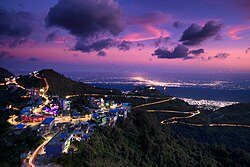 Evening view of Bhedetar, the hill station of Nepal | |
Bhedetar Location in Nepal | |
| Coordinates: 26°53′0″N 87°20′0″E / 26.88333°N 87.33333°E / 26.88333; 87.33333 | |
| Country |  Nepal Nepal |
| Province | Koshi Province |
| District | Dhankuta |
| Area | Sangurigadhi |
| Elevation | 1,420 m (4,660 ft) |
| Population (2011) | |
• Total | 2,977 |
| Time zone | UTC+5:45 (NST) |
| Postal code | 56804 |
| Area code | 026 |
| Nearest city | Dharan |
Bhedetar (translation: Sheep's Butte) is a village development committee in Dhankuta District in the Koshi Province of eastern Nepal. The main settlement began when the Dharan - Dhankuta Highway was completed in 1982. At the time of the 1991 Nepal census it had a population of 2643 people living in 513 individual households.1 It is 1,420 meters above sea level. It is actually on the border line of Sunsari and Dhankuta districts.
Attractions
Bhedetar is a developing tourist spot. It is a small hill station just 16 kilometers away from Dharan Sub-metropolis. it is also known as a transit point to the Namaste Jharna, which is a waterfall.
Nepal Television has a high power transmitter station at Bhedetar which broadcasts different channels. Transmissions are not only received in Bhedetar but also neighbouring places.

References
References
- "Nepal Census 2001". Nepal's Village Development Committees. Digital Himalaya. Archived from the original on 12 October 2008. Retrieved 24 November 2008.