Bhattiprolu | |
|---|---|
Village | |
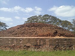 Buddhist Maha Stupa at Bhattiprolu | |
 Interactive map of Bhattiprolu | |
Bhattiprolu Location in Andhra Pradesh, India Show map of IndiaBhattiprolu Bhattiprolu (Andhra Pradesh) Show map of Andhra Pradesh | |
| Coordinates: 16°06′09″N 80°46′51″E / 16.1026°N 80.7807°E / 16.1026; 80.7807 | |
| Country | India |
| State | Andhra Pradesh |
| District | Bapatla |
| Mandal | Bhattiprolu |
| Government | |
| • Type | Panchayati raj |
| • Body | Bhattiprolu Gram Panchayat |
| Area | |
• Total | 2,515 ha (6,210 acres) |
| Population (2011)3 | |
• Total | 11,092 |
| • Density | 441.0/km2 (1,142/sq mi) |
| Languages | |
| • Official | Telugu |
| Time zone | UTC+5:30 (IST) |
| PIN | 522256 |
| Area code | +91– |
| Vehicle registration | AP |

Bhattiprolu is a village in Bapatla district of the Indian state of Andhra Pradesh. It is the headquarters of Bhattiprolu mandal in Repalle revenue division.4 The Buddhist stupa in the village is one of the centrally protected monuments of national importance.5 One of the earliest evidence of Brahmi script in South India comes from Bhattiprolu.6 The script was written on an urn containing Shakyamuni Buddha's relics. The script has been named Bhattiprolu script.
History
The original name of Bhattiprolu was Pratipalapura, a flourishing town in the ancient Sala kingdom that predated Andhra Satavahanas. From available inscriptional evidence, King Kuberaka was ruling over Bhattiprolu around 230 BCE. Bhattiprolu is well known for its Buddha stupa (Vikramarka kota dibba) built about 3rd-2nd century BCE.
Geography
It is spread over an area of 2,515 ha (6,210 acres).2
Government and politics
Bhattiprolu gram panchayat is the local self-government of the village.78 The village forms a part of Andhra Pradesh Capital Region and is under the jurisdiction of APCRDA.9
Transport
The village has connectivity with National Highway 216 (India) which passes through the village. APSRTC operates buses from Tenali and Repalle via Bhattiprolu. Bhattiprolu railway station is located on Tenali–Repalle branch line and administered under Guntur railway division of South Central Railway zone.10
Education
As per the school information report for the academic year 2018–19, the village has a total of 14 schools. These include 4 MPP, one other type and 9 private schools.11
References
References
- "Gram Panchayat Identification Codes" (PDF). Saakshar Bharat Mission. National Informatics Centre. p. 98. Archived from the original (PDF) on 18 August 2017. Retrieved 9 May 2019.
- "District Census Hand Book : Guntur (Part B)" (PDF). Census of India. Directorate of Census Operations, Andhra Pradesh. 2011. pp. 14, 474. Retrieved 2 June 2019.
- "Population". Census of India. Registrar General and Census Commissioner of India. Retrieved 9 May 2019.
- "District Census Handbook : Guntur (Part A)" (PDF). Census of India. Directorate of Census Operations, Andhra Pradesh. 2011. pp. 5, 782–783. Retrieved 3 June 2019.
- "Centrally Protected Monuments". Archeological Survey of India. Archived from the original on 26 June 2017. Retrieved 27 May 2017.
- Ananda Buddha Vihara Archived 2007-09-30 at the Wayback Machine
- "Gram Panchayat Identification Codes" (PDF). Saakshar Bharat Mission. p. 97. Archived from the original (PDF) on 5 July 2016. Retrieved 5 July 2016.
- "Bhattiprolu Village Panchayat". National Panchayat Portal. Archived from the original on 20 October 2020. Retrieved 6 May 2016.
- "Declaration of A.P. Capital Region" (PDF). Andhra Pradesh Capital Region Development Authority. Municipal Administration and Urban Development Department, Andhra Pradesh. 30 December 2014. p. 5. Archived from the original (PDF) on 11 May 2019. Retrieved 14 May 2019.
- "Map of Bhattiprolu". Indiarailinfo. Retrieved 12 December 2014.
- "School Information". Commissionerate of School Education. Government of Andhra Pradesh. Archived from the original on 16 April 2019. Retrieved 7 May 2019.