Beydağ | |
|---|---|
District and municipality | |
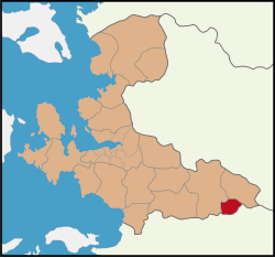 Map showing Beydağ District in İzmir Province | |
Beydağ Location in Turkey Show map of TurkeyBeydağ Beydağ (İzmir) Show map of İzmir | |
| Coordinates: 38°05′N 28°14′E / 38.083°N 28.233°E / 38.083; 28.233 | |
| Country | Turkey |
| Province | İzmir |
| Government | |
| • Mayor | Feridun Yılmazlar (CHP) |
Area | 172 km2 (66 sq mi) |
| Population (2022)1 | 12,030 |
| • Density | 69.9/km2 (181/sq mi) |
| Time zone | UTC+3 (TRT) |
| Postal code | 35790 |
| Area code | 0232 |
| Website | www |
Beydağ (Turkish: [ˈbejdaː]) is a municipality and district of İzmir Province, Turkey.2 Its area is 172 km2,3 and its population is 12,030 (2022).1
Composition
There are 25 neighbourhoods in Beydağ District:4
- Adaküre
- Aktepe
- Alakeçili
- Atatürk
- Bakırköy
- Beyköy
- Çamlık
- Çiftlikköy
- Çomaklar
- Cumhuriyet
- Eğridere
- Erikli
- Halıköy
- Karaoba
- Kurudere
- Menderes
- Mutaflar
- Palamutçuk
- Sarıkaya
- Tabaklar
- Yağcılar
- Yeniyurt
- Yeşiltepe
- Yukarı Aktepe
- Yukarı Tosunlar
References
References
- "Address-based population registration system (ADNKS) results dated 31 December 2022, Favorite Reports" (XLS). TÜİK. Retrieved 12 July 2023.
- Büyükşehir İlçe Belediyesi Archived 2023-03-06 at the Wayback Machine, Turkey Civil Administration Departments Inventory. Retrieved 12 July 2023.
- "İl ve İlçe Yüz ölçümleri". General Directorate of Mapping. Retrieved 12 July 2023.
- Mahalle Archived 2023-03-06 at the Wayback Machine, Turkey Civil Administration Departments Inventory. Retrieved 12 July 2023.