Berthierville | |
|---|---|
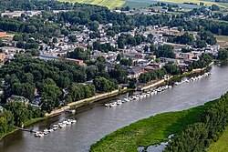 | |
 Coat of arms | |
 Location within D'Autray RCM | |
Berthierville Location in central Quebec | |
| Coordinates: 46°05′N 73°11′W / 46.083°N 73.183°W / 46.083; -73.1831 | |
| Country | Canada |
| Province | Quebec |
| Region | Lanaudière |
| RCM | D'Autray |
| Constituted | April 14, 1852 |
| Government | |
| • Mayor | Pierre Lahaie |
| • Federal riding | Berthier—Maskinongé |
| • Prov. riding | Berthier |
| Area | |
• Total | 7.22 km2 (2.79 sq mi) |
| • Land | 6.77 km2 (2.61 sq mi) |
| Population (2021)3 | |
• Total | 4,386 |
| • Density | 647/km2 (1,680/sq mi) |
| • Change 2016-21 |  4.7% 4.7% |
| • Dwellings | 2,225 |
| Time zone | UTC−5 (EST) |
| • Summer (DST) | UTC−4 (EDT) |
| Postal code(s) | |
| Area codes | 450 and 579 |
Highways  A-40 A-40 |  R-138 R-138  R-158 R-158 |
| Website | www |
Berthierville (/ˈbɛərtjeɪvɪl/;4 French pronunciation: [bɛʁtjevil]; also called Berthier-en-haut, and legally called Berthier before 1942) is a town located between Montreal and Trois-Rivières on the north shore of the St. Lawrence River in Quebec, Canada. Berthierville is the seat of D'Autray Regional County Municipality, and is served by Autoroute 40, and is the junction of Routes 138 and 158. The town is listed as a Village rélais.5 It is surrounded by the parish municipality of Sainte-Geneviève-de-Berthier.
The Marie Reine du Canada Pilgrimage column stops at the church of Sainte-Geneviève de Berthierville for Mass on the first day of its three-day walk from Lanoraie to Cap-de-la-Madeleine.
History

In 1672, the area was granted as a seignory by Jean Talon, intendant of New France, to Hugues Randin, who in turn sold it to Alexandre Berthier the following year.6 This seignory became known as Berthier-en-Haut (Upper Berthier) to distinguish it from another seignory that Berthier owned in the Bellechasse region.7
In 1845, the Municipality of Berthier-en-Haut was formed, but abolished in 1847. It was reestablished as the Village Municipality of Berthier in 1852, and changed status to ville in 1865. In 1942, it was renamed to Berthierville.1
In 1962, Berthierville annexed part of Sainte-Geneviève-de-Berthier.8
Demographics
In the 2021 Census of Population conducted by Statistics Canada, Berthierville had a population of 4,386 living in 2,166 of its 2,225 total private dwellings, a change of 4.7% from its 2016 population of 4,189. With a land area of 6.77 km2 (2.61 sq mi), it had a population density of 647.9/km2 (1,677.9/sq mi) in 2021.3
Historical census populations – Berthierville | ||||||||||||||||||||||||||||||||||||||||||||||||||||||||||||||||||||||||||||||||
|
|
| ||||||||||||||||||||||||||||||||||||||||||||||||||||||||||||||||||||||||||||||
| Population counts are not adjusted for boundary changes. Source: Statistics Canada39108 | ||||||||||||||||||||||||||||||||||||||||||||||||||||||||||||||||||||||||||||||||
Mother tongue (2021):3
- English as first language: 0.8%
- French as first language: 95.5%
- English and French as first languages: 0.8%
- Other as first language: 2.5%
Education
Centre de services scolaire des Samares, formerly the Commission scolaire des Samares, operates francophone public schools, including:
- École secondaire Pierre-de-Lestage
- École du Chemin-du-Roy
- École de l'Île Saint-Ignace (currently in Berthierville)14
The Sir Wilfrid Laurier School Board operates anglophone public schools, including:
- Joliette Elementary School in Saint-Charles-Borromée15
- Joliette High School in Joliette16
Notable people
- Alexis St. Martin, Gastrointestinal experimentation pioneer
- Gilles Villeneuve, Formula One race car driver
- Jacques Villeneuve (born 1953), Formula 1 driver
- Aristide Blais, Canadian Senator for Alberta
- Richard Landry, architect
References
References
- "Banque de noms de lieux du Québec: Reference number 5375". toponymie.gouv.qc.ca (in French). Commission de toponymie du Québec.
- "Répertoire des municipalités: Geographic code 52035". www.quebec.ca (in French). Gouvernement du Québec.
- "Berthierville (Code 2452035) Census Profile". 2021 census. Government of Canada - Statistics Canada. Retrieved 2026-07-03.
- The Canadian Press (2017), The Canadian Press Stylebook (18th ed.), Toronto: The Canadian Press
- "Villages-relais | Québec 511". www.quebec511.info.
- "Histoire et patrimoine". www.ville.berthierville.qc.ca (in French). Ville de Berthierville. Retrieved 3 July 2026.
- "Banque de noms de lieux du Québec: Berthier-sur-Mer". toponymie.gouv.qc.ca (in French). Commission de toponymie du Québec. Retrieved 2026-07-03.
- "1971 Census of Canada - Population Census Subdivisions (Historical)". Catalogue 92-702 Vol I, part 1 (Bulletin 1.1-2). Statistics Canada. July 1973.
- Statistics Canada 2011 Census - Berthierville census profile
- Eighth Census of Canada 1941 - Volume II - Population by Local Subdivisions (Report). Dominion Bureau of Statistics. 1944. CS98-1941-2.
- "du Chemin-du-Roy (pavillon maternelle Sainte-Geneviève) Archived 2017-09-22 at the Wayback Machine." Commission scolaire des Samares. Retrieved on September 22, 2017.
- "du Chemin-du-Roy (pavillon Sainte-Geneviève) Archived 2017-09-22 at the Wayback Machine." Commission scolaire des Samares. Retrieved on September 22, 2017.
- "du Chemin-du-Roy (pavillon Saint-Joseph) Archived 2017-09-22 at the Wayback Machine." Commission scolaire des Samares. Retrieved on September 22, 2017.
- "École de l'Île Saint-Ignace Archived 2017-09-22 at the Wayback Machine." Commission scolaire des Samares. Retrieved on September 22, 2017.
- "JOLIETTE ELEMENTARY ZONE Archived 2017-09-17 at the Wayback Machine." Sir Wilfrid Laurier School Board. Retrieved on September 17, 2017.
- "Joliette High School Zone Sec 1-5 Archived 2017-09-04 at the Wayback Machine." Sir Wilfrid Laurier School Board. Retrieved on September 5, 2017.