Beomseo
범서읍 凡西邑 | |
|---|---|
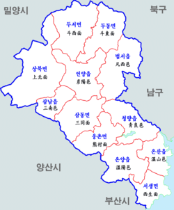 Map of Ulju County. Beomseo is depicted in the northeast. | |
Beomseo Location within Ulsan Show map of UlsanBeomseo Location within South Korea Show map of South Korea | |
| Coordinates: 35°35′49″N 129°14′48″E / 35.59694°N 129.24667°E / 35.59694; 129.24667 | |
| Country |  South Korea South Korea |
| Province | Ulsan |
| County | Ulju |
| Area | |
• Total | 77.1 km2 (29.8 sq mi) |
| Elevation | 113 m (371 ft) |
| Population (2023) | |
• Total | 68,051 |
| • Density | 883/km2 (2,290/sq mi) |
Beomseo (Korean: 범서읍) is an eup of Ulju County, Ulsan, South Korea. It is located to the east of Muhak Mountain, at an average elevation of 133 meters above the sea level.1 As of the year 2023, it had a total population of 68,051.2
Administrative divisions
As of February 2023, Beomseo consists of 10 villages, called ri. They are:3
| Map | |||
|---|---|---|---|
 | |||
| Villages | Hangul | Hanja | Population |
| Guyeong-ri | 구영리 | 九英里 | 30,016 |
| Cheonsang-ri | 천상리 | 川上里 | 19,940 |
| Gulhwa-ri | 굴화리 | 屈火里 | 15,746 |
| Cheokgwari-ri | 척과리 | 尺果里 | 976 |
| Doosan-ri | 두산리 | 斗山里 | 641 |
| Seosa-ri | 서사리 | 西砂里 | 164 |
| Ipam-ri | 입암리 | 立岩里 | 352 |
| Sayeon-ri | 사연리 | 泗淵里 | 272 |
| Jung-ri | 중리 | 中里 | 254 |
| Mangseong-ri | 망성리 | 望星里 | 251 |
References
References
- "Beomseo-eup topographic map, elevation, terrain". Topographic maps. Retrieved 27 February 2024.
- "KOSIS". kosis.kr. Retrieved 27 February 2024.
- "범서읍 현황" [Current status of Beomseo-eup]. www.ulju.ulsan.kr (in Korean). Retrieved 27 February 2024.