| Benaize | |
|---|---|
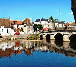 The Benaize at La Trimouille | |
| Location | |
| Country | France |
| Physical characteristics | |
| Source | |
| • location | La Souterraine |
| • coordinates | 46°14′43″N 01°27′46″E / 46.24528°N 1.46278°E / 46.24528; 1.46278 |
| • elevation | 385 m (1,263 ft) |
| Mouth | |
• location | Anglin |
• coordinates | 46°34′26″N 01°04′06″E / 46.57389°N 1.06833°E / 46.57389; 1.06833 |
• elevation | 85 m (279 ft) |
| Length | 79 km (49 mi) |
Basin size | 582 km2 (225 sq mi) |
| Discharge | |
| • average | 5 m3/s (180 cu ft/s) |
| Basin features | |
| Progression | Loire→ Atlantic Ocean |
The Benaize (French pronunciation: [bənɛz]; Occitan: Benesa, Beneisa or Benaisa) is a 79-kilometre (49 mi) long river in the Creuse, Haute-Vienne, Vienne and Indre departments, central France.1 Its source is near La Souterraine. It flows generally northwest. It is a left tributary of the Anglin, into which it flows north of Saint-Hilaire-sur-Benaize.
Departments and communes along its course
This list is ordered from source to mouth:
- Creuse: La Souterraine
- Haute-Vienne: Arnac-la-Poste
- Creuse: Vareilles
- Haute-Vienne: Saint-Sulpice-les-Feuilles, Mailhac-sur-Benaize, Cromac, Jouac, Saint-Martin-le-Mault
- Indre: Bonneuil, Tilly
- Haute-Vienne: Lussac-les-Églises
- Vienne: Coulonges, Brigueil-le-Chantre, Thollet La Trimouille Liglet
- Indre: Saint-Hilaire-sur-Benaize