| Bebrava | |
|---|---|
 | |
| Location | |
| Country | Slovakia |
| Physical characteristics | |
| Mouth | Nitra |
• location | Topoľčany |
• coordinates | 48°34′13″N 18°12′33″E / 48.5704°N 18.2092°E / 48.5704; 18.2092 |
| Length | 46.7 km (29.0 mi) |
Basin size | 631 km2 (244 sq mi) |
| Basin features | |
| Progression |
Váh→ Danube→ Black Sea |
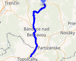
The Bebrava is a river in western Slovakia. It rises in the Strážovské vrchy mountains near the village of Čierna Lehota, flowing at first south-west, turning after some 10 km into south, flowing through Bánovce nad Bebravou, finally pouring into the river Nitra near Topoľčany. It is 47 km (29 mi) long and its basin size is 631 km2 (244 sq mi).1
References
References
- Plán manažmentu povodňového rizikavčiastkovom povodí Váhu Archived 2021-10-04 at the Wayback Machine, p. 72