Native name: 匙洲 | |
|---|---|
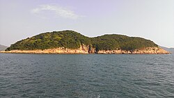 Bay Islet as seen from the West | |
Location within Hong Kong | |
| Geography | |
| Coordinates | 22°20′8.2″N 114°20′1.9″E / 22.335611°N 114.333861°E / 22.335611; 114.333861 |
| Area | 0.08 km2 (0.031 sq mi) |
| Administration | |
| Districts | Sai Kung District |

Bay Islet or See Chau (Chinese: 匙洲) is an uninhabited island in Sai Kung District, Hong Kong.
Geography
Bay Islet is located in Rocky Harbour,1 also known as Leung Shuen Wan Hoi, and is separated from Jin Island by the See Chau Mun (匙洲門) channel. The island has a maximum elevation of 44.8 m and an area of 8 hectares.2
References
References
- "hk-place.com". Archived from the original on 2021-04-25. Retrieved 2016-07-24.
- Hu, Puwei; Xing, Fuwu; Chen, Lin; Wang, Meina; Wang, Faguo; Chen, Hongfeng (2011). "Vegetation and vascular plant diversity of islands surrounding Port Shelter, Hong Kong, China". Biodiversity Science. Vol. V19 (05). pp. 605–609. Archived from the original on 1 December 2015.