Barentin | |
|---|---|
 Viaduct | |
 Coat of arms | |
 Location of Barentin | |
Barentin Barentin | |
| Coordinates: 49°33′N 0°57′E / 49.55°N 0.95°E / 49.55; 0.95 | |
| Country | France |
| Region | Normandy |
| Department | Seine-Maritime |
| Arrondissement | Rouen |
| Canton | Barentin |
| Government | |
| • Mayor (2020–2026) | Christophe Bouillon1 |
Area 1 | 12.74 km2 (4.92 sq mi) |
| Population (2023)2 | 12,022 |
| • Density | 943.6/km2 (2,444/sq mi) |
| Time zone | UTC+01:00 (CET) |
| • Summer (DST) | UTC+02:00 (CEST) |
| INSEE/Postal code | 76057 /76360 |
| Elevation | 30–128 m (98–420 ft) (avg. 75 m or 246 ft) |
| 1 French Land Register data, which excludes lakes, ponds, glaciers > 1 km2 (0.386 sq mi or 247 acres) and river estuaries. | |
Barentin (French pronunciation: [baʁɑ̃tɛ̃]) is a commune in the Seine-Maritime department in the Normandy region in northern France.
Geography
The town is situated in the valley of the Austreberthe, a small affluent of the Seine.3 It is a town of light industry and farming situated by the banks of the river Austreberthe in the Pays de Caux, some 10 miles (16 km) northwest of Rouen at the junction of the D6015, D143 and the D104 roads. SNCF operates a TER rail service here.
Heraldry
|
The arms of Barentin are blazoned : Azure, a viaduct argent masonned sable, and in chief 3 bees Or.
|
Population
|  | |||||||||||||||||||||||||||||||||
Places of interest
- The church of St.Martin, dating from the nineteenth century.
- A museum.
- A seventeenth century fountain on the town square.
- More than 200 statues in the town, by Rodin, Janniot, Bourdelle, Drivier, Frémiet, Lagriffoul, etc.
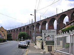
- The railway viaduct, constructed in 1847 by Joseph Locke, with 27 arches 33m high.
- The sixteenth century chapel of Saint-Hélier.
Notable people
- André Marie, politician (1897–1974)
- Père Jacques (born Lucien Bunel), (1900–1945), priest of the Carmelite Order, Righteous Among the Nations
International relations
Barentin is twinned with:
 Petersfield, Hampshire in the United Kingdom56
 Warendorf in Germany
 Castiglione delle Stiviere in Italy
 Brossard, Quebec in Canada
References
References
- Émile Lefort, Barentin autrefois, aujourd'hui, Rouen, 1933 ISBN 2-84373-627-7
- "Répertoire national des élus: les maires" (in French). data.gouv.fr, Plateforme ouverte des données publiques françaises. 13 September 2022.
- "Populations de référence 2023" (in French). National Institute of Statistics and Economic Studies. 18 December 2025.
- Chisholm, Hugh, ed. (1911). . Encyclopædia Britannica. Vol. 3 (11th ed.). Cambridge University Press. p. 414.
- Population municipale entre 1968 et 2023, INSEE
- Chapman, Phil (May 2006). "Petersfield Twinning Association". Hampshire County Council. Retrieved 2013-07-25.
- "British towns twinned with French towns [via WaybackMachine.com]". Archant Community Media Ltd. Archived from the original on 5 July 2013. Retrieved 2013-07-20.