| Barail Range | |
|---|---|
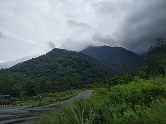 The Assam section of the Barail Range | |
| Highest point | |
| Peak | Mount Japfü |
| Elevation | 3,048 m (10,000 ft) |
| Coordinates | 25°16′27″N 93°20′51″E / 25.27417°N 93.34750°E / 25.27417; 93.34750 |
| Dimensions | |
| Length | 720 km (450 mi) |
| Geography | |
 | |
Country | India |
States | Assam, Meghalaya, Manipur and Nagaland |
Region | Northeast India |
Rivers | Barak, Brahmaputra and Kopili |
Settlements | Dima Hasao, Kohima, Shillong, Diphu and Silchar |
Range coordinates | 25°00′N 93°30′E / 25°N 93.5°E / 25; 93.5 |
| Geology | |
| Orogeny | Himalayan Orogeny |
| Rock type | Sandstone |
The Barail Range is a tertiary mountain range in Northeast India with an area of approximately 80,000 ha between Brahmaputra and Barak basins stretching from Nagaland & Manipur to the east and Assam & Meghalaya to the west.12
Highest Peak is Mount Japfü (3,048 m) in Nagaland. Other notable peaks are Laike (1,959 m), Theipibung (1,866m), Mahadevi (1,739m) and Kaukaha (1,736m).
References
References
- "BirdLife Data Zone". datazone.birdlife.org. Retrieved 9 January 2021.
- saikia, partha; protim. "Barail Range of Assam | Mountain of Assam". NORTH EAST INDIA IN DETAILS. Retrieved 9 January 2021.