| Manavadar State Bantva Manavadar | |||||||
|---|---|---|---|---|---|---|---|
| Princely State | |||||||
| 1733–1947 | |||||||
 Flag | |||||||
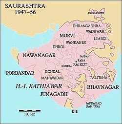 | |||||||
| Location of Manavadar State at the southern end of Saurashtra | |||||||
| Area | |||||||
• 1941 | 261.6 km2 (101.0 sq mi) | ||||||
| Population | |||||||
• 1941 | 26,209 | ||||||
| History | |||||||
• Established | 1733 | ||||||
• Disestablished | 1947 | ||||||
| |||||||


Bantva-Manavadar or Manavadar State was a princely state during the era of the British Raj in India. It was located on the Kathiawar peninsula in Gujarat.1
The decision in 1947 of the ruling prince, Muhammad Mahabat Khan III, to accede Junagadh and Bantva Manavadar as princely states of Pakistan led to a crisis, as most of his subjects were Hindus. In February 1948 came the Annexation of Junagadh and Bantva Manavadar by India, following a referendum.23
References
References
- Gazetteer of the Bombay Presidency: Kathiawar (Public Domain text). Vol. VIII. Printed at the Government Central Press, Bombay. 1884. pp. 377–378.
- Srinath Raghavan, War and Peace in Modern India (2010), p. 63
- Rajmohan Gandhi, Patel: A Life (India: Navajivan, 1992), p. 292
External links
External links
- Media related to Bantva-Manavadar at Wikimedia Commons
21°30′N 70°08′E / 21.5°N 70.13°E / 21.5; 70.13
 This article incorporates text from a publication now in the public domain: Gazetteer of the Bombay Presidency: Kathiawar. Vol. VIII. Printed at the Government Central Press, Bombay. 1884. pp. 377–378.