| Ball Butte | |
|---|---|
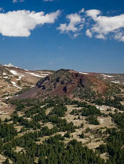 Ball Butte photographed by the National Park Service on August 12, 2008 | |
| Highest point | |
| Elevation | 8,091 |
| Coordinates | 44°03′57″N 121°40′35″W / 44.065916°N 121.676490°W / 44.065916; -121.676490 |
| Geography | |
 | |
| Location | Deschutes, Oregon, U.S. |
| Parent range | Cascade Range |
| Topo map | USGS Broken Top |
| Geology | |
| Volcanic arc | Cascade Volcanic Arc |
| Last eruption | Pleistocene |
Ball Butte is a volcanic mountain of the Cascades in Deschutes County, Oregon, United States.1 Its summit has an elevation of 8,091 feet and is located southeast of Broken Top.2 It is a popular back-country skiing area and is best accessed from the Dutchman Flat Sno-Park or the Upper Three Creeks Sno-Park.34
References
References
- Spear, B. A. (1996), "Petrology of the Ball Butte Volcano, central Oregon High Cascades: Evidence for mixing between basaltic andesite and rhyodacite (abs)", Geological Society of America Abstracts with Programs, v. 28.
- "Ball Butte". Medium.com. Retrieved January 2, 2018.
- "Backcountry Skiing & Snowboarding & Snowboarding in Bend, Oregon". VisitBend.com. Retrieved January 2, 2018.
- "Skiing and snowboarding". BendBulletin.com. Retrieved January 2, 2018.