Bíňa
Bény | |
|---|---|
 | |
 Flag | |
| Coordinates: 47°55′N 18°39′E / 47.92°N 18.65°E / 47.92; 18.65 | |
| Country | |
| Region | |
| District | Nové Zámky District |
| First mentioned | 1135 |
| Area | |
• Total | 23.50 km2 (9.07 sq mi) |
| Elevation | 130 m (430 ft) |
| Population | |
• Total | 1,404 |
| Time zone | UTC+1 (CET) |
| • Summer (DST) | UTC+2 (CEST) |
| Postal code | 943 563 |
| Area code | +421 363 |
| Vehicle registration plate (until 2022) | NZ |
| Website | www |
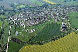
Bíňa (Hungarian: Bény) is a municipality and village in the Nové Zámky District in the Nitra Region of south-west Slovakia.
Geography
The municipality lies at an altitude of 130 metres (430 ft)3 and covers an area of 23.50 km2 (9.07 sq mi) (2025).4
History
In historical records the village was first mentioned in 1135 written as Byn. Earlier the Romans built a fortress here and in 173 emperor Marcus Aurelius wrote his famous diary in this region during the wars against quadi in the Marcomannic Wars. Later, after the foundation of the Árpád age Hungary, king Stephen I of Hungary gave the region to Bény, son of Hont, the count of the county Hont. During the time of early Christianity every 10 villages was ordered to build a church. Several rotunda have been built in this time, among others the rotunda of Bény, too. In 1217 the Premontre Abbey monastery was founded in Bíňa in the romanesque style. An earlier built rotunda stands before the two tower abbey church. The patrocinium of the rotunda is The 12 Apostles. Such patrocinium of a rotunda was at village Apostag at the Danube. After the Austro-Hungarian army disintegrated in November 1918, Czechoslovak troops occupied the area, later acknowledged internationally by the Treaty of Trianon. Between 1938 and 1945 Bíňa once more became part of Miklós Horthy's Hungary through the First Vienna Award. From 1945 until the Velvet Divorce, it was part of Czechoslovakia. Since then it has been part of Slovakia.
Population
| Year | 1995 | 2005 | 2015 | 2025 |
|---|---|---|---|---|
| Count | 1434 | 1476 | 1447 | 1404 |
| Difference | +2.92% | −1.96% | −2.97% |
| Year | 2024 | 2025 |
|---|---|---|
| Count | 1403 | 1404 |
| Difference | +0.07% |
It has a population of 1404 people (31 December 2025).6
Ethnicity
| Ethnicity | Number | Fraction |
|---|---|---|
| Hungarian | 1096 | 76.48% |
| Slovak | 244 | 17.02% |
| Not found out | 168 | 11.72% |
| Romani | 20 | 1.39% |
| Total | 1433 |
In year 2021 was 1433 people by ethnicity 1096 as Hungarian, 244 as Slovak, 168 as Not found out, 20 as Romani, 2 as Czech, 2 as German, 1 as Romanian and 1 as Other.
Note on population: The difference values of population numbers in the table "Population statistic" and in the sections "Ethnicity" & "Religion" is caused by the use of various statistical methods.
Religion
| Religion | Number | Fraction |
|---|---|---|
| Roman Catholic Church | 1026 | 71.6% |
| None | 198 | 13.82% |
| Not found out | 149 | 10.4% |
| Calvinist Church | 15 | 1.05% |
| Greek Catholic Church | 15 | 1.05% |
| Total | 1433 |
In year 2021 was 1433 people by religion 1026 from Roman Catholic Church, 198 from None, 149 from Not found out, 15 from Calvinist Church, 15 from Greek Catholic Church, 9 from Christian Congregations in Slovakia, 7 from Jehovah's Witnesses, 7 from Evangelical Church, 4 from Other, 1 from Old Catholic Church, 1 from Other and not ascertained christian church and 1 from Ad hoc movements.
Facilities
The village has a public library and football pitch.
Gallery


References
References
- "Hustota obyvateľstva - obce [om7014rr_obc=AREAS_SK, v_om7014rr_ukaz=Rozloha (Štvorcový meter)]". Statistical Office of the Slovak Republic. 2026-03-31. Retrieved 2026-03-31.
- "Počet obyvateľov podľa pohlavia - obce (ročne) [om7101rr_obce=AREAS_SK]". Statistical Office of the Slovak Republic. 2026-03-31. Retrieved 2026-03-31.
- "Základná charakteristika". www.statistics.sk (in Slovak). Statistical Office of the Slovak Republic. 2015-04-17. Retrieved 2022-03-31.
- "Hustota obyvateľstva - obce [om7014rr_obc=AREAS_SK, v_om7014rr_ukaz=Rozloha (Štvorcový meter)]". Statistical Office of the Slovak Republic. 2026-03-31. Retrieved 2026-03-31.
- "Počet obyvateľov podľa pohlavia - obce (ročne) [om7101rr_obce=AREAS_SK]". Statistical Office of the Slovak Republic. 2026-03-31. Retrieved 2026-03-31.
- "Počet obyvateľov podľa pohlavia - obce (ročne) [om7101rr_obce=AREAS_SK]". Statistical Office of the Slovak Republic. 2026-03-31. Retrieved 2026-03-31.
- "Population - Basic results". www.scitanie.sk. Statistical Office of the Slovak republic. Retrieved 2025-11-03.
- "Population - Basic results". www.scitanie.sk. Statistical Office of the Slovak republic. Retrieved 2025-11-03.
- "Population - Basic results". www.scitanie.sk. Statistical Office of the Slovak republic. Retrieved 2025-11-03.
- Gervers-Molnár Vera: A középkori Magyarország rotundái. (Romanesque Round Churches of Medieval Hungary) (Művészettörténeti Füzetek, 4.) Akadémiai Kiadó. Budapest, 1972.
Genealogical resources
The records for genealogical research are available at the state archive "Statny Archiv in Nitra, Slovakia"
- Roman Catholic church records (births/marriages/deaths): 1724-1895 (parish B)
- Reformated church records (births/marriages/deaths): 1784-1953 (parish B)
External links
External links
- Homepage of Bina (Bény)
- Information about Bina (Bény)
- Bina (Bény) in Slovakia Map
- Slovakiatourism.sk
- Basic information
- Slovenské hrady
- The rotunda and the monastery church at Bina (Bény)
- Bina (Bény)in the website homepage of istergranum.utikonyvem.hu
- Surnames of living people in Bina
- Bíňa – Nové Zámky okolie
- Bíňa, Vybrané štatistické dáta zo SODB 2011, Obyvateľstvo podľa národnosti