 | ||||
|---|---|---|---|---|
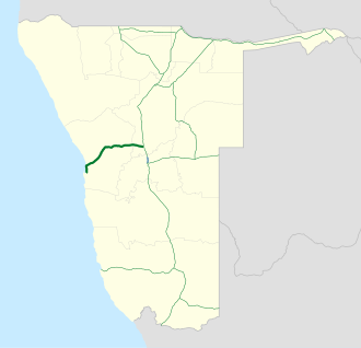 Map of the B2. | ||||
| Route information | ||||
| Maintained by Roads Authority Namibia | ||||
| Length | 320 km (200 mi) | |||
| Major junctions | ||||
| East end |   A1 / B1 near Okahandja A1 / B1 near Okahandja | |||
| West end |  C14 in Walvis Bay C14 in Walvis Bay | |||
| Location | ||||
| Country | Namibia | |||
| Towns | Okahandja, Karibib, Usakos, Arandis, Swakopmund, Walvis Bay | |||
| Highway system | ||||
| ||||

B2 is a major road in Namibia. The highway runs east–west between the major sea port of Walvis Bay and the nation's capital Windhoek.1
The B2's entire route forms the first section of both the Trans-Kalahari Corridor and the Walvis Bay-Ndola-Lubumbashi Development Road.

Route
B2 begins in Walvis Bay at a roundabout intersection with the C14 and heads north along the coast of the South Atlantic Ocean for about 35 kilometers to Swakopmund. The route then heads northeast & east through inland Namibia for 291 kilometers where it ends at an intersection with B1 near Okahandja, approximately 74 kilometres north of Windhoek. The route passes through the Namib-Naukluft National Park and the Namib Desert. Major towns along the route are Arandis, Usakos, and Karibib.
References
References
- "Along the B2 from Windhoek to the coast, Okahandja, Karibib and Usakos - The Bradt guide to Namibia". www.namibia-travel-guide.com. Retrieved 2026-05-17.
