Auroux | |
|---|---|
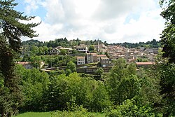 A general view of Auroux | |
 Coat of arms | |
 Location of Auroux | |
Auroux Auroux | |
| Coordinates: 44°45′13″N 3°43′41″E / 44.7536°N 3.7281°E / 44.7536; 3.7281 | |
| Country | France |
| Region | Occitania |
| Department | Lozère |
| Arrondissement | Mende |
| Canton | Langogne |
| Intercommunality | CC Haut Allier Margeride |
| Government | |
| • Mayor (2020–2026) | Anne-Marie Pijeau1 |
Area 1 | 35.09 km2 (13.55 sq mi) |
| Population (2023)2 | 364 |
| • Density | 10.4/km2 (26.9/sq mi) |
| Time zone | UTC+01:00 (CET) |
| • Summer (DST) | UTC+02:00 (CEST) |
| INSEE/Postal code | 48010 /48600 |
| Elevation | 909–1,271 m (2,982–4,170 ft) (avg. 950 m or 3,120 ft) |
| 1 French Land Register data, which excludes lakes, ponds, glaciers > 1 km2 (0.386 sq mi or 247 acres) and river estuaries. | |
Auroux (French pronunciation: [oʁu]; Occitan: Aurós) is a commune in the Lozère department in southern France.
Geography
The Chapeauroux forms part of the commune's southern border, flows north through the middle of the commune, then forms part of its northern border.
Population
| Year | Pop. | ±% p.a. |
|---|---|---|
| 1968 | 561 | — |
| 1975 | 504 | −1.52% |
| 1982 | 438 | −1.99% |
| 1990 | 395 | −1.28% |
| 1999 | 380 | −0.43% |
| 2007 | 440 | +1.85% |
| 2012 | 423 | −0.78% |
| 2017 | 385 | −1.86% |
| 2023 | 364 | −0.93% |
| Source: INSEE3 | ||
References
References
- "Répertoire national des élus: les maires" (in French). data.gouv.fr, Plateforme ouverte des données publiques françaises. 13 September 2022.
- "Populations de référence 2023" (in French). National Institute of Statistics and Economic Studies. 18 December 2025.
- Population municipale entre 1968 et 2023, INSEE