Aulas | |
|---|---|
 | |
 Coat of arms | |
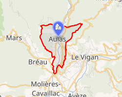 Location of Aulas | |
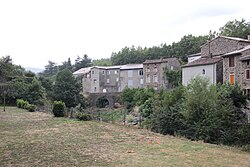
Aulas Aulas | |
| Coordinates: 44°00′04″N 3°35′14″E / 44.0011°N 3.5872°E / 44.0011; 3.5872 | |
| Country | France |
| Region | Occitania |
| Department | Gard |
| Arrondissement | Le Vigan |
| Canton | Le Vigan |
| Intercommunality | CC Pays Viganais |
| Government | |
| • Mayor (2020–2026) | Bruno Montet1 |
Area 1 | 2.91 km2 (1.12 sq mi) |
| Population (2023)2 | 456 |
| • Density | 157/km2 (406/sq mi) |
| Time zone | UTC+01:00 (CET) |
| • Summer (DST) | UTC+02:00 (CEST) |
| INSEE/Postal code | 30024 /30120 |
| Elevation | 264–642 m (866–2,106 ft) (avg. 316 m or 1,037 ft) |
| 1 French Land Register data, which excludes lakes, ponds, glaciers > 1 km2 (0.386 sq mi or 247 acres) and river estuaries. | |
Aulas (French pronunciation: [olas]; Occitan: Aulaç) is a commune in the Gard department in southern France.
Population
| Year | Pop. | ±% |
|---|---|---|
| 1962 | 232 | — |
| 1968 | 308 | +32.8% |
| 1975 | 296 | −3.9% |
| 1982 | 338 | +14.2% |
| 1990 | 386 | +14.2% |
| 1999 | 391 | +1.3% |
| 2008 | 440 | +12.5% |
| 2015 | 480 | +9.1% |
References
References
- "Répertoire national des élus: les maires". data.gouv.fr, Plateforme ouverte des données publiques françaises (in French). 9 August 2021.
- "Populations de référence 2023" (in French). National Institute of Statistics and Economic Studies. 18 December 2025.