| Aucanquilcha | |
|---|---|
| Aucaquilcha and Auncanquilcha1 | |
 View of Aucanquilcha volcano from the northwest | |
| Highest point | |
| Elevation | 6,176 m (20,262 ft)2 |
| Prominence | 2,145 m (7,037 ft)3 |
| Parent peak | Huascaran |
| Coordinates | 21°11′S 68°35′W / 21.183°S 68.583°W / -21.183; -68.5834 |
| Naming | |
| Etymology | Quechua: Auqa/aukka; "cruel"/"enemy", kichka/khiska; "spine"; "cruel spine"5 |
| Pronunciation | OW-kahn-KEEL-chuh |
| Geography | |
Aucanquilcha | |
| Parent range | Andes |
| Geology | |
| Rock age | Up to 11 Ma (Late Miocene) |
| Stratovolcano | |
| Rock type | Dacite |
| Volcanic zone | Central Volcanic Zone |
| Last eruption | 240,000 ± 50,000 years ago (Pleistocene)6 |
Aucanquilcha is a massive stratovolcano located in the Antofagasta Region of northern Chile, just west of the border with Bolivia and within the Alto Loa National Reserve. Part of the Central Volcanic Zone of the Andes, the stratovolcano has the form of a ridge with a maximum height of 6,176 metres (20,262 ft). The volcano is embedded in a larger cluster of volcanoes known as the Aucanquilcha cluster. This cluster of volcanoes was formed in stages over eleven million years of activity with varying magma output, including lava domes and lava flows. Aucanquilcha volcano proper is formed from four units that erupted between 1.04–0.23 million years ago. During the ice ages, both the principal Aucanquilcha complex and the other volcanoes of the cluster were subject to glaciation, resulting in the formation of moraines and cirques.
The cluster has generated lava ranging in composition from andesite to dacite, with the main volcano being exclusively of dacitic composition. Systematic variations in temperature, crystal and biotite content have been recorded during the evolution of the cluster.
At Aucanquilcha volcano there is some fumarolic activity, and sulfur deposits are found at the summit. Several sulfur mines lie in the complex. One mine at an altitude of 5,950 metres (19,520 ft) was opened in 1913 and remained in use from 1950 to 1992. It was the world's highest mine during that period. Originally, sulfur obtained at the mine was transported down with llamas. Subsequently, an aerial cableway was employed to transport the sulfur to the town of Amincha. To bring the sulfur down, a road network to the summit was constructed in 1972, although it is now impassable.
In 1986, four men were reported to be living at an altitude of 5,900 metres (19,400 ft), making them the highest permanent residents on Earth.
Geography and geomorphology

Aucanquilcha is a compound volcano7 that rises 1.4 kilometres (0.87 mi) above an andesite platform8 in the El Loa Province9 of Chile's Antofagasta Region.10 Roads and railways pass around the volcano,9 a branch line of the Antofagasta-Bolivia railway going to the Collahuasi mine11 passes by Aucanquilcha.12 A road with numerous switchbacks13 leads up to the Aucanquilcha mine; it was built in 1972 and is now impassable because of rock falls,14 and might have made the mine on Aucanquilcha the highest point on Earth accessible by road.12 The mountain was evaluated as a potential site for the European Southern Observatory.15
The main volcano is composed of an east-west 8-kilometre (5.0 mi) long chain of stratovolcanoes4 and has an estimated volume of 37 cubic kilometres (8.9 cu mi)a,8 making it one of the largest volcanoes of northern Chile.17 Four peaksb exceed altitudes of 6,000 metres (20,000 ft);19 the highest peak and summit of the Aucanquilcha volcano reaches 6,176 metres (20,262 ft)c17 and one can see the Salar de Uyuni and other Andean volcanoes from there.21 Lava flows, mostly from the summit areas, are dark to grey in colour and extend as far as 2–3 kilometres (1.2–1.9 mi) from their vents. It is likely that two small lava domes (Cerro Cumbre Negra and Summit 5867) on the northwest flank occupy flank vents.22 To the north lies the 3.3 mya old andesite Cerro Tres Monos ridge; to the west lies the east-west Cerro Polan and La Luna ridge.8
Aucanquilcha collapsed to the northwest,23 forming a 1 cubic kilometre (0.24 cu mi) debris avalance24 that descended 2,100 metres (6,900 ft) and ran for 17 kilometres (11 mi) with an azimuth of 311°, eventually covering an area of 59 square kilometres (23 sq mi)18 to form a tongue-shaped deposit.25 The flow was channeled between Miño Volcano and Cerro Cumbre Negra (an eroded lava massif) towards the dry Rio Loa valley, favouring the preservation of the slide deposit.26 The slide lacks the hummocky topography usually found on debris avalanches but has radial ridges and grooves and lateral levees;24 its upper sector is buried by more recent volcanic rocks and moraines.27 Another landslide occurred during the Redondo stage on the eastern side of the main volcano into the Salar de Carcote. It has the classic hummocky topography of landslides and covers a length of 17 kilometres (11 mi) and a surface area of 35 square kilometres (14 sq mi), roughly half of the surface area of the Mount St Helens avalanche of 1980 and one-third of the surface area of the Ollagüe avalanche. A volume of 0.35 cubic kilometres (0.084 cu mi) is assumed based on a probable thickness of 10 metres (33 ft).2829
The volcano is part of a quasi-circular cluster of about 19-20 volcanoes3019 between the Rio Loa and the Chile–Bolivia border,31 covering a surface area of 700 square kilometres (270 sq mi). salt flats and alluvial deposits surround it to the east, north and south. On its southern side lies the Cerro Chela volcano.3019 The cluster lies on a 70-kilometre (43 mi) thick crust,30 and arid conditions since the Miocene have preserved its structures.31 Its volcanoes are arranged in north-south and northwestern alignments, which may indicate a rupture of the crust above shallow magma reservoirs.32
There are anecdotal reports of crater lakes on the mountain,33 and a map shows a lake (El Toro) on its southern foot.34 Some of the source creeks and springs of the Rio Loa are on Aucanquilcha,3536 forming its headwaters when they converge in Lago Seco.3537 The Loa drains the western and northwestern sides of the volcano; the eastern side drains into the Salar de Ollagüe salt pan, the northeastern into the Salar de Laguani, and the southeastern into the Salar de Carcote. Most valleysd only intermittently transport water, if at all.40
Geology
Off the western coast of South America, the Nazca Plate subducts beneath the South America Plate at a rate of 7 centimetres per year (2.8 in/year).41 As it descends, it releases fluids into the mantle that induce its melting and the onset of volcanism at the surface.42 This volcanism of the Andean Volcanic Belt is distributed over four arcs,43 including the Northern Volcanic Zone (NVZ), the Central Volcanic Zone (CVZ) and Southern Volcanic Zone (SVZ),44 which are separated by gaps without volcanic activity.45 Aucanquilcha is part of the CVZ,8 which contains more than a thousand45 andesitic volcanoes, ignimbrites and compound volcanoes. During the past 28 million years, it has produced more than 3,000 cubic kilometres (720 cu mi) of eruption products;8 the average rate of 0.11 cubic kilometres per millennium (0.026 cubic miles per millennium) is one tenth of the global maximum rate of arc magma production.8 Rocks are typically silicic or have intermediate compositions between silicic and mafic.7 The arc has migrated eastward towards the high Andes from the Pacific Ocean coast since the Jurassic8 and has been producing ignimbrites and stratovolcanoes since the Miocene.19 The arc features an eastward offset at the latitude of Aucanquilcha.22 Lascar is the most active volcano of the CVZ, having erupted more than thirty times since 1800;43 other active volcanoes of the CVZ include Taapaca, Parinacota, Irruputuncu, Ollagüe, San Pedro, Socompa and Lastarria.46
The crust under the CVZ reaches high thicknesses exceeding 60–70 kilometres (37–43 mi), leading to widespread contamination of ascending magmas. The basement of the Central Andes consists of volcanic rocks and marine sediments from the Mesozoic, and volcanic and volcano-sedimentary rocks from the Cenozoic; they overlie metamorphic rocks and amphibolite in the lower crust.308 The offset in the volcanic arc coincides with a boundary between two distinct crustal domains to the north and south47 in the Arequipa-Antofalla terrane.48 A fracture in the crust under Aucanquilcha might be responsible both for its elongated shape and the dominance of effusive eruptions (as it would facilitate degassing).49 Seismic and electric tomography indicate the presence of a hot zone in the crust, which may be a developing batholith.19
The Aucanquilcha complex lies northwest of the Altiplano–Puna volcanic complex (APVC), a local large igneous province. The APVC is underpinned below at a depth of 20 kilometres (12 mi) by a slow seismic velocity zone that has been linked to the presence of 15–25% of partial melts in the zone. The Aucanquilcha complex is much smaller volumetrically than the APVC ignimbrites, but the duration of activity and the location indicate that Aucanquilcha is a subcomponent of the APVC complex.30 The volcano might be a surface manifestation of copper porphyry deposits and a batholith32-plutonic complex resembling the Tuolumne Intrusive Suite of the Sierra Nevada.50
Composition
The rocks from the main Aucanquilcha volcano are uniformly dacitic and show little evidence of temporal variation in their composition,51 while the Aucanquilcha complex produced both andesite and dacite. Andesites appear as lava flows while dacites form lava domes and dome complexes.4 The rocks define a calc-alkaline suite52 rich in potassium (content ranges from 1.5 to 4%53), typical for Central Andean volcanoes and subduction zone volcanoes in general.318 Plagioclase is the dominant component of the magma. Clinopyroxene+orthopyroxene+amphibole (hornblende and pargasite) or amphibole+biotite+minor amounts of pyroxene are subordinate components. Apatite, ilmenite, magnetite and zircon can also be found.5154 Rocks have a porphyritic texture and the more recent (last 1 million years) rocks contain inclusions of mafic rocks.55 Basaltic andesites typically contain less than 10% crystals while dacites generally have more than 20% crystals. The Alconcha group lavas form two distinct families: Early lavas are crystal-poor and lack biotite, later rocks contain biotite and more crystals.56 There is evidence of magma mixing and mingling,5130 and of multiple generations of crystals being sampled from the magma reservoir57 especially during inactive periods.58 The magmas form at 5–20 kilometres (3.1–12.4 mi) depth.59
Various parts of the main volcano have been subjected to hydrothermal alteration28 and alteration by fumarolic activity, especially the central parts of the complex4 and the Azufrera stage edifice.28 The central part of the complex is heavily altered by fumarole activity.4 Hydrothermal alteration may be driven by the formation of a deep magma reservoir and resulting hydrothermal circulation in overlying rocks.60 The summit area and the area between the Azufrera and Angulo complex feature sulfur rich talus deposits,28 including pyrite61 and hypogene-derived copper sulfides such as covellite62 that were emplaced before the sulfur deposits.63 The copper sulfides found in the area appear to have formed through postvolcanic epithermal mineralization above deep porphyry copper mineralization.64 The sulfur itself formed at temperatures of 450 °C (842 °F)65 in a now extinct fumarole,66 although Ahlfeld 1947 reported ongoing formation of sulfur crystals in a cave on the summit.67
Magma output and evolution
The Aucanquilcha complex had a fairly stable magma output between 12 and 6 million years ago, followed by an acceleration that resulted in a peak between 4 and 1 million years ago (with a possible hiatus between 2 and 1 million years ago).68 The long-term magma output of Aucanquilcha is comparable to the magma output of other long-term active volcanoes in the central Andes such as Ollagüe and Llullaillaco. In all such cases, an early peak in magma output is followed by later lower-volume activity (0.1 to 0.2 cubic kilometres per millennium (0.024 to 0.048 cubic miles per millennium), followed by 0.01 to 0.02 cubic kilometres per millennium (0.0024 to 0.0048 cubic miles per millennium)). Unzen in Japan and Mount Duff and Lassen Peak in California have similar eruption histories.69 Such decreases may occur because of the lithostatic load imposed by the edifices on the magma chambers and the increased travel distance of the magma through the edifice.70 The comparatively low output of Aucanquilcha might reflect the fact that it is located at the edge of the Altiplano-Puna volcanic complex,71 and might explain why no major caldera-forming eruption ever took place.72
The repeated formation of magma chambers heated the crust under the volcano, warming the magmatic system.73 This crustal feedback and increased deep crustal influx of mantle-derived basalts drove increased magma production,32 and ephemeral shallow magma chambers formed which were supplied from the deeper reservoir.74 Eruption rates and hydrothermal activity increased,75 and crystal populations in the magmatic system shifted.76 4 million years ago the magmatic system became centralized77 and stable, allowing the continuous production of dacitic magmas.78 Dacite built up under the volcano and formed a barrier to the ascent of denser magmas,71 so that andesite was spatially segregated with the peripheral Miño Volcano while the more central volcanoes erupted dacites.79 The Aucanquilcha volcanic complex has been interpreted as the surface component of a developing pluton.55
Crustal rocks were absorbed in the magma, especially the more evolved (dacitic) ones80 and during declining stages.81 Magma and included crystals being drawn from depths of 3 to 23 kilometres (1.9 to 14.3 mi) during the main Aucanquilcha stage of volcanism,3082 with evidence of stronger crustal contributions or of a change of their composition.80 Based on geothermometric data, the highest temperatures occurred during phases of high activity and lower temperatures are associated with low output periods.73
Eruptive history
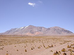
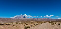
Volcanic activity of the Aucanquilcha cluster commenced 11 million years ago,7 increasing 6-5 million years ago at the same time as magmas becoming more uniform in composition and strong hydrothermal alteration commenced. The Aucanquilcha cluster generated about 340 ± 20 cubic kilometres (81.6 ± 4.8 cu mi) of volcanic rock,30 with each centre being active for a few hundred thousand years.71 Over time, centres became less distributed and their magmas more uniform.83 Activity waned 2-1 million years ago,3082 the Aucanquilcha volcano proper may be a waning stage of the overall cluster.32 Both the timing80 and the duration of volcanic activity of the Aucanquilcha cluster are comparable to that of the Altiplano–Puna volcanic complex.84
Aucanquilcha itself began erupting about 1 million years ago, producing mostly lava flows with little variation in eruption style85 and with a prolonged decline after an initial phase of high output.86 Eruptions occurred every 50,000-100,000 years, with breaks reaching 250,000 years.87The age of the lava flows ranges from heavily glaciated andesite flows overlying less-eroded ones to possibly postglacial lava flows that may be tens of thousands of years old.4 The site of volcanic activity migrated over time.88
Stages
Both the Aucanquilcha cluster and Aucanquilcha proper formed in four stages each:
- The Alconcha group, with seven volcanoes, is constructed from andesite and dacite and formed 11–8 mya. It is constructed from two northern composite cones, Alconcha and Volcan Tuco (also known as Cerro Garage, dated 10.96–10.51 mya), and five lava domes on the northeastern side of the cluster. Alconcha has a large breach on the southern side of its crater that is likely the product of a flank collapse79 but the avalanche deposit may be buried beneath younger material. Lavas within the breach are dated 10.78–10.43 mya. The centres of Volcan Tuco and Alconcha are heavily eroded, and Alconcha's lavas and scoria lie on top of Tuco. The Ujina ignimbrite was erupted 9.4 mya from an unknown vent and has a volume of 2 cubic kilometres (0.48 cu mi) of dacite. While the vent location is unknown, the composition of the ignimbrite, and its dating and distribution, indicate an association with this group. The domes are poorly researched, with the Coscalito dome dated 8.9–8.7 mya and Cerro Amincha 8.01.89 The total volume of this group is 46 cubic kilometres (11 cu mi), indicating a flux rate of 0.013 cubic kilometres per millennium (0.0031 cubic miles per millennium).90
- The Gordo group, which erupted 6–4 mya following a probable 2-million-year hiatus,79 is located in the southern and western parts of the cluster. Cerro Gordo itself (5.49 mya) has a crater that is breached westwards, exposing about twelve radial dykes but with no trace of a debris avalanche. One of the larger centres of the cluster, Gordo is associated with a lava field on its western side that is dated 4.9 mya. Cerro Puquíos and Cerro Negro (5.81–5.28 mya) lie on the southern side of the cluster, and glacial cirques cutting their northeastern flanks reveal layers of scoria and lavas. Puquíos has an amphitheatre structure on its western side. Paco Paco (4.41–4.27 mya) is located north of most Gordo group volcanoes. It forms a 4 kilometres (2.5 mi) wide stratocone with a lava-filled crater, and layers of scoria and agglutinated lavas dip from it. Volcan Pabellón (4.14–4.12 mya) sits southwest of the Puquíos-Negro ridge. The Las Bolitas lava field (5.23–5.13 mya) is associated with the Gordo group but the vent locations are unknown.68 The total volume of this group is 55 cubic kilometres (13 cu mi), indicating a flux rate of 0.027 cubic kilometres per millennium (0.0065 cubic miles per millennium).90
- The 3.6–2.3 mya Polan group,68 with ten dispersed volcanoes including Miño Volcano, is the largest group in the cluster and includes Tres Monos, La Luna, Cerro Polan, Chaihuiri, Miño Volcano and the lavas of the Aucanquilcha platform. Cerro Polan's (3.5–3 mya) eastern side is deeply dissected, and the exposed materials are heavily altered in the deeper sections. Lava fields to Polan's west and southwest (2.6 mya on one western field) are associated with it. La Luna (2.97–2.57) lies just east of Polan; these two volcanoes were probably one volcano in the past. La Luna has a lava dome surrounded by a glaciated but unaltered lava table. Cerro Tres Monos (3.4–2.78 mya) forms a northbound 14-kilometre (8.7 mi) long ridge with at least six vents. Hydrothermal alteration has affected some lavas and pyroclastics from Tres Monos, and the western side has lateral and terminal moraines. The Aucanquilcha platform (3.6–2.7 mya) sits underneath the main Aucanquilcha volcano, and its lava mostly flowed north. Its southern side is a 4,500-metre (14,800 ft) table with one hill, Cerro Campana, dated to 3.3 mya. The platform presumably forms one third of the total volume of the Aucanquilcha cluster91 and may have originated from a part of the ridge of the La Luna-Polan trend, now buried beneath Aucanquilcha. Chaihuiri (2.39 mya) is a lava dome with moraines and two short lava flows; it is the youngest Polan group volcano.29 The total volume of this group is 154 cubic kilometres (37 cu mi), indicating a flux rate of 0.077 cubic kilometres per millennium (0.018 cubic miles per millennium).90
- The main Aucanquilcha volcano is the youngest volcano in the cluster7 and formed in four stages:
- Between 1.04–0.92 mya the bulk of the volcano formed in the Azufrera stage.22 One lava flow toward the southwest is unusually long at 6 kilometres (3.7 mi). A vent at 6,116 metres (20,066 ft) altitude fed most of this edifice; a second vent on the northern flank at the 5,887 metres (19,314 ft) summit generated three lava flows, two shorter ones and a long one to the northwest. The Azufrera stage lavas are blocky dacites with large clasts and flow fronts up to 20 metres (66 ft) high. These flows are moderately altered and have oxidation rinds. There is little evidence of explosive activity, but it may have been obscured by glacial erosion.28 The total volume is 21.1 cubic kilometres (5.1 cu mi), indicating a flux rate of 0.16 cubic kilometres per millennium (0.038 cubic miles per millennium).51 This volcano was probably an isolated cone, but the existence of a previous stage cannot be excluded.92
- The second stage, named Rodado, lasted from 0.95 to 0.85 mya. It formed on the eastern slopes of the Azufrera volcano, with one vent at the 6,073 metres (19,925 ft) summit. Rodado stage lavas are blocky and platy and usually thicker than Azufrera stage lavas. Some of the summit vent lavas are among the most vesicular of this stage. They are also less weathered (oxidation rinds are c. 1 centimetre (0.39 in) thick) and less subject to solfataric alteration. The Cerro Chinchillas lavas are the oldest of this stage; erupted from an unknown vent, they lack amphiboles.28 The total volume is 9.1 cubic kilometres (2.2 cu mi), indicating a flux rate of 0.09 cubic kilometres per millennium (0.022 cubic miles per millennium).51 A flank collapse, possibly triggered by a large earthquake, occurred during this stage.92
- The third stage is the Cumbre Negra stage, named after the westernmost summit and principal vent of this stage, Cerro Cumbre Negra (5,670 metres (18,600 ft)). The time course of its activity is less defined than the previous two stages; it may have occurred between 1–0.47 mya, but most likely 0.6–0.5 mya based on potassium–argon dating. Four lava flows derived from the main vent, all less than one kilometre long and 40–60 metres (130–200 ft) thicker than previous stages. They all have hydration rinds but no native sulfur deposits. This stage generated Aucanquilcha's only pyroclastic flowe during a lava dome collapse as occurred on Merapi in Indonesia.28 The total volume of this stage is 0.7 cubic kilometres (0.17 cu mi), indicating a flux rate of 0.005 cubic kilometres per millennium (0.0012 cubic miles per millennium).51
- The youngest stage, known as Angulo, lasted from 0.66 to 0.24 mya. It was centered between the Azufrera and Rodado stage edifices 0.35–0.23 mya.28 Most lava flows from this stage originate on a 1-kilometre (0.62 mi) long ridge that includes Aucanquilcha's highest summit. One crater on the northeast side of the ridge fed lavas to the north. Other than that, most flows extend southwards 4 to 9 kilometres (2.5 to 5.6 mi) from the vent, and with the exception of a due south flow 50 metres (160 ft) thick they are thin, with thicknesses of 15–20 metres (49–66 ft). One of the oldest flows has been compared in length to the 50% longer Chao Dacite flow but is much thinner. The flows from this stage are weakly weathered and partially overlie glacial deposits. The total volume is 5.8 cubic kilometres (1.4 cu mi), indicating a flux rate of 0.015 cubic kilometres per millennium (0.0036 cubic miles per millennium).51
Last activity, fumaroles and hazards
The last dated eruption occurred 450,000±70,000 years ago.93 Some scoria cones of basaltic composition, including Poruñita and Luna de Tierra, formed between Aucanquilcha and Ollagüe after Aucanquilcha's last activity.83 There is no clear evidence of Holocene activity,94 except possibly for lava flows overlying moraines,9217 and no known historical eruptions95 or ongoing ground deformation.96 There are active fumaroles17 or hot ground,61 most conspicuous in the trenches dug during sulfur mining operations.87f The emitted gases have temperatures of 60–85 °C (140–185 °F);99 alternatively they have been described as "low temperature".98
The Chilean geology agency SERNAGEOMIN in 2019 considered Aucanquilcha a low hazard volcano, ranking it 70th out of 92 Chilean volcanoes100 and 73th out of 91 in 2014.101 As of 2021 Aucanquilcha was not monitored.102 Lava flow emissions and minor explosive activity, confined to the edifice of the volcano, are the most important risks from renewed activity,87 a hazard map has been published.34 There are signs that warn of volcanic danger in the area.103
Climate and vegetation
Temperatures at the summit are usually below freezing,104g but insolation is among the highest on Earth's surface15 and can cause sunburns.106 Mean annual precipitation at Aucanquilcha is unknown, but at Ollagüe in 1963 it did not exceed 100 millimetres (3.9 in) per year107 and occurs mostly during summer as the so-called Bolivian winter.108 Aridity has prevailed here since the Miocene31 but with short-term fluctuations, a more humid period between 14,000-9,500 years ago and a drier period between 9,000 and 4,000 years ago for example.45 The summit region is windy109 and can experience snowstorms,110 and there is a seasonal snow cover that can reach a substantial thickness.111
Three distinct vegetation belts occur in the region. While the aridity prevents plant growth below 3,100 metres (10,200 ft) altitude, a sparse cover of Acantholippia punensis exists above this altitude. Between 3,750–3,300 metres (12,300–10,830 ft) vegetation is denser, featuring Baccharis boliviensi and Fabiana densa. A more diverse plant community is found between 4,100 metres (13,500 ft) and 3,750 metres (12,300 ft), consisting of bushes and grasses. Species there include Azorella compacta, Festuca chrysophylla, Pycnophyllum and Stipa venusta. The occurrence of Polylepis has been reported. The exact vegetation structure depends on the availability of water.112108 Vegetation cover ends at about 4,900 metres (16,100 ft) altitude.113 Mice have been found around 4,500 metres (14,800 ft) altitude;114 regional mice populations are known to reach extreme altitudes.115
Glaciation
There is some snow and ice on the mountains,116 as well as rock glaciers between 5,200–5,500 metres (17,100–18,000 ft)117 and permafrost down to 4,385 metres (14,386 ft) altitude,118 but with the exception of one 1999 report119 sources agree that there are no active glaciers on Aucanquilcha120121 as the climate is too dry for glacier development despite the low temperature.122
During glacials a 45 square kilometres (17 sq mi) ice cap covered the volcano,116 leaving cirques,123 glacial striations19 and extensive moraines17 on both on the main volcanoh and its subsidiaries.37 The exact altitude of the ice edge ranged between 4,500–5,200 metres (14,800–17,100 ft)i,19124 with lower altitudes reached on the eastern and southeastern side.125 At least two distinct glacier stages took place.37 The development of glaciers in the region was probably a consequence of a wetter climate.126
Human activity and mining
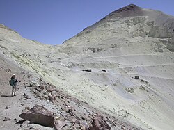

Aucanquilcha features a mine at 5,950 metres (19,520 ft) altitude,127 famous for being the highest mine in the world.128 It produced sulfur ore with a grade of 30%129 emplaced by fumaroles130 in the area of hydrothermally altered rocks around the summit.95 The mine was opened by Julian B. Carrasco in 1913, who subsequently established the Compañía Minera y Azufrera Carrasco S.A in 1933,131 first at Ollagüe and after 1950 in Amincha.132 In 1942, the mine produced about 180 tons of ore per day,133 in 1953 annual production was 12,000 tons.134 The sulfur was transported down first with llamas, later by trucks135 and eventually through an aerial cableway system from Quilca/El Ángulo to Amincha station136137 (3,900 metres (12,800 ft))14 where the sulfur was refined.138 The sulfur was then transported to Chuquicamata to be converted into sulfuric acid139 or to Antofagasta to be shipped;137 the Antofagasta-Bolivia railway was essential for the sulfur mining in the Ollagüe area.140 In 1977 other sulfur mines were present to the west between Cerro Polan and Cerro Gordo and south of the main Aucanquilcha massif,40 and another camp (Polan) is marked on modern maps west-southwest of Aucanquilcha.34 Neighbouring volcanoes were also mined.11
In 1935, mining took place throughout the year141 but typical workhours were only about 8 hours per day owing to the conditions.142 Owing to the extreme conditions, sulfur from the mines in the Ollagüe area was only rarely competitive on global markets.140 After an initial crisis in the 1950s,143 sulfur mining began to decline in the Ollagüe region during the 1970s;144 during the 1980s145–1990s the worker camps were abandoned.132 Amincha was closed in 1992145 or 1993,146 and the last reported mining activity on the mountain was in 1993147 or 1994.8 The mines and adjacent infrastructure were investigated beginning in 2015 as part of the Alto Cielo Archaeological Project148 and there has been research on the living conditions149 and ethnic relations between Bolivian and Chilean workers in the region.150
There are still ruins of the cableway,151 a relic network of roads leading up to 5,900 metres (19,400 ft)8 as well as ruins of the Amincha and El Ángulo stations.152 Apart from mining activity, an Inca mountain sanctuary with offerings of llamas has been reported to exist on Aucanquilcha.153 Such Inca findings are common on mountaintops of the region.111 Other archaeological sites are found around the volcano,154 including the Inca road Qhapaq Ñan,155 and there might have been copper mining at Miño.156
The inhabitants of Ollagüe viewed Aucanquilcha as the devil's mountain157 and nicknamed it "El Rebelde".128 Its masculine nature (reflecting the hard work of mining) was contrasted to the female, more ambiguous, interpretation of Ollagüe volcano.158 Anecdotal reports indicate that mine workers presented offerings to the mountain to secure a high mine yield.159 According to a local folktale, when the Spaniards attempted to rename the mountain to San José, it resisted as it had been named by the goddess Pachamama and occasionally throws sulfur and kills miners on the mountain.160
Altitude and habitation
The sulfur mine is notable for being the highest mine in the world at 5,950 metres (19,520 ft)161 and just below it95 is (formerly) the highest permanently inhabited place on Earth23 in the form of a galvanized iron hut.162 In 1986, several caretakers lived there, including Justo Copa who had been living there for two years;163162 they were the highestj human inhabitants on Earth.165
With increasing altitude, atmospheric pressure decreases and with it the availability of oxygen for breathing, eventually leading to altitude sickness.166 Aucanquilcha has been used for studies on the effects of high altitude on human behaviour167 and medical parameters. They168 indicated that the Aymara miners are fully acclimatized to the altitude, with less hyperventilation and higher hemoglobin than acclimatized people from lower areas,169 and are more tolerant of the high altitude than the researchers who studied them in 1942,170 although some European workers managed to tolerate the environment too.111 Their families are born and raised at lower altitudesk,165 although they could handle the high altitude conditions as well.171 Only a small fraction of the mineworkers could live on Aucanquilcha for longer timespans,172 leading to a frequent turnover in personnel173 and high sickness and mortality.174
Notes
Notes
- There are smaller estimates16
- The maximum slope of the summit area is 25°.18
- Some sources have different altitudes, e.g 6,190 metres (20,310 ft)20
- The Rio Blanco,10 Rio Casicsa,34 Rio Chela38 and Quebrada de Chaigüire valleys originate at the foot of Aucanquilcha.39
- During the Cumbre Negra stage, a pyroclastic flow occurred on the northwestern side of the volcano. It covered 34 square kilometres (13 sq mi) on a run of 10 square kilometres (3.9 sq mi) and now has a volume of 0.3 cubic kilometres (0.072 cu mi). It was at first identified as a debris avalanche, but the lack of hummocky topography and the presence of large juvenile blocks identify it as a pyroclastic flow.28 One block in the flow and the lava dome from which the flow originated have been dated at 0.6 mya.29
- Sources disagree on whether their thermal anomalies are visible from space97 or not.98
- In 1963 the temperature at the summit of Aucanquilcha was about −8 °C (18 °F).105
- The western Azufrera edifice was heavily glaciated in the past. At least three moraine stages have been mapped on that edifice, and on its southern side is found a modest cirque with glacially polished lavas on the floor. The Rodado stage edifice has several moraine stages on its southern slopes. Another small cirque with a moraine has been found in the northeastern side of the Cerro Cumbre Negra summit next to an Azufrera stage lava flow.28 A small moraine lies on the south side of the Angulo edifice; some lavas from that edifice overlie glacial deposits.51
- Identical to the altitude of the cirques.123
- An expedition in 1935, part of the International High Altitude Expedition,164 found that 150 miners lived at an altitude of 5,300 metres (17,500 ft) in Quilcha141 and reached the higher mine on foot. The expedition found that an even higher abandoned village at 5,639 metres (18,501 ft) existed, but miners refused to live there. The conclusion taken from the expedition was that 5,334 metres (17,500 ft) was the highest habitable altitude164 but later investigations recognized that the caretakers lived at higher altitudes.162
- The highest known town with families is La Rinconada in Peru.162
References
References
- Risopatrón 1924, p. 54.
- Kull & Grosjean 2000, p. 627.
- Andes Specialists 2020.
- Wörner et al. 1994, p. 83.
- Andes Handbook 2025.
- Klemetti & Grunder 2007, p. 637.
- Klemetti & Grunder 2007, p. 633.
- Klemetti & Grunder 2007, p. 634.
- Grunder et al. 2008, p. 418.
- Berenguer et al. 2005, p. 11.
- Rivera et al. 2025, p. 3.
- West 2000, p. 150.
- Rivera 2025, p. 128.
- West 2002, p. 404.
- Woltjer 1991, p. 7.
- Aravena, Villalón & Sánchez 2015, p. 5.
- GVP 2026, General Information.
- Francis & Wells 1988, p. 260.
- Grunder et al. 2008, p. 417.
- RHODES & WALKER 1974, p. 451.
- McIntyre 1987, p. 456.
- Klemetti & Grunder 2007, p. 635.
- Francis & Wells 1988, p. 267.
- Shea & van Wyk de Vries 2008, p. 664.
- Shea & van Wyk de Vries 2008, p. 663.
- Francis & Wells 1988, pp. 267, 269.
- Francis & Wells 1988, p. 269.
- Klemetti & Grunder 2007, p. 638.
- Grunder et al. 2008, p. 423.
- Walker, Grunder & Wooden 2010, p. 1007.
- Grunder et al. 2008, p. 416.
- Grunder et al. 2008, p. 432.
- Yoshikawa et al. 2025, p. 18.
- Amigo, Bertin & Orozco 2012, p. 47.
- Subercaseaux 2005, p. 68.
- Correa 2021, p. 188.
- Jenny & Kammer 1996, p. 49.
- Niemeyer 1980, p. 125.
- Villagrán, Romo & Castro 2003, p. 78.
- Defense Mapping Agency Hydrographic/Topographic Center, Washington DC 1977.
- Wörner, Mamani & Blum-Oeste 2018, p. 238.
- Wörner, Mamani & Blum-Oeste 2018, p. 237.
- Amigo, Bertin & Orozco 2012, p. 5.
- Klemetti & Grunder 2007, pp. 634–635.
- Amigo, Bertin & Orozco 2012, p. 6.
- Amigo, Bertin & Orozco 2012, p. 7.
- Grunder et al. 2008, pp. 416–417.
- Mamani, Worner & Sempere 2010, pp. 168–169.
- Klemetti & Grunder 2007, p. 647.
- Grunder, Miller & Walker Jr 2014, p. 374.
- Klemetti & Grunder 2007, p. 639.
- Klemetti & Grunder 2007, p. 641.
- Gunn 1974, p. 3.
- Walker, Grunder & Wooden 2010, p. 10.
- Wörner, Mamani & Blum-Oeste 2018, p. 241.
- Walker et al. 2012, p. 664.
- Walker et al. 2012, p. 677.
- Walker, Grunder & Wooden 2010, p. 1010.
- Wörner, Mamani & Blum-Oeste 2018, p. 242.
- Grunder et al. 2008, pp. 429, 432.
- Sillitoe 1973, p. 811.
- Clark 1970, p. 914.
- Ericksen 1976, p. 20.
- Ferraris & Vila 1990, p. 692.
- Rouwet et al. 2015, p. 162.
- Rouwet et al. 2015, p. 159.
- Ahlfeld 1947, pp. 113–114.
- Grunder et al. 2008, p. 421.
- Klemetti & Grunder 2007, p. 645.
- Klemetti & Grunder 2007, p. 646.
- Grunder et al. 2008, p. 427.
- de Silva 2008, p. 672.
- Walker et al. 2012, p. 678.
- Klemetti & Grunder 2003, p. 324.
- Grunder et al. 2008, pp. 432–433.
- Walker, Grunder & Wooden 2010, p. 1009.
- Buckley & Michelfelder 2021.
- Muir et al. 2015, pp. 75–76.
- Grunder et al. 2008, p. 419.
- Walker Jr, Grunder & Klemetti 2009, p. 291.
- Walker & Grunder 2010.
- Walker et al. 2012, p. 680.
- Walker et al. 2012, p. 665.
- Salisbury et al. 2010, p. 19.
- Klemetti & Grunder 2007, p. 643.
- Klemetti & Grunder 2007, p. 648.
- Amigo, Bertin & Orozco 2012, p. 14.
- De Silva & Francis 1991, p. 184.
- Grunder et al. 2008, pp. 419, 421.
- Grunder et al. 2008, p. 429.
- Grunder et al. 2008, p. 422.
- Klemetti & Grunder 2007, p. 644.
- Amigo, Bertin & Orozco 2012, p. 39.
- Lara et al. 2021, p. 620.
- GVP 2026, Photo Gallery.
- Pritchard & Simons 2004, p. 10.
- Jay et al. 2013.
- Rothery, Francis & Wood 1988, p. 7996.
- Ahlfeld 1947, p. 114.
- SERNAGEOMIN 2020.
- SERNAGEOMIN 2014.
- Amigo 2021, p. 2.
- Rivera 2025, p. 133.
- Butler 1936, pp. 2–3.
- Kessler 1963, p. 168.
- Butler 1936, p. 3.
- Kessler 1963, p. 169.
- Beaucournu et al. 2012, p. 214.
- Keys 1936, p. 304.
- Rivera 2025, p. 127.
- McIntyre 1993.
- Berenguer et al. 2005, p. 13.
- Storz et al. 2024, Table S2.
- Storz et al. 2024, Table S1.
- Storz et al. 2024, p. 726.
- De Silva & Francis 1991, p. 64.
- Schröder 1999, p. 131.
- Yoshikawa et al. 2025, p. 5.
- Schröder 1999, p. 129.
- Hastenrath 1971, p. 257.
- Barcaza et al. 2017, p. 168.
- Ammann et al. 2001, p. 321.
- Hastenrath 1971, p. 260.
- Schröder 1999, p. 128.
- Ammann et al. 2001, p. 317.
- Ammann et al. 2001, p. 322.
- Wu 2001, p. 495.
- Rivera 2018, p. 89.
- Erickson 2009, p. 243.
- Zeil 1964, p. 752.
- González 2010, p. 102.
- Rivera et al. 2021, p. 28.
- Ballester & Richard 2022, p. 41.
- Rivera, Galaz-Mandakovic & Vilches 2025, p. 87.
- Rivera 2020, p. 54.
- Keys 1936, p. 291.
- Rivera 2020, p. 56.
- Rivera 2020, pp. 51, 54.
- Wilson 2009, p. 198.
- Weischet 1966, p. 69.
- Keys 1936, p. 302.
- Keys 1936, p. 303.
- Rivera, Galaz-Mandakovic & Vilches 2025, p. 83.
- Rivera 2025, p. 126.
- Galaz-Mandakovic & Rivera 2023, p. 241.
- Rivera 2023, p. 17.
- Casey & Mehan 2023, p. 1.
- Rivera 2023, p. 16.
- Galaz-Mandakovic & Rivera 2023, p. 252.
- Galaz-Mandakovic & Rivera 2023, p. 253.
- Rivera 2020, pp. 58–59.
- Rivera 2020, pp. 57, 59.
- Bello 2025, p. 41.
- Berenguer et al. 2005, p. 9.
- Berenguer et al. 2005, p. 36.
- Berenguer et al. 2005, p. 22.
- Rivera 2022, p. 178.
- Rivera 2022, p. 179.
- Rivera 2022, pp. 178–179.
- Rivera 2022, p. 173.
- West 2002, p. 403.
- West 2009, p. 203.
- Gonzalez & Fedde 2012, p. 10.
- West 2002, p. 402.
- Nilsson 2010, p. 268.
- Keys 1936, p. 289.
- McFarland 1937, p. 137.
- Santolaya et al. 1997, p. 381.
- Santolaya et al. 1989, p. 253.
- JAMA 1942, p. 831.
- Parkes 1971, p. 15.
- Gonzalez & Fedde 2012, p. 11.
- Butler 1936, pp. 1–2.
- Laaidi & Besancenot 2002, p. 9.
Sources
- Ahlfeld, F. (1947). "Dos estudios sobre depósitos de azufre". Revista de la Asociación Geológica Argentina (in Spanish). 2 (2): 113–115. ISSN 1851-8249.
- Amigo, Álvaro R.; Bertin, Daniel U.; Orozco, Gabriel L. (2012). Peligros volcánicos de la Zona Norte de Chile (PDF) (Report). Carta geológica de Chile: Serie Geología Ambiental (in Spanish). Vol. 17. SERVICIO NACIONAL DE GEOLOGÍA Y MINERÍA. p. 14. ISSN 0717-7305. Archived from the original (PDF) on 29 June 2021. Retrieved 20 August 2021.
- Amigo, Alvaro (1 November 2021). "Volcano monitoring and hazard assessments in Chile". Volcanica. 4 (S1): 1–20. doi:10.30909/vol.04.S1.0120. ISSN 2610-3540.
- Ammann, Caspar; Jenny, Bettina; Kammer, Klaus; Messerli, Bruno (August 2001). "Late Quaternary Glacier response to humidity changes in the arid Andes of Chile (18–29°S)". Palaeogeography, Palaeoclimatology, Palaeoecology. 172 (3–4): 313–326. doi:10.1016/S0031-0182(01)00306-6.
- "Volcán Aucanquilcha". www.andeshandbook.org. Archived from the original on 2024-12-08. Retrieved 2025-01-18.
- "Aucanquilcha". Andes Specialists. Archived from the original on 18 August 2021. Retrieved 12 April 2020.
- Aravena, D.; Villalón, I.; Sánchez, P. (2015). Igneous Related Geothermal Resource in the Chilean Andes. World Geothermal Congress 2015. Melbourne.
- Ballester, Benjamín; Richard, Nicolas, eds. (2022). Cargar y descargar en el desierto de Atacama (in Spanish). Éditions de l’IHEAL. doi:10.4000/BOOKS.IHEAL.9706. ISBN 978-2-37154-166-5.
- Barcaza, Gonzalo; Nussbaumer, Samuel U.; Tapia, Guillermo; Valdés, Javier; García, Juan-Luis; Videla, Yohan; Albornoz, Amapola; Arias, Víctor (July 2017). "Glacier inventory and recent glacier variations in the Andes of Chile, South America". Annals of Glaciology. 58 (75pt2): 166–180. Bibcode:2017AnGla..58..166B. doi:10.1017/aog.2017.28.
- Beaucournu, J.-C.; Mergey, T.; Muñoz-Leal, S.; González-Acuña, D. (1 August 2012). "Description de Tunga bonneti n. sp. du Chili (Siphonaptera : Tungidae) et notes sur sa spécificité, sa chorologie, son dermecos et sa phénologie". Parasite (in French). 19 (3): 207–216. doi:10.1051/parasite/2012193207. ISSN 1252-607X.
- Bello, Christian Vitry Di (28 October 2025). "Donde habitan los dioses: una aproximación a los apus más altos del Tawantinsuyu". Boletín de Arqueología PUCP (in Spanish) (37): 7. doi:10.18800/boletindearqueologiapucp/202502.002. hdl:20.500.14657/205106. ISSN 2304-4292.
- Berenguer, José R; Cáceres, Iván R; Sanhueza, Cecilia T; Hernández, Pedro V (2005). "El Qhapaqñan en el Alto Loa, norte de Chile: Un estudio micro y macromorfológico". Estudios atacameños (29): 7–39. doi:10.4067/S0718-10432005000100002. ISSN 0718-1043.
- Buckley, Kasey; Michelfelder, Gary (December 2021). Aucanquilcha Volcanic Cluster Magma Plumbing System Architecture and Magma Storage Timescales for the Gordo and Polan Stage Lavas. AGU Fall Meeting 2021. New Orleans, Louisiana. Bibcode:2021AGUFM.V35B0133B. V35B-0133.
- Butler, C. P. (1936). "Observing the sun at 19,300 feet altitude, Mount Aunconquilcha, Chile". Smithsonian miscellaneous collections. 95.
- Casey, Zachary S.; Mehan, Asma (2023). "Oil Heritage in the Golden Triangle. Spindletop-Gladys City Boomtown".
{{cite journal}}: Cite journal requires|journal=(help) - Clark, Alan H. (1970). "An occurrence of the assemblage, native sulfur-covellite-"Cu5.5xFexS6.5x", Aucanquilcha, Chile". American Mineralogist. 55 (5–6): 913–918.
- Correa, Claudio (24 September 2021). "A solution to the enigma of the type locality of Telmatobiushalli Noble, 1938 (Anura, Telmatobiidae), a frog lost for 86 years". ZooKeys (1060): 183–192. Bibcode:2021ZooK.1060..183C. doi:10.3897/zookeys.1060.67904. ISSN 1313-2989. PMC 8486727. PMID 34690508.
- Defense Mapping Agency Hydrographic/Topographic Center, Washington DC (1977). Cerro Araral; Chile; Bolivia (Map) (1 ed.). 1:250000. Joint Operations Graphic (in Spanish). Salar de Ascotan. Archived from the original (jpg) on 11 November 2010. Retrieved 6 September 2015. Alt URL Archived 2020-11-11 at the Wayback Machine
- De Silva, Shanaka L.; Francis, Peter (1991). Volcanoes of the Central Andes. Springer-Verlag. pp. 216 pp. ISBN 3-540-53706-6.
- de Silva, Shanaka (2008). "Arc magmatism, calderas, and supervolcanoes". Geology. 36 (8): 671. Bibcode:2008Geo....36..671D. doi:10.1130/focus082008.1.
- Ericksen (1976). "Circum-Pacific Energy and Mineral Resources" (PDF). doi:10.1306/M25386.
{{cite journal}}: Cite journal requires|journal=(help) - Erickson, Jon (2009). Environmental Geology: Facing the Challenges of Our Changing Earth. Infobase Publishing. pp. 242–243. ISBN 978-1-4381-0963-3.
- Ferraris, F.; Vila, T. (1990). "Volcanic Sulfur Deposits in the Andes of Northern Chile". Stratabound Ore Deposits in the Andes. pp. 691–701. doi:10.1007/978-3-642-88282-1_55. ISBN 978-3-642-88284-5.
- Francis, P. W.; Wells, G. L. (1988). "Landsat Thematic Mapper observations of debris avalanche deposits in the Central Andes". Bulletin of Volcanology. 50 (4): 258–278. Bibcode:1988BVol...50..258F. doi:10.1007/BF01047488. ISSN 0258-8900. S2CID 128824938.
- Galaz-Mandakovic, Damir; Rivera, Francisco (15 March 2023). "Bolivian migration and ethnic subsidiarity in Chilean sulphur and borax high-altitude mining (1888–1946)". History and Anthropology. 34 (2): 234–259. doi:10.1080/02757206.2020.1862106.
- González, José Antonio (2010). "The mining industry in Antofagasta and the Bolivian immigration during the nitrate cycle. Study notes". Revista Si Somos Americanos (in Spanish). 10 (2). Archived from the original on 2016-03-04. Retrieved 2015-09-05.
- Gonzalez, Noberto C.; Fedde, M. Roger (6 December 2012). Oxygen Transfer from Atmosphere to Tissues. Springer Science & Business Media. pp. 10–11. ISBN 978-1-4684-5481-9.
- Grunder, Anita L.; Klemetti, Erik W.; Feeley, Todd C.; McKee, Claire M. (2008). "Eleven million years of arc volcanism at the Aucanquilcha Volcanic Cluster, northern Chilean Andes: implications for the life span and emplacement of plutons". Transactions of the Royal Society of Edinburgh: Earth Sciences. 97 (4): 415–436. doi:10.1017/S0263593300001541. ISSN 0263-5933. S2CID 129122958.
- Grunder, Anita L.; Miller, Jonathan; Walker Jr, Barry Alan (20 October 2014). "From Shallow to Deep: Crustal Magma Processes Based on Comparison of the Aucanquilcha Volcanic Cluster, Central Andes, and the Tuolumne Intrusive Series, Sierra Nevada". Geological Society of America Abstracts with Programs. 2014 GSA Annual Meeting in Vancouver, British Columbia. Vol. 46. Vancouver Convention Centre-West, Vancouver, British Columbia, Canada: Geological Society of America. p. 374. 147-8.
- Gunn, B. M. (1974). "Systematic petrochemical differences in andesite suites". Bulletin Volcanologique. 38 (1): 481–490. Bibcode:1974BVol...38..481G. doi:10.1007/BF02599419. ISSN 0258-8900. S2CID 128974452.
- "Aucanquilcha". Global Volcanism Program. Smithsonian Institution. Retrieved 4 June 2026.
- Hastenrath, Stefan L. (1971). "On the Pleistocene Snow-Line Depression in the Arid Regions of the South American Andes". Journal of Glaciology. 10 (59): 255–267. Bibcode:1971JGlac..10..255H. doi:10.3189/S0022143000013228.
- Jay, J. A.; Welch, M.; Pritchard, M. E.; Mares, P. J.; Mnich, M. E.; Melkonian, A. K.; Aguilera, F.; Naranjo, J. A.; Sunagua, M.; Clavero, J. (January 2013). "Volcanic hotspots of the central and southern Andes as seen from space by ASTER and MODVOLC between the years 2000 and 2010". Geological Society, London, Special Publications. 380 (1): 161–185. doi:10.1144/sp380.1.
- "Current Medical Literature". JAMA: The Journal of the American Medical Association. 119 (10): 831. 4 July 1942. doi:10.1001/jama.1942.02830270067032.
- Jenny, Bettina; Kammer, Klaus (1996). Climate Change in den trockenen Anden (in German). Verlag des Geographischen Institutes der Universität Bern. pp. 49–50. ISBN 3906151034.
- Kessler, Albrecht (1963). "Über Klima und Wasserhaushalt des Altiplano (Bolivien, Peru) während des Hochstandes der letzten Vereisung (Klimate and Hydrology of the Altiplano Bolivia, Perú) during the Climax of the Last Glaciation". Erdkunde. 17 (3/4): 165–173. doi:10.3112/erdkunde.1963.03.03. ISSN 0014-0015. JSTOR 25637015.
- Keys, Ancel (1936). "The Physiology of Life at High Altitudes". The Scientific Monthly. 43 (4): 289–312. ISSN 0096-3771.
- Klemetti, Erik W.; Grunder, Anita L. (2007). "Volcanic evolution of Volcán Aucanquilcha: a long-lived dacite volcano in the Central Andes of northern Chile". Bulletin of Volcanology. 70 (5): 633–650. Bibcode:2008BVol...70..633K. doi:10.1007/s00445-007-0158-x. ISSN 0258-8900. S2CID 140668081.
- Klemetti, Erik W.; Grunder, Anita L. (2–5 November 2003). "Dacitic Magmas as the Product of Upper Crustal Melting at Long-Lived Volcanic Complexes: Volcán Aucanquilcha, Central Andes of Northern Chile". Geological Society of America Abstracts with Programs. Geological Society of America Annual Meeting. Vol. 35. Seattle, Washington. p. 324.
{{cite conference}}: CS1 maint: date and year (link) - Kull, Christoph; Grosjean, Martin (2000). "Late Pleistocene climate conditions in the north Chilean Andes drawn from a climate–glacier model". Journal of Glaciology. 46 (155): 622–632. Bibcode:2000JGlac..46..622K. doi:10.3189/172756500781832611. ISSN 0022-1430.
- Laaidi, Karine; Besancenot, Jean-Pierre (2002). "La vie humaine en haute montagne". L'Information Géographique. 66 (1): 1–17. doi:10.3406/ingeo.2002.2786.
- Lara, L. E.; Flores, F.; Calderón, R.; Cardona, C. (1 January 2021). "Chapter 17 - Volcano hazards and risks in Chile". Forecasting and Planning for Volcanic Hazards, Risks, and Disasters. Elsevier. p. 620. ISBN 978-0-12-818082-2.
- Mamani, M.; Worner, G.; Sempere, T. (1 January 2010). "Geochemical variations in igneous rocks of the Central Andean orocline (13 S to 18 S): Tracing crustal thickening and magma generation through time and space". Geological Society of America Bulletin. 122 (1–2): 162–182. doi:10.1130/B26538.1.
- McFarland, R. A. (August 1937). "Psycho-physiological studies at high altitude in the Andes. III. Mental and psycho-somatic responses during gradual adaptation". Journal of Comparative Psychology. 24 (1): 147–188. doi:10.1037/h0063019.
- McIntyre, Loren (April 1987). "The High Andes". National Geographic. 171 (4). National Geographic Society: 422–460.
- McIntyre, Loren (November–December 1993). "Rapture of the heights". Americas. 45 (6): 6+. Retrieved 4 June 2026 – via Gale Academic OneFile.
{{cite journal}}: CS1 maint: date and year (link) - Muir, D. D.; Barfod, D. N.; Blundy, J. D.; Rust, A. C.; Sparks, R. S. J.; Clarke, K. M. (January 2015). "The temporal record of magmatism at Cerro Uturuncu, Bolivian Altiplano". Geological Society, London, Special Publications. 422 (1): 57–83. doi:10.1144/SP422.1.
- Niemeyer, Hans F. (1980). Hoyas hidrográficas de Chile: Segunda Región de Antofagasta (Report) (in Spanish). p. 125.
- Nilsson, Göran E. (28 January 2010). Respiratory Physiology of Vertebrates: Life With and Without Oxygen. Cambridge University Press. p. 268. ISBN 978-1-139-48535-7.
- Parkes, Alan S. (1971). "Environmental influences on human fertility". Journal of Biosocial Science. 3 (S3): 13–28. doi:10.1017/S0021932000023646.
- Pritchard, M. E.; Simons, M. (February 2004). "An InSAR‐based survey of volcanic deformation in the central Andes". Geochemistry, Geophysics, Geosystems. 5 (2). doi:10.1029/2003GC000610.
- RHODES, M.; WALKER, GPL (September 1974). Physico-chemical Characters of the Andean Volcanic. Proceedings of the Symposium on Andean and Antarctic Volcanology Problems. Santiago, Chile: Stabilimento tipografico F. Giannini. p. 451.
- Risopatrón, Luis Sánchez (1924). Diccionario jeográfico de Chile (in Spanish). Imprenta universitaria.
- Rivera, Francisco (2018). "Cicatrices Materiales Y Espacios Industriales En Ollagüe, Norte De Chile". Revista de Arqueología Americana (36): 85–118. ISSN 0188-3631.
- Rivera, Francisco (2 January 2020). "A Pendulum of Innovations and Challenges: Technological System and Industrial Heritage of Sulphur Mining in Northern Chile (1887–1993)". Industrial Archaeology Review. 42 (1): 48–61. doi:10.1080/03090728.2019.1709729. ISSN 0309-0728. S2CID 213428375.
- Rivera, Francisco; González, Paula; Lorca, Rodrigo; Faundes, Wilfredo (2 January 2021). "Assessing the industrial past in the highlands of northern Chile". Journal of Community Archaeology & Heritage. 8 (1): 26–42. doi:10.1080/20518196.2020.1741119. ISSN 2051-8196. S2CID 216492401. Archived from the original on 2 December 2021. Retrieved 2 December 2021 – via ResearchGate.
- Rivera, Francisco (15 August 2022). "Soroche, rébellion et capitalisme". Anthropologie et Sociétés. 46 (1): 173–193. doi:10.7202/1091317ar.
- Rivera, Francisco (2023). "AUCANQUILCHA'S AERIAL ROPEWAY AND THE WORLD'S HIGHEST MINING CAMP" (PDF). TICCIH. 101 (3).
- Rivera, Francisco; Galaz-Mandakovic, Damir; Vilches, Flora (17 September 2025). "« Ils promènent leur misère et leur chômage sur les terres désolées du Nord »: Industrie du soufre et conflit social chez les Lickan-antay dans le désert d'Atacama, Chili (1935-1960)". Revue d’études autochtones (in French). 53 (3): 83–95. doi:10.7202/1120183ar.
- Rivera, Francisco (30 September 2025). La velocidad en los mundos lentos. doi:10.30687/978-88-6969-940-5/009. ISBN 978-88-6969-940-5.
- Rivera, Francisco; Galaz-Mandakovic, Damir; Pavez, Bernardita; Rovano, Felipe; Chiang, Taira (December 2025). "Ruination and deindustrialisation in the highlands of northern Chile". Antiquity. 99 (408). doi:10.15184/aqy.2025.10158.
- Rothery, D. A.; Francis, P. W.; Wood, C. A. (1988). "Volcano monitoring using short wavelength infrared data from satellites". Journal of Geophysical Research. 93 (B7): 7993. Bibcode:1988JGR....93.7993R. doi:10.1029/JB093iB07p07993. ISSN 0148-0227.
- Rouwet, Dmitri; Christenson, Bruce; Tassi, Franco; Vandemeulebrouck, Jean (2 March 2015). Volcanic Lakes. Springer. pp. 159–161. ISBN 978-3-642-36833-2.
- Salisbury, M. J.; Jicha, B. R.; de Silva, S. L.; Singer, B. S.; Jimenez, N. C.; Ort, M. H. (2010). "40Ar/39Ar chronostratigraphy of Altiplano-Puna volcanic complex ignimbrites reveals the development of a major magmatic province". Geological Society of America Bulletin. 123 (5–6): 821–840. Bibcode:2011GSAB..123..821S. doi:10.1130/B30280.1. ISSN 0016-7606.
- Santolaya, R.B.; Lahiri, S.; Alfaro, R.T.; Schoene, R.B. (1989). "Respiratory adaptation in the highest inhabitants and highest Sherpa mountaineers". Respiration Physiology. 77 (2): 253–262. doi:10.1016/0034-5687(89)90011-X. ISSN 0034-5687. PMID 2506621.
- Santolaya, Raimundo B.; Salazar, Luis C.; Sandoval, Mario M.; Santolaya, Raimundo C.; Alfaro, Rubén T. (1997). Biblioteca Digital CIREN. Ponencia (Report) (in Spanish). Universidad de Chile.
- Schröder, Hilmar (1999). "Vergleichende Periglazialmorphologie im Sommerregengebiet der Atacama (Comparative Geomorphology of the Periglacial in the Summer Rainfall Area of the Atacama)". Erdkunde. 53 (2): 119–135. doi:10.3112/erdkunde.1999.02.03. ISSN 0014-0015. JSTOR 25647145.
- Ranking de Volcanoes (PDF) (Report) (in Spanish). SERNAGEOMIN. 2014. Archived from the original (PDF) on 28 June 2014.
- Ranking de Riesgo Especifico de Volcanes de Chile 2019 (PDF) (Report) (in Spanish). SERNAGEOMIN. July 2020. Archived from the original (PDF) on 12 June 2025.
- Shea, Thomas; van Wyk de Vries, Benjamin (2008). "Structural analysis and analogue modeling of the kinematics and dynamics of rockslide avalanches". Geosphere. 4 (4): 657. doi:10.1130/GES00131.1.
- Sillitoe, R. H. (1 October 1973). "The tops and bottoms of porphyry copper deposits". Economic Geology. 68 (6): 799–815. doi:10.2113/gsecongeo.68.6.799.
- Storz, Jay F.; Quiroga-Carmona, Marcial; Liphardt, Schuyler; Herrera, Nathanael D.; Bautista, Naim M.; Opazo, Juan C.; Rico-Cernohorska, Adriana; Salazar-Bravo, Jorge; Good, Jeffrey M.; D’Elía, Guillermo (1 June 2024). "Extreme High-Elevation Mammal Surveys Reveal Unexpectedly High Upper Range Limits of Andean Mice". The American Naturalist. 203 (6): 726–735. doi:10.1086/729513.
- Subercaseaux, Benjamín (2005). Chile O Una Loca Geografia (in Spanish). Editorial Universitaria. ISBN 978-956-11-1766-2.
- Villagrán, Carolina; Romo, Marcela; Castro, Victoria (2003). "ETNOBOTÁNICA DEL SUR DE LOS ANDES DE LA PRIMERA REGIÓN DE CHILE: UN ENLACE ENTRE LAS CULTURAS ALTIPLÁNICAS Y LAS DE QUEBRADAS ALTAS DEL LOA SUPERIOR". Chungará (Arica) (in Spanish). 35 (1). doi:10.4067/S0717-73562003000100005. ISSN 0717-7356.
- Walker, B. A.; Grunder, A. L.; Wooden, J. L. (2010). "Organization and thermal maturation of long-lived arc systems: Evidence from zircons at the Aucanquilcha volcanic cluster, northern Chile". Geology. 38 (11): 1007–1010. Bibcode:2010Geo....38.1007W. doi:10.1130/G31226.1. ISSN 0091-7613.
- Walker, B. A.; Grunder, A. (December 2010). Crustal reworking during a long-lived magma pulse: 11 m.y. isotopic record from the Aucanquilcha Volcanic Cluster, central Andes. American Geophysical Union Fall Meeting 2010. San Francisco, United States: American Geophysical Union. Bibcode:2010AGUFM.V14A..03W. V14A-03.
- Walker, Barry A.; Klemetti, Erik W.; Grunder, Anita L.; Dilles, John H.; Tepley, Frank J.; Giles, Denise (2012). "Crystal reaming during the assembly, maturation, and waning of an eleven-million-year crustal magma cycle: thermobarometry of the Aucanquilcha Volcanic Cluster". Contributions to Mineralogy and Petrology. 165 (4): 663–682. Bibcode:2013CoMP..165..663W. doi:10.1007/s00410-012-0829-2. ISSN 0010-7999. S2CID 129808417.
- Walker Jr, Barry Alan; Grunder, Anita L.; Klemetti, Erik W. (19 October 2009). "Isotopic constraint on andesite and dacite petrogenesis at the Aucanquilcha Volcanic Cluster, northern Chile: Implications for crustal growth vs. crustal recycling". Geological Society of America Abstracts with Programs. 2009 Portland GSA Annual Meeting (Poster presentation). Vol. 41. Oregon Convention Center, Portland, Oregon, USA: Geological Society of America. p. 291. 5.
- Weischet, Wolfgang (1966). "Zur Kulturgeographie Der Nordchilenischen Wüste". Geographische Zeitschrift. 54 (1): 39–71. ISSN 0016-7479.
- Wörner, Gerhard; Mamani, Mirian; Blum-Oeste, Magdalena (1 August 2018). "Magmatism in the Central Andes". Elements. 14 (4): 237–244. Bibcode:2018Eleme..14..237W. doi:10.2138/gselements.14.4.237.
- West, John B. (September 2000). "High Altitude Medicine and Biology in North Chile". High Altitude Medicine & Biology. 1 (3): 149–151. doi:10.1089/15270290050144127.
- West, John B. (2002). "Highest Permanent Human Habitation". High Altitude Medicine & Biology. 3 (4): 401–407. doi:10.1089/15270290260512882. ISSN 1527-0297. PMID 12631426.
- West, John B. (September 2009). "Tolerance to Hypoxia". High Altitude Medicine & Biology. 10 (3): 203. doi:10.1089/ham.2009.10301. PMID 19775206.
- Wilson, Jason (4 August 2009). The Andes. Oxford University Press, USA. p. 198. ISBN 978-0-19-973107-7.
- Wörner, Gerhard; Moorbath, Stephen; Horn, Susanne; Entenmann, Jürgen; Harmon, Russel S.; Davidson, Jon P.; Lopez-Escobar, Leopoldo (1994). "Large- and Fine-Scale Geochemical Variations Along the Andean Arc of Northern Chile (17.5°– 22°S)". Tectonics of the Southern Central Andes. pp. 77–92. doi:10.1007/978-3-642-77353-2_5. ISBN 978-3-642-77355-6.
- Woltjer, L. (June 1991). "The "Discovery" of Paranal". The Messenger. 64: 5–8.
- Wu, Tianyi (2001). "The Qinghai–Tibetan Plateau: How High Do Tibetans Live?". High Altitude Medicine & Biology. 2 (4): 489–499. doi:10.1089/152702901753397054. ISSN 1527-0297. PMID 11809089.
- Yoshikawa, Kenji; Casassa, Gino; Azócar, Guillermo; Iribarren Anacona, Pablo; Masías, Pablo; Miyata, Takashi; Takahashi, Nori; Schorghofer, Norbert; Ramirez, Edson; Cáceres Correa, Bolívar (31 December 2025). "Permafrost and active layer characteristics in the high arid Andes between the Altiplano and high Atacama Desert". Arctic, Antarctic, and Alpine Research. 57 (1) 2532202. Bibcode:2025AAAR...5732202Y. doi:10.1080/15230430.2025.2532202.
- Zeil, Werner (1964). "Die Verbreitung des jungen Vulkanismus in der Hochkordillere Nordchiles". Geologische Rundschau. 53 (2): 731–757. Bibcode:1964GeoRu..53..731Z. doi:10.1007/BF02054561. ISSN 0016-7835. S2CID 128979648.
Further reading
Further reading
Theses
- Araneda, Jose, "The world's highest inhabited place: Aucanquilcha, Chile" (1984). Thesis. Rochester Institute of Technology.
- Klemetti, Eric W. "Constraining the magmatic evolution of the Andean arc at 21⁰S using the volcanic and petrologic history of Volćán Aucanquilcha, Central Volcanic Zone, northern Chile" (2009). Thesis. Oregon State University
- Giles, Denise EL. "Dynamics of a long-lived magmatic system as indicated by variations in amphibole composition and textures in dacites erupted over 11 my at the Aucanquilcha Volcanic Cluster, Central Andes, Chile." (2009).
- McKee, Claire M. "Volcanology and petrology of Volcán Mino, Andean central volcanic zone." (2001).
- Payne, Donald. "Late Quaternary Glaciation in the Cordillera Occidental, Central Andes (16 to 22◦ S)." Unpublished Ph. D. Thesis, University of Aberdeen (1998).
- Walker Jr, Barry Alan. "The geochemical evolution of the Aucanquilcha volcanic cluster: Prolonged magmatism and its crustal consequences". Oregon State University, 2012.
External links
- INFORME DE LA COMISIÓN VERDAD HISTÓRICA Y NUEVO TRATO 2003 Volumen III TOMO I Informes finales de los grupos de trabajo GRUPO DE TRABAJO DEL PUEBLO QUECHUA
- An educational project with a story
- Altocielo, Proyecto Arqueológico Alto Cielo
- Michelfelder, Gary; Feeley, Todd; Wilder, Alicia; Klemetti, Erik (27 November 2013). "Modification of the Continental Crust by Subduction Zone Magmatism and Vice-Versa: Across-Strike Geochemical Variations of Silicic Lavas from Individual Eruptive Centers in the Andean Central Volcanic Zone". Geosciences. 3 (4): 633–667. Bibcode:2013Geosc...3..633M. doi:10.3390/geosciences3040633.