At-Bashy
Ат-Башы | |
|---|---|
At-Bashy | |
| Coordinates: 41°10′12″N 75°48′0″E / 41.17000°N 75.80000°E / 41.17000; 75.80000 | |
| Country | Kyrgyzstan |
| Region | Naryn Region |
| District | At-Bashy District |
| Population (2021)1 | |
• Total | 14,655 |
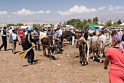
At-Bashy (Kyrgyz: Ат-Башы) is a village in the Naryn Region of Kyrgyzstan, about 35km southwest of Naryn on the main highway to the Torugart Pass. It is the administrative seat of At-Bashy District.2 The At-Bashy Range to the south extends to Lake Chatyr-Kul. The river At-Bashy comes in from the east and then runs northwest through a gorge in the Baybiche-Too range to join the Naryn near Dostuk. It is the last considerable settlement before the Chinese border. The highway, built in 1906, runs southwest between the Baybiche-Too and At-Bashy ranges before turning south and then east to reach the pass. Its population was 14,655 in 2021.1 At-Bashy is also known for the white honey collected from its highlands, based on the esparcet honey plants.3
Population
| Year | Pop. | ±% p.a. |
|---|---|---|
| 2009 | 10,764 | — |
| 2021 | 14,655 | +2.60% |
| Note: resident population; Sources:14 | ||
References
References
- "Population of regions, districts, towns, urban-type settlements, rural communities and villages of Kyrgyz Republic" (XLS) (in Russian). National Statistics Committee of the Kyrgyz Republic. 2021. Archived from the original on 10 November 2021.
- "Classification system of territorial units of the Kyrgyz Republic" (in Kyrgyz). National Statistics Committee of the Kyrgyz Republic. May 2021. pp. 33–34.
- Mountains, Asia. "What to bring from the trip?". Asia Mountains. Retrieved 2024-05-12.
- "2009 population and housing census of the Kyrgyz Republic. Book III. Naryn Region" (PDF) (in Russian). National Statistics Committee of the Kyrgyz Republic. 2010. p. 174.