Artsvanik
Արծվանիկ | |
|---|---|
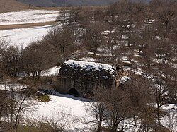 6th-century monastery of Yeritsavank in Artsvanik | |
Artsvanik Artsvanik | |
| Coordinates: 39°15′42″N 46°28′25″E / 39.26167°N 46.47361°E / 39.26167; 46.47361 | |
| Country |  Armenia Armenia |
| Province | Syunik |
| Municipality | Kapan |
| Area | |
• Total | 20.02 km2 (7.73 sq mi) |
| Population | |
• Total | 625 |
| • Density | 31.2/km2 (80.9/sq mi) |
| Time zone | UTC+4 (AMT) |
Artsvanik (Armenian: Արծվանիկ) is a village in the Kapan Municipality of the Syunik Province in Armenia.
Etymology
The village has previously been known as Yeritsvanik, Yeritsvank’, Yertsu Vank’, Karmir Vank’, Yerets’, Yerets and Yeretsvanik.
Demographics
In 1908, Artsvanik (Russian: Арцеваник) had a predominantly Armenian population of 952 within the Zangezur Uyezd of the Elisabethpol Governorate of the Russian Empire.3
The Statistical Committee of Armenia reported its population as 578 in 2010,4 down from 652 at the 2001 census.5
Gallery
-
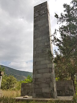 WWII memorial
 -
 Yeritsavank
References
References
- "Syunik regional e-Governance System" (in Armenian). Syunik Province provincial government. Click on link entitled "Համայնքներ" (community) and search for the place by Armenian name.
- Statistical Committee of Armenia. "The results of the 2011 Population Census of the Republic of Armenia" (PDF).
- Кавказский календарь на 1910 год [Caucasian calendar for 1910] (in Russian) (65th ed.). Tiflis: Tipografiya kantselyarii Ye.I.V. na Kavkaze, kazenny dom. 1910. p. 187. Archived from the original on 15 March 2022.
- "Marzes of Armenia and Yerevan City in Figures, 2010" (PDF). Statistical Committee of Armenia.
- Report of the results of the 2001 Armenian Census, Statistical Committee of Armenia