Armamar | |
|---|---|
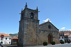 View of Armamar | |
 Flag  Coat of arms | |
 Interactive map of Armamar | |
Location in Portugal | |
| Coordinates: 41°6′34″N 7°41′32″W / 41.10944°N 7.69222°W / 41.10944; -7.69222 | |
| Country |  Portugal Portugal |
| Region | Norte |
| Intermunic. comm. | Douro |
| District | Viseu |
| Parishes | 14 |
| Government | |
| • President | Hernâni Pinto Fonseca Almeida (PPD-PSD) |
| Area | |
• Total | 117.24 km2 (45.27 sq mi) |
| Elevation | 575 m (1,886 ft) |
| Population (2011) | |
• Total | 6,297 |
| • Density | 53.71/km2 (139.1/sq mi) |
| Time zone | UTC+00:00 (WET) |
| • Summer (DST) | UTC+01:00 (WEST) |
| Postal code | 5110 |
| Area code | 254 |
| Patron | São Miguel |
Armamar (Portuguese pronunciation: [ɐɾmɐˈmaɾ] ⓘ) is a municipality in Viseu District in Portugal. The population in 2011 was 6,297,1 in an area of 117.24 km2.2
Geography
Administratively, the municipality is divided into 15 civil parishes (freguesias):3
- Aldeias
- Aricera e Goujoim
- Armamar
- Cimbres
- Folgosa
- Fontelo
- Queimada
- Queimadela
- Santa Cruz
- São Cosmado
- São Martinho das Chãs
- São Romão e Santiago
- Vacalar
- Vila Seca e Santo Adrião
- Coura

References
References
- Instituto Nacional de Estatística Archived November 15, 2016, at the Wayback Machine
- "Áreas das freguesias, concelhos, distritos e país". Archived from the original on 2018-11-05. Retrieved 2018-11-05.
- Diário da República. "Law nr. 11-A/2013, page 552 18" (pdf) (in Portuguese). Retrieved 16 July 2014.
External links
External links