Anorí | |
|---|---|
Municipality and town | |
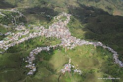 View of Anorí | |
 Flag  Coat of arms | |
 Location of the municipality and town of Anorí in the Antioquia Department of Colombia | |
Anorí Location in Colombia | |
| Coordinates: 7°04′25″N 75°08′45″W / 7.07361°N 75.14583°W / 7.07361; -75.14583 | |
| Country |  Colombia Colombia |
| Department |  Antioquia Department Antioquia Department |
| Subregion | Northeastern |
| Area | |
• Total | 1,430 km2 (550 sq mi) |
| Population (Census 20182) | |
• Total | 14,502 |
| • Density | 10.1/km2 (26.3/sq mi) |
| Time zone | UTC-5 (Colombia Standard Time) |
Anorí is a town and municipality in the Antioquia Department, Colombia. It is part of the subregion of Northeastern Antioquia. The cloud forest near Anorí forms the majority of the range of the endemic, critically endangered chestnut-capped piha.3
The population was 14,502 at the 2018 census.
Climate
| Climate data for Anorí, elevation 1,610 m (5,280 ft), (1981–2010) | |||||||||||||
|---|---|---|---|---|---|---|---|---|---|---|---|---|---|
| Month | Jan | Feb | Mar | Apr | May | Jun | Jul | Aug | Sep | Oct | Nov | Dec | Year |
| Mean daily maximum °C (°F) | 23.1 (73.6) |
23.1 (73.6) |
23.2 (73.8) |
23.5 (74.3) |
24.1 (75.4) |
24.6 (76.3) |
24.8 (76.6) |
24.9 (76.8) |
24.3 (75.7) |
23.5 (74.3) |
23.1 (73.6) |
23.0 (73.4) |
23.8 (74.8) |
| Daily mean °C (°F) | 18.6 (65.5) |
18.7 (65.7) |
18.9 (66.0) |
19.2 (66.6) |
19.6 (67.3) |
19.8 (67.6) |
19.8 (67.6) |
19.8 (67.6) |
19.4 (66.9) |
19.0 (66.2) |
18.8 (65.8) |
18.7 (65.7) |
19.2 (66.6) |
| Mean daily minimum °C (°F) | 14.9 (58.8) |
15.2 (59.4) |
15.6 (60.1) |
16.1 (61.0) |
16.2 (61.2) |
16.1 (61.0) |
15.8 (60.4) |
15.9 (60.6) |
15.7 (60.3) |
15.7 (60.3) |
15.6 (60.1) |
15.4 (59.7) |
15.7 (60.3) |
| Average precipitation mm (inches) | 58.3 (2.30) |
111.5 (4.39) |
156.3 (6.15) |
270.8 (10.66) |
320.7 (12.63) |
296.9 (11.69) |
313.3 (12.33) |
318.4 (12.54) |
327.6 (12.90) |
314.8 (12.39) |
229.9 (9.05) |
119.9 (4.72) |
2,838.5 (111.75) |
| Average precipitation days (≥ 1.0 mm) | 10 | 12 | 16 | 21 | 24 | 22 | 23 | 23 | 23 | 24 | 21 | 14 | 228 |
| Average relative humidity (%) | 90 | 90 | 90 | 90 | 89 | 86 | 84 | 85 | 87 | 89 | 90 | 91 | 88 |
| Mean monthly sunshine hours | 139.5 | 110.1 | 99.2 | 87.0 | 114.7 | 153.0 | 182.9 | 167.4 | 120.0 | 102.3 | 105.0 | 114.7 | 1,495.8 |
| Mean daily sunshine hours | 4.5 | 3.9 | 3.2 | 2.9 | 3.7 | 5.1 | 5.9 | 5.4 | 4.0 | 3.3 | 3.5 | 3.7 | 4.1 |
| Source: Instituto de Hidrologia Meteorologia y Estudios Ambientales4 | |||||||||||||
References
References
- "Municipalities of Colombia". statoids. Retrieved 26 April 2020.
- "Censo Nacional de Población y Vivienda 2018" (in Spanish). DANE. Retrieved 26 April 2020.
- Kirwan, Guy M.; Green, Graeme (2011). Cotingas and Manakins. Princeton: Princeton University Press. p. 399. ISBN 978-0-691-15352-0.
- "Promedios Climatológicos 1981–2010" (in Spanish). Instituto de Hidrologia Meteorologia y Estudios Ambientales. Archived from the original on 15 August 2016. Retrieved 3 June 2024.