Amherst | |
|---|---|
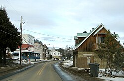 Road 323 in Amherst | |
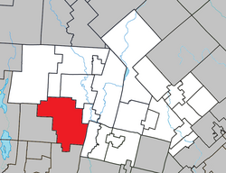 Location within Les Laurentides RCM | |
Amherst Location in central Quebec | |
| Coordinates: 46°03′N 74°46′W / 46.050°N 74.767°W / 46.050; -74.7671 | |
| Country |  Canada Canada |
| Province |  Quebec Quebec |
| Region | Laurentides |
| RCM | Les Laurentides |
| Constituted | March 9, 1887 |
| Named after | Jeffery Amherst1 |
| Government | |
| • Mayor | Jean-Guy Galipeau |
| • Fed. riding | Laurentides—Labelle |
| • Prov. riding | Labelle |
| Area | |
• Total | 249.53 km2 (96.34 sq mi) |
| • Land | 227.86 km2 (87.98 sq mi) |
| Population | |
• Total | 1,559 |
| • Density | 7.6/km2 (20/sq mi) |
| • Change 2016-21 |  5.1% 5.1% |
| • Dwellings | 1,613 |
| Time zone | UTC−5 (EST) |
| • Summer (DST) | UTC−4 (EDT) |
| Postal code(s) | J0T 2L0 & J0T 2T0 |
| Area code(s) | 819 |
| Highways |  R-323 R-323  R-364 R-364 |
| Website | municipalite |
Amherst is a township municipality in the Canadian province of Quebec, located within Les Laurentides Regional County Municipality.
The village of Vendée is also located within the municipality.
Demographics
In the 2021 Census of Population conducted by Statistics Canada, Amherst had a population of 1,559 living in 784 of its 1,613 total private dwellings, a change of 5.1% from its 2016 population of 1,484. With a land area of 227.86 km2 (87.98 sq mi), it had a population density of 6.8/km2 (17.7/sq mi) in 2021.34
Historical census populations – Amherst, Quebec | ||||||||||||||||||||||||||||||||||||||||||||||||||||||||||||||||||||||||||
|
|
| ||||||||||||||||||||||||||||||||||||||||||||||||||||||||||||||||||||||||
| 2021 Population figure based on revised count. Population counts are not adjusted for boundary changes. Source: Statistics Canada456 | ||||||||||||||||||||||||||||||||||||||||||||||||||||||||||||||||||||||||||
Private dwellings occupied by usual residents (2021): 784 (total dwellings: 1,613)4
Mother tongue (2021):3
- English as first language: 4.9%
- French as first language: 92.5%
- English and French as first languages: 1.4%
- Other as first language: 1.4%
Education
Sir Wilfrid Laurier School Board operates English-language schools:
- Arundel Elementary School in Arundel7
- Sainte Agathe Academy (for high school only) in Sainte-Agathe-des-Monts8
References
References
- "Banque de noms de lieux du Québec: Reference number 1186". toponymie.gouv.qc.ca (in French). Commission de toponymie du Québec.
- "Répertoire des municipalités: Geographic code 78070". www.quebec.ca (in French). Gouvernement du Québec.
- "Amherst, Quebec (Code 2478070) Census Profile". 2021 census. Government of Canada - Statistics Canada. Retrieved 2026-05-21.
- "Population and dwelling count amendments, 2021 Census". www12.statcan.gc.ca. Government of Canada - Statistics Canada. Retrieved 2026-05-21.
- Eighth Census of Canada 1941 - Volume II - Population by Local Subdivisions (Report). Dominion Bureau of Statistics. 1944. CS98-1941-2.
- "1971 Census of Canada - Population Census Subdivisions (Historical)". Catalogue 92-702 Vol I, part 1 (Bulletin 1.1-2). Statistics Canada. July 1973.
- "Arundel Elementary Zone Archived 2017-09-16 at the Wayback Machine." Sir Wilfrid Laurier School Board. Retrieved on September 16, 2017.
- "SAINTE AGATHE HIGH SCOOL ZONE Archived 2017-09-04 at the Wayback Machine" [sic]. Sir Wilfrid Laurier School Board. Retrieved on September 17, 2017 - See text description of boundaries in: About Us" as well as the Elementary zone map Archived 2017-09-04 at the Wayback Machine - Note that all areas covered in the elementary map are also covered in the secondary one.