| Amarguillo Arroyo de Valdespino | |
|---|---|
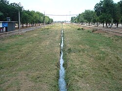 View of the Amarguillo | |
 | |
| Location | |
| Country | Spain |
| Physical characteristics | |
| Source | Collado de la Mirla, Sierra de la Calderina |
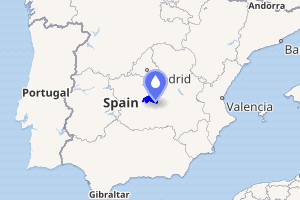
| • location | Urda, Spain |
| • coordinates | 39°19′55″N 3°45′43″W / 39.332°N 3.762°W / 39.332; -3.762 |
| Mouth | Cigüela |
• location | Alcázar de San Juan, Spain |
• coordinates | 39°18′11″N 3°21′14″W / 39.303°N 3.354°W / 39.303; -3.354 |
| Length | 55 km (34 mi) |
Basin size | 563 km2 (217 sq mi) |
| Basin features | |
| Progression | Cigüela→ Guadiana→ Atlantic Ocean |
The Amarguillo is a river in the centre of the Iberian Peninsula and a tributary of the Cigüela. It belongs to the Guadiana river basin.1 In modern times, it is dry during most of the year.2
Description
The watercourse originates to the north of the Collado de la Mirla (in the Sierra de la Calderina, a subrange of the Montes de Toledo) within the Spanish municipality of Urda.34 Featuring a catchment area of around 563 km2, the river runs for 55 kilometers mostly in a west-east direction near the fringes of the Montes de Toledo.2 Historically, the river has been the site of multiple catastrophic floods, including the 1891 one, in which the river reached an estimated flow by Consuegra of 114 m3/s.5 It passes near the Spanish municipalities of Urda, Consuegra, Madridejos, and Camuñas.6 Also known as arroyo de Valdespino in its lower course, it discharges into the Cigüela in the province of Ciudad Real.7
References
References
- Martín Aguado, Máximo (1993). "Semblanza geológica del río Amarguillo" (PDF). Toletum: boletín de la Real Academia de Bellas Artes y Ciencias Históricas de Toledo (29): 63–84. ISSN 0210-6310.
- Potenciano de las Heras et al. 1996, p. 1135.
- Jiménez de Gregorio, Fernando (1999). La Mancha toledana (PDF). Toledo: Diputación Provincial de Toledo. p. 21. ISBN 84-87103-92-8.
- "Villafranca de los Caballeros" (PDF). Provincia (27). Toledo: Diputación Provincial de Toledo: 5. 1960.
- Potenciano de las Heras, A; Martínez Goytre, J.; Durán Valsero, J.J.; Garzón Heydt, G. (1996). "Inundaciones en la cuenca del río Amarguillo (Toledo)" [Floods in the Amarguillo river basin (Toledo)] (PDF). Geogaceta: 1135, 1137.
- Jiménez de Gregorio, Fernando (1987). "Panorámica geográfico-histórica de la villa manchega de Camuñas" (PDF). Beresit: Revista Interdiciplinar científico-humana (1): 146. ISSN 0213-9944.
- Jiménez de Gregorio 1999, p. 21.