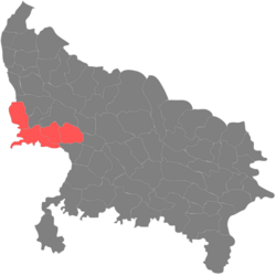
Agra division (Hindi pronunciation: [aːgɾaː]) is one of the 18 administrative geographical units of the northern Indian state of Uttar Pradesh. It contains 4 districts i.e. Agra, Firozabad, Mainpuri and Mathura districts.1 The population of Agra Division was 11,304,646 as of 2011 census.2 Agra city is the headquarters of this division.
Districts
History
During the formation of state of Uttar Pradesh after independence, Agra division included districts of Agra, Aligarh, Mathura, Etah and Mainpuri. Firozabad district was created from Agra district on 2 February 1989. Later, Hathras district was carved out from Aligarh district on 3 May 1997. The then Chief Minister of Uttar Pradesh, Mayawati created a separate Aligarh division which contained the districts of Aligarh, Hathras, Etah and a newly created Kasganj district from Etah district on 15 April 2008.
References
References
- "Agra division, Uttar Pradesh, India". Mindat. Retrieved 8 June 2013.
- "Indian Districts by Population, Sex Ratio, Literacy 2011 Census".
27°11′00″N 78°01′00″E / 27.1833°N 78.0167°E / 27.1833; 78.0167