| Absaroka–Beartooth Wilderness | |
|---|---|
 | |
Location within the United States | |
| Location | Montana / Wyoming, USA |
| Nearest city | Red Lodge, MT |
| Coordinates | 45°6′N 109°56′W / 45.100°N 109.933°W / 45.100; -109.933 |
| Area | 937,102 acres (3,792.32 km2) |
| Established | 1978 |
| Governing body | U.S. Forest Service |
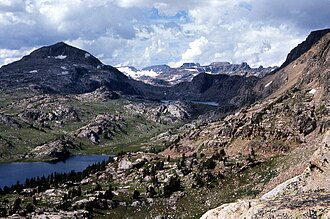
Absaroka–Beartooth Wilderness is a 937,102 acres (3,792.32 km2)1 protected wilderness area on the border of Montana and Wyoming, United States. It was designated by Congress in 19782 and originally comprised 904,500 acres (3,660 km2) in the Custer National Forest and Gallatin National Forest National Forests of Montana.2 The wilderness area was modified in 1983 through the Lee Metcaff Wilderness and Management Act3 and in 1984 through the Wyoming Wilderness Act, which added area from the Shoshone National Forest and brought it to its present total.45
Geology
The namesake mountains have geologically distinct origins. The Beartooth Mountains are composed of granite, while the Absaroka Range is primarily extrusive volcanic and metamorphic rock.6 The Absaroka are noted for their dark and craggy appearance, lush and heavily forested valleys, and abundant wildlife. The highest peak in the Absaroka range within the wilderness area is Tumble Mountain at 11,319 feet (3,450 m). The Beartooth Mountains are more alpine, with huge treeless plateaus and home to Montana's high point: Granite Peak (12,807 feet (3,904 m)). They also have the largest unbroken area of land over 10,000 feet (3,000 m) high in the U.S. outside of Alaska. The wilderness has more than 120 peaks over 10,000 feet (3,000 m) and 28 peaks over 12,000 feet (3,700 m).7
Ecosystem
Threats
The widespread detection of total coliforms, Bacteroides, and E. coli in the water sources of the wilderness area is leading to the question of whether it's because of the increasing human visitation. Visitors to the wilderness are encouraged to purify the water carefully before consumption.8 The wilderness has imposed some regulations to protect the water source, such as camping and burying human waste within 200 feet (61 m) of lake or stream is prohibited, and waste has to be buried 6 inches (15 cm)-8 inches (20 cm) deep.9
References
References
- "Absaroka-Beartooth Wilderness". Wilderness.net. University of Montana. Retrieved July 11, 2026.
- "Public Law 95-249" (PDF). U.S. Congress. March 27, 1978. Retrieved July 11, 2026.
An Act to designate the Absaroka-Beartooth Wilderness, Custer and Gallatin National Forests, in the State of Montana.
- "Public Law 98-140" (PDF). October 31, 1983. Retrieved July 11, 2026.
- "Public Law 98-550" (PDF). October 30, 1984. Retrieved July 11, 2026.
- Aarstad, Rich, et al. "Montana Place Names from Alzada to Zortman: A Montana Historical Society Guide". Montana Historical Society Press. Helena, Montana, 2009, p. 2
- "Shoshone National Forest - Absaroka-Beartooth Wilderness". FS.USDA.gov. Retrieved July 11, 2026.
- Graetz, Rick; Graetz, Susie. "Absaroka-Beartooth Mountains Represent The Roof Of Montana (Part 1 Of 2)".
- Pendergraph, Daniel; Ranieri, John; Ermatinger, Lochlin; Baumann, Adam; Metcalf, Alexander; DeLuca, Thomas; Church, Matthew (2021). "Differentiating Sources of Fecal Contamination to Wilderness Waters Using Droplet Digital PCR and Fecal Indicator Bacteria Methods". Wilderness & Environmental Medicine. 32 (3): 332–339. doi:10.1016/j.wem.2021.04.007. PMID 34172374.
- United States. Forest Service. (2001). Absaroka-Beartooth Wilderness: Custer, Gallatin and Shoshone National Forest: keep wilderness wild, national wilderness preservation system. [Washington, D.C.? : U.S. Dept. of Agriculture, Forest Service 2001].
Further reading
Further reading
- Absaroka Beartooth Task Force. The Proposed Absaroka Beartooth Wilderness: A Wilderness Analysis and Management Recommendation. Bozeman, Mont: [ABTF], 1971.
- Beartooth Publishing. Absaroka Beartooth Wilderness, Montana, Wyoming, Outdoor Recreation Map: Hike, Mountain Bike, Horseback, Dirt Bike, ATV, Fish, Hunt. 2015.
- Coleman, Mervin D. Beartooth Country: The Absaroka and Beartooth Ranges. Helena, MT: Farcountry Press, 2012.
- Schneider, Bill, and Richard K. Stiff. Hiking the Absaroka–Beartooth Wilderness. Guilford, Conn: Falcon, 2015.
- Silkwood, J.T. and G.N. Green. (2000). Generalized geologic map of the Absaroka–Beartooth study area, south-central Montana [U.S. Geological Survey Miscellaneous Field Studies; Map MF-2338]. Reston, VA: U.S. Department of the Interior, U.S. Geological Survey.
- United States. A Proposal, Beartooth Wilderness, Custer and Gallatin National Forests, Montana. [Missoula, Mont]: Dept. of Agriculture, Forest Service, 1974.
- United States. Absaroka Beartooth Wilderness, Custer, Gallatin, and Shoshone National Forests, Montana and Wyoming: 1988. [Missoula]: The Office, 1988.
- Walcott, Francis J., and Rick Amorose. Absaroka–Beartooth Wilderness Study. [San Francisco?]: Sierra Club, 1973. Notes: "A report on the wilderness studies of the Absaroka and Beartooth Primitive Areas and adjacent lands, conducted during the past several years by the Sierra Club. From the Wilderness Committee, Sierra Club."
- Wild resurrection: the untold story of the Absaroka–Beartooth Wilderness. 2018. DVD. Abstract: The history of the Absaroka–Beartooth Wilderness in Montana.
External links
External links
- "Absaroka–Beartooth Wilderness". The National Wilderness Preservation System. Wilderness.net. Archived from the original on October 11, 2007. Retrieved September 16, 2007.
- "USGS Cooke City (MT, WY) Topo Map Quad". TopoQuest. Retrieved June 29, 2008.
- "Wilderness Legislation: The Wilderness Act of 1964". The National Wilderness Preservation System. Wilderness.net. Archived from the original on September 11, 2006. Retrieved August 16, 2006.